🚦【Road Signs】 are an essential component of the urban transport system, spanning across Hong Kong Island, Kowloon, the New Territories, and the outlying islands. They do not merely guide vehicles and pedestrians on their directions, but also carry vital information regarding road planning, traffic safety, and urban culture.
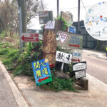
The design of road signs in Hong Kong adheres to international standards while seamlessly blending local characteristics. Apart from the common directional signs and street name plates, there are signs specifically designed for pedestrians, public transport, and special purposes. Geographically, these road signs are tightly intertwined with the road network, becoming an indispensable part of daily city life.
—
📍 Geographical Distribution Features
- Territory-wide Coverage: Road signs are scattered across both urban and rural areas, encompassing expressways, village roads, and pedestrian zones.
- High Urban Density: The density of road signs in urban areas is exceptionally high, commonly seen along major arteries, junctions, and commercial districts.
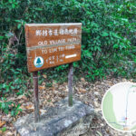
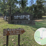
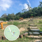
- Countryside Character: Countryside road signs predominantly indicate hiking trails, recreational spots, or nature reserves.
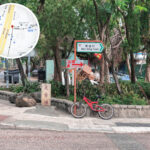
- Bilingual Design: All road signs feature Chinese and English side-by-side, catering to both local residents and international travellers.
- Geographic Positioning: Expressway signs frequently display chainage (kilometre markings) and exit numbers to assist motorists with positioning.
—
🏗️ Basic Design & Categories
Type Features Examples Directional Signs Indicate road alignments and destination distances, typically using a green background with white text Tsing Ma Bridge directional signs, Hong Kong Island tunnel exit signs Street Name Plates Feature a white background with black text, displaying street names with crystal-clear typography Nathan Road, Queen’s Road Central Traffic Regulation Signs Indicate speed limits, no parking, and pedestrian crossings, using red, blue, and white backgrounds “Speed Limit 50 km/h”, “No Parking” Pedestrian Directional Signs Guide pedestrians to footbridges, subways, and exits, typically using a blue background with white text Central Elevated Walkway System signs Countryside Signs Indicate hiking trails and picnic sites, commonly made of wood or metal MacLehose Trail, Lantau Trail signs Temporary Road Signs Utilised for roadworks or traffic diversions, featuring highly vibrant and prominent colours “Road Work Ahead”, “Temporary Diversion” —
⚖️ Legislation & Management
- Design Standards: Strictly comply with the “Road Traffic Ordinance” and international traffic standards.
- Managing Authorities: The Transport Department and Highways Department are responsible for the installation and maintenance of signs.
- Safety Considerations: Placements must avoid obstructing sightlines, while ensuring excellent retroreflective effects at night.
- Replacement Scheme: Regular inspections and replacements are conducted to guarantee clear typography and effective retroreflective coatings.
—
🌆 Community & Cultural Impacts
- Urban Image: Street name plates reflect the history and culture of Hong Kong, such as “Queen’s Road” and “Des Voeux Road”.
- Tourism Guidance: Road signs frequently point towards tourist attractions and transport hubs, offering great convenience to visitors.
- Wilderness Exploration: Hiking trail signs serve as crucial navigation tools for hikers.
- Cultural Heritage: The names on certain road signs originate from the colonial era or local indigenous villages, preserving historical footprints.
—
🗺️ Special Geographical Case Studies
- Tsing Ma Bridge Signage: Expressway signs are clearly designed, explicitly displaying exit numbers and destinations.
- Central Footbridge System Signage: Pedestrian directional signs are densely distributed, seamlessly connecting commercial buildings with MTR stations.
- MacLehose Trail Signage: Countryside hiking trail signs that mark distance posts (kilometres) and directions to aid hikers.
—