💧【Shek Pik • Reservoir (石壁水塘)】 is one of Hong Kong’s major fresh water storage reservoirs, located in a scenic valley in southwestern Lantau Island. Nestled within the South Lantau Country Park and surrounded by lush mountain peaks, it stands as an engineering marvel of the 1960s. Its massive main dam stretches 715 meters long and rises over 50 meters high, creating a storage capacity of over 24 million cubic meters. The massive undertaking required the relocation of several local villages, flooding the valley floor to secure Hong Kong’s post-war water supply. Today, remnants of old ancient trails lie preserved beneath the water, while the historical Shek Pik Rock Carving, located just below the dam, is listed as a declared monument of Hong Kong, beautifully bridging ancient prehistoric art with modern engineering.
📌 Basic Information
Item Details 🏞️ Reservoir Name Shek Pik Reservoir 📍 Location Southwestern Lantau Island, within South Lantau Country Park, adjacent to Shek Pik Village and Shek Pik Prison 🌐 Coordinates 22°13′39.26″N, 113°53′41.63″E 🏗️ Construction Era Commenced: 1957; Completed: 1963. Built by French enterprise Société Française d’Entreprises de Dragages et de Travaux Publics (now Dragages Hong Kong) 💧 Storage Capacity Approximately 24.46 million cubic meters; it was once the largest reservoir in Hong Kong and currently ranks as the third-largest 🚧 Managing Authority Water Supplies Department (WSD) of Hong Kong 🏔️ Surrounding Terrain East: Kau Nga Ling (Dog’s Teeth Range); West: Keung Shan; North: Muk Yue Shan and Sz-to-tau Shan 🛣️ Transport & Facilities The road running over the main dam connects Tai O, Mui Wo, and Tung Chung; Shek Pik Prison is situated directly below the dam 🏘️ Displaced Villages Originally Shek Pik Heung, which included Shek Pik Tai Tsuen, Fan Pui Tsuen, Kong Pui Tsuen, and Hang Tsai Tsuen; residents were relocated to Shek Pik New Village in Tsuen Wan 🏛️ Historic Role Built to tackle Hong Kong’s severe water shortages in the 1950s, serving as a vital component of the early water supply network 🪨 Notable Features Bronze Age rock carvings on the eastern hillside near the dam; surrounded by highly scenic hiking trails 🌿 Natural Environment Extensive afforestation across the catchment area has created a serene environment, excellent for hiking and nature-watching 🚰 Water Supply System Features a system of twin submarine pipelines running underwater via Chau Kung To to Sandy Bay on Hong Kong Island 🧭 Present Day Use While no longer the primary source of supply, it holds immense historical, engineering, and recreational value, drawing many visitors —
🏛️ Historical Background & Community Relocation
In the 1950s, Hong Kong faced acute water shortages, prompting the government to choose the Shek Pik valley for a new reservoir. The valley was home to four long-established villages:
- Shek Pik Tai Tsuen
- Fan Pui Tsuen
- Kong Pui Tsuen
- Hang Tsai Tsuen
The construction meant flooding these ancestral lands, leading to a major community resettlement where villagers moved to the specially built “Shek Pik New Village” in Tsuen Wan. The engineering work was carried out by the French construction company Dragages, which famously completed a twin submarine pipeline system across the seabed to channel water straight to Sandy Bay near Mount Davis on Hong Kong Island. — Today, the grand 54-meter-high main dam and its lakeside paths create a magnificent infrastructure landscape. The reservoir area serves as a central section for Sections 7 and 8 of the famous Lantau Trail, allowing hikers to take in spectacular mirror-like reflections of Nei Lak Shan and Kau Nga Ling across the water’s surface. —
🏗️ Engineering Marvels & Supply Network
- Multi-functional Main Dam:The crest of the dam accommodates South Lantau Road, serving both as a critical water retention barrier and a primary transport artery connecting Tai O, Mui Wo, and Tung Chung.
- Submarine Pipeline System:Extending from Lantau all the way to Hong Kong Island across the ocean floor, this pipeline was hailed as an incredible engineering feat for its time.
- Natural Catchment Basin:Embraced by steep mountains on three sides, the reservoir perfectly captures and stores abundant mountain stream runoffs.
- Afforestation Programs:Large-scale tree planting initiatives around the catchment area have significantly boosted soil conservation and cultivated a thriving local ecosystem.
—
🗿 Cultural Heritage: Prehistoric Rock Carving
On the hillside just east of the main dam lies the Shek Pik Rock Carving. Dating back to the Bronze Age, its geometric patterns offer clear proof of prehistoric human activity on Lantau Island, making it a fascinating cultural gem tucked right alongside a modern reservoir. — Today, Shek Pik Reservoir has evolved into a premier eco-tourism and cultural landmark, easily accessible by direct buses from Tung Chung or Mui Wo. Visitors can marvel at the historic rock carvings near the base of the dam, spot macaques and butterflies along the catchwater paths, and soak in the peaceful natural environment. This harmonious blend of civil engineering, heritage conservation, and eco-conscious recreation makes it a true living museum of Hong Kong’s water history. —
🚶♀️ Hiking Guide: Shek Pik Country Trail Overview
📌 Route Summary
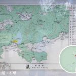
Start Point End Point Distance Time Required Difficulty Shek Pik Reservoir Ngong Ping Approx. 7.9 km Approx. 2.5 hours ⭐⭐ (3 out of 5 stars) 🌟 Highlights Along the Way
- Shek Pik Reservoir Catchwater Meadows: Sweeping green clearings paired with bright blue skies—perfect for landscape photography.
- Fung Pik Stream: Known as one of Hong Kong’s three major demanding stream treks; it is highly recommended to stick strictly to the marked trail unless accompanied by an experienced stream-hiking guide.
- Wisdom Path: A monument featuring the calligraphy of Professor Jao Tsung-I carved into tall wooden columns, arranged in an infinity symbol (∞) to represent endless renewal.
- Ngong Ping Village: Conveniently located near the Tian Tan Buddha and Po Lin Monastery, offering interactive shops, eateries, and cultural exhibits.
—
🚍 Transport & Access
Getting to Shek Pik Reservoir (Alight at Shek Pik Police Post):
- Bus Route 1 / 2: Mui Wo ↔ Tai O / Ngong Ping
- Bus Route 11 / 23: Tung Chung ↔ Tai O / Ngong Ping
Departing from Ngong Ping:
- Bus Route 2: Ngong Ping ↔ Mui Wo
- Bus Route 21 / 23: Ngong Ping ↔ Tai O / Tung Chung
- Ngong Ping 360 Cable Car: Ngong Ping ↔ Tung Chung
—
📸 Tips & Practical Warnings
- 🧴 Always pack plenty of drinking water and sun protection, as there are no shops along the trail.
- 🥾 The surrounding streams involve steep and tricky terrain; stick to the paved Country Trail for a safe walk.
- 📷 Key Photo Spots: The reservoir’s unique bellmouth spillway (the “plug hole”), the grassy slopes below the dam, and the towering timber pillars of the Wisdom Path.
- 🌤️ For summer hikes, start early in the morning to beat the afternoon heat, taking advantage of the shaded forest paths along the way.