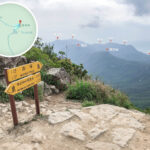
🪵【Tsam Chai Au (斬柴坳)】 is a significant mountain pass situated on the western hillside of Lantau Peak (934m) on Lantau Island. At an elevation of approximately 810 metres, it serves as a key junction for Section 3 of the Lantau Trail. The terrain here is rugged, surrounded by steep slopes and deep valleys, creating a natural mountain pass formation. It connects Lantau Peak, Kau Nga Ling, and Ngong Ping. Renowned for its challenging terrain and magnificent scenery, it is a must-visit landmark for hikers in Hong Kong. Standing here, hikers can overlook the Shek Pik Reservoir and the ridgeline of Kau Nga Ling, or even gaze out at the South China Sea, enjoying spectacular and expansive views.
📌 Quick Facts
Item Details 📍 Location Located on the western hillside of Lantau Peak (934m) ⛰️ Elevation Approx. 810 metres, about 124 metres lower than the summit of Lantau Peak 🪨 Terrain Features
- Rugged mountain pass terrain surrounded by steep slopes and deep valleys
- Natural passage between Lantau Peak and Kau Nga Ling
🌅 Scenery
- To the south, overlook Shek Pik Reservoir
- To the west, see the ridgeline of Kau Nga Ling
- To the north, gaze at the Hong Kong–Zhuhai–Macau Bridge and Tung Chung town centre
—
— Tsam Chai Au is not only a geographical “”crossroads”” but also a stage for hikers to challenge themselves. It connects the Lantau Trail, the Kau Nga Ling Trail, and the South Ridge Trail, each with its own characteristics and difficulties, attracting hikers of all levels to explore. The strange rocks such as the “”Little Bird Turns Back Stone”” and the treacherous sections like the “”Yama Wall”” add layers of culture and legend, making Tsam Chai Au a unique spot that combines natural scenery with human interest. —
🥾 Lantau Trail – Section 3 Hiking Route
- Start: Pak Kung Au (333m)
- Path: Lantau Peak Summit → Tsam Chai Au → Ngong Ping
- Length: Approx. 4.2–4.5 km
- Time: 3.5–4.5 hours (depending on pace and rest)
- Difficulty: High (steep climb to Lantau Peak summit, followed by a long descent to Tsam Chai Au)
- Best Time: Climbing at dawn for the sunrise, or during clear, cool autumn and winter days
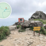
Section Estimated Time Elevation Change Scenic Highlights Pak Kung Au → Initial Stone Steps Approx. 30–40 mins Approx. 340m → 500m Steep stone steps from the start; look back for views of Tung Chung, Hong Kong International Airport, and the HZMB Stone Steps → Pavilion Approx. 30 mins Approx. 500m → 650m Widening views of the Chi Ma Wan Peninsula; spectacular sight of the South Heaven Gate gap on the left Pavilion → Lantau Peak Summit (934m) Approx. 1.5–2 hours 650m → 934m Hong Kong’s second-highest peak; a prime spot for sunrise and sea of clouds; overlook southern Lantau, Shek Pik Reservoir, and Sunset Peak Lantau Peak Summit → Tsam Chai Au (810m) Approx. 40–50 mins 934m → 810m Steep descent, with metal chains for support in some areas; spot the “”Little Bird Turns Back Stone”” along the way Tsam Chai Au → Phoenix Sunrise Archway → Ngong Ping Approx. 40–60 mins 810m → 520m Steep stone steps down to Ngong Ping; visit the Wisdom Path, Po Lin Monastery, and the Big Buddha —
🚍 Transport and Supplies
- Start Point Transport: Tung Chung Station Exit B → Take NLB Bus 3M/11/23 → Alight at Pak Kung Au
- End Point Transport: Ngong Ping → NLB Bus 23 back to Tung Chung, or take the Ngong Ping 360 Cable Car
- Supplies: No supply points along the route; must bring your own water and food. Ngong Ping Village has dining and shops
—
🥾 Route Comparison: Lantau Trail Section 3 vs. Kau Nga Ling
Item Lantau Trail Section 3 Kau Nga Ling Terrain Steep climb to Lantau Peak (934m), followed by a long descent to Tsam Chai Au (810m); large elevation changes Ridgeline as sharp as a knife, narrow path, requires scrambling with hands and feet Difficulty High (suitable for experienced hikers) Extreme (one of the most treacherous routes in Hong Kong) Features Overlook Shek Pik Reservoir and Ngong Ping Pass through treacherous sections like the “”Yama Wall””; extremely challenging Physical Demand Endurance for long-distance hiking; good cardiovascular fitness needed Technical climbing, requires coordination and guts Mental Stress Moderate, primarily from long ascent/descent Extreme, due to narrow ridgelines and proximity to cliffs —
⚠️ Safety Tips
Lantau Trail – Section 3
- ✅ Suitable for: Hikers with some experience
- ✅ Gear: Hiking poles, sufficient water (at least 2 litres), sun protection
- ⚠️ Notes:
- The ascent to Lantau Peak is steep; take it slow and steady
- The descent to Tsam Chai Au is long, placing stress on the knees
- Visibility is poor during bad weather (fog or heavy rain); high risk of getting lost
—
Kau Nga Ling
- ✅ Suitable for: Highly experienced hikers or mountaineering enthusiasts
- ✅ Gear: Gloves, non-slip shoes, helmet (recommended), ropes (some carry them)
- ⚠️ Notes:
- Ridgelines are narrow with cliffs on both sides; maintain focus
- The “”Yama Wall”” requires scrambling; extremely dangerous when wet
- Do not go alone; hike with a partner
- Risk of heatstroke in summer and loss of balance due to strong winds in winter
- No supply points; must carry sufficient water and food
—
🧭 Summary
- Lantau Trail Section 3: An “”endurance challenge”” that tests stamina; perfect for hikers wanting to experience the magnificent views of Hong Kong’s second-highest peak.
- Kau Nga Ling: A “”technical challenge”” focused on treacherous ridgelines and scrambling; extremely high mental pressure, only for experts.
—
📸 Hiking Tips
- Best Season: Autumn and winter for cool weather and clear visibility
- For Challengers: Kau Nga Ling and South Ridge Trail are extremely difficult; require good physical fitness and climbing experience
- Photography Highlights: Sunrise at Lantau Peak summit, panorama of Shek Pik Reservoir, distant view of the Hong Kong–Zhuhai–Macau Bridge
—