🏔️ 【Highland Valleys】 Hong Kong’s topography is defined by its rugged mountains and limited flat land, with valleys typically found in the low-lying areas between ranges. However, in certain high-altitude regions, unique geological and erosional processes have created “highland valleys.” These are relatively flat areas located near mountain slopes or summits, often featuring streams, grassy slopes, and remnants of old terraced fields. Hong Kong’s highland valleys were primarily formed through the long-term weathering and erosion of volcanic, granitic, and sedimentary rocks. Common examples include Ngong Ping near Lantau Peak, Ma On Shan Village on Ma On Shan, and the ruins of the old Pak Lap village near Pak Fu Shan. They are the result of the combined forces of geological evolution and water erosion. —
🪨 Analysis of Formation
1. Geological Background
- Volcanic Regions: Such as Tai Mo Shan and Lantau Peak. Volcanic rock is highly resistant to weathering, creating steep, towering peaks. Erosion often reveals relatively flat valleys along slopes or summits.
- Granite Regions: Such as Ma On Shan. Granite is more susceptible to subtropical weathering, resulting in rounded hills and broader valleys.
- Sedimentary Regions: Such as Pat Sin Leng. Sedimentary rock resistance forms cliffs and narrow gorges, though basin-like valleys can still appear at high altitudes.
—
2. Key Mechanisms
- Weathering: In our subtropical climate, rocks decompose gradually due to long-term exposure to rainfall and temperature fluctuations.
- Erosion: Streams and rainfall cut through ridges to form valleys. Highland valleys, located at higher elevations, collect water at the top or mid-slopes, scouring out flat basins.
- Crustal Movement: Hong Kong is located on the edge of the South China Block. Crustal uplift has elevated some of these valleys to high altitudes, turning them into “highland valleys.”
- Human Activity: Many valleys were historically used for terraced farming or settlement, modifying the landscape to be even flatter.
—
🌿 Characteristics of Highland Valleys
- High Elevation: Mostly between 300 and 900 meters.
- Flat Terrain: Compared to the surrounding ridges, the valleys are basin-like.
- Hydrologically Rich: Frequent streams and waterfalls support diverse ecosystems.
- Cultural Heritage: Locations like the Ngong Ping valley, where flat land facilitated religious sites and settlements.
—
📌 Formation Summary Table
Factor Action Representative Locations Granite Weathering Rounded hills, wide valleys Ma On Shan Sedimentary Resistance Cliffs alongside basins Pat Sin Leng Water Erosion Scouring ridges into flat valleys Ng Tung Chai Crustal Uplift High-altitude basins Ngong Ping — 📖 In short, highland valleys are the product of geological evolution, water erosion, and crustal uplift. They not only showcase Hong Kong’s complex geological history but also nurture unique natural and cultural landscapes. —
📍 Distribution of Major Highland Valleys
1. Lantau Island
- Ngong Ping Valley
- Elevation ~500m; famous for the Ngong Ping Village and the Tian Tan Buddha.
- Characteristics: Highland basin shape; flat terrain ideal for settlements and religious architecture.
—
2. New Territories North
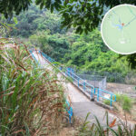
- Ng Tung Chai Valley
- Elevation ~400–500m; west of Pat Sin Leng.
- Characteristics: Spectacular waterfalls and intricate stream networks.
- Ecology: Rich in butterflies and bird species; a popular hiking destination.
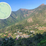
- Ma On Shan Highland Valley
- Elevation ~500m; situated between the ridges of Ma On Shan.
- Characteristics: Flat valley with visible remnants of terraced fields.
- Culture: Once home to villages, preserving traces of past agriculture.
—
3. Sai Kung
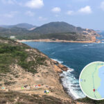
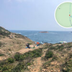
- Pak Tam Valley Highland Zone
- Elevation ~300–400m; within Sai Kung Country Park.
- Characteristics: Interlacing valleys and plateaus; streams and wetlands co-exist.
- Ecology: Diverse plant communities; suitable for ecological education.
—
📌 Highland Valley Overview Table
Valley Name Region Elevation Route Features Difficulty Ngong Ping Valley Lantau Island ~500m Flat basin with Ngong Ping Village & Tian Tan Buddha ⭐⭐ Moderate Ng Tung Chai Valley NT North ~400–500m Spectacular waterfalls, winding streams; can be slippery ⭐⭐⭐ Hard Ma On Shan Valley Sha Tin/Sai Kung ~500m Surrounded by ridges, flat valley with terraced ruins ⭐⭐ Moderate Pak Tam Valley Zone Sai Kung ~300–400m Country park terrain, mixed streams and wetlands ⭐ Easy-Moderate —
🌟 Difficulty Scale
- ⭐ Easy: Short route, flat terrain; suitable for families and beginners.
- ⭐⭐ Moderate: Some uphill or rugged sections; suitable for average hikers.
- ⭐⭐⭐ Hard: Requires good fitness; longer routes or slippery sections.
- ⭐⭐⭐⭐ Challenging: Long-duration climbing, high elevation; for experienced hikers.