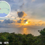
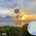
🌊 【Fan Lau • Miu Wan】is a cape situated at the southwestern tip of Lantau Island, Hong Kong, right on the country’s southwesternmost piece of land—the Fan Lau Peninsula. This unique spot marks the exact confluence of the Pearl River Estuary and the South China Sea. Due to the mixing of heavy silt and ocean currents, a sharp boundary divides the muddy yellow river water and the clear blue sea, creating a stunning “two-tone sea” wonder. Fan Lau is not just a treasure trove of natural landscapes; it was also a vital outpost along ancient shipping routes, standing as a testament to Hong Kong’s historical role in maritime defense and shipping.
📌 Basic Info
Name Description Area / Geographical Location 🏝️ Fan Lau Peninsula Located at the southwestern tip of Lantau Island, it is the southwesternmost point of land in Hong Kong. Surrounded by the sea on three sides, it features rugged terrain. Within South Lantau Country Park 🌊 Miu Wan A small, secluded bay tucked next to the peninsula, named for its proximity to the Tin Hau Temple. The coastline is raw and untouched, where local fishing boats often anchor. Bay next to Fan Lau Peninsula 🌅 Fan Lau Phenomenon Situated at the intersection of the Pearl River Estuary and the South China Sea, where the water splits into muddy yellow and clear blue zones, creating a striking “two-tone sea” effect. Estuarine and ocean boundary zone — Beyond its raw natural beauty, Fan Lau and Miu Wan are absolute hotspots for cultural heritage. From the Qing dynasty Fan Lau Fort and the Neolithic Stone Circle to the Tin Hau Temple dedicated to the Goddess of the Sea, and the colonial-era Lantau South Boundary Stone, this patch of land links up ancient civilisations, local fishing traditions, and colonial history. Today, Fan Lau and Miu Wan serve as a hidden paradise for hardcore hikers and the perfect starting point to explore the deep connection between Hong Kong’s culture and nature 🌅. —
🏛️ History & Cultural Heritage
- Fan Lau Fort
- Built during the Yongzheng reign of the Qing dynasty (around 1729), making it one of the oldest forts in Hong Kong.
- Constructed mainly to ward off pirates and foreign invaders, it is now a Declared Monument.
- Fan Lau Stone Circle
- An ancient ruin dating from the Late Neolithic to the Bronze Age.
- Listed as a Declared Monument in 1983, it is believed to have been used for rituals or astronomical observations.
- Fan Lau Tin Hau Temple
- Dedicated to the Goddess of the Sea, Tin Hau, reflecting the deep-rooted faith of local fishermen.
- Miu Wan (literally “Temple Bay”) got its name from this temple.
- Lantau South Boundary Stone
- Erected in 1902 to mark the border of the leased New Territories.
- A crucial landmark for studying Hong Kong’s colonial history.
—
🌅 Natural Landscapes
Spot Description Vibe & Highlights 🏖️ Fan Lau Tung Wan (East Bay) A wide sandy beach, ideal for camping and stargazing. Starlit nights and wild camping vibes. 🌊 Fan Lau Sai Wan (West Bay) A rugged, dramatic coastline with powerful waves crashing against the rocks. Epic seascapes and crashing waves. 🌅 Miu Wan Small, quiet, and peaceful, offering exceptionally stunning sunset views. Golden hour sunsets and peaceful tranquillity. 🌳 Yi O Valley The nearby valley boasts a rich mangrove ecosystem that perfectly complements the coastal views. Eco-watching and wilderness exploration. —
🚶♂️ Hiking Transport & Routes
Spot Difficulty Est. Time Features Shek Pik ⭐ Easy Starting Point Dam views with convenient public transport access. Kau Ling Chung ⭐⭐ Moderate ~1.5 hours Secluded beach and campsite with wide-open coastal views. Fan Lau Tung Wan (East Bay) ⭐⭐ Moderate ~2 hours A massive sandy beach, perfect for stargazing and camping. Fan Lau Fort ⭐⭐ Moderate ~2.5 hours A Qing dynasty fort listed as a Declared Monument. Fan Lau Stone Circle ⭐⭐ Moderate ~3 hours A prehistoric relic packed with high archaeological value. Fan Lau Sai Wan (West Bay) ⭐⭐⭐ Challenging ~3.5 hours Rugged coastline with spectacular crashing waves. Miu Wan Bay ⭐⭐ Moderate ~4 hours A quiet, tucked-away bay with brilliant sunset views. Yi O (Yi O Valley) ⭐⭐ Moderate ~5 hours Lush mangrove ecosystem and valley landscapes. Tai O ⭐ Easy ~6 hours (Finish) Traditional stilt houses, fishing village culture, and killer seafood. —
🧭 Route Overview
- Total Distance: Around 17.5 km
- Total Time Needed: Around 6 hours
- Overall Difficulty: Moderate, best suited for experienced hikers
- Highlights: A brilliant mix of natural wonders (two-tone sea, beaches, mangroves), historic ruins (fort, stone circle, boundary stone), and cultural heritage (Tin Hau Temple)
—
✨ Quick Tips
- Best Season: Autumn and winter, when it is cool, dry, and the visibility is crystal clear.
- Things to Note:
- It is a long haul, so make sure you pack plenty of water and food.
- There are no replenishment stops along the trail; hiking with a buddy is highly recommended.
- Keep an eye on the tides and weather forecast, and avoid heading out during bad weather.