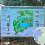
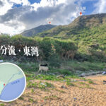
🌊 【Fan Lau (分流)】 is the most remote cape situated at the southwestern tip of Lantau Island, Hong Kong. Boasting a unique geographical location, it marks the dramatic confluence where the Pearl River estuarine waters meet the South China Sea. Once a vital military outpost in ancient times, this area is widely known as the “southwesternmost point of Hong Kong,” featuring spectacular seascapes, ancient ruins, and historic military installations. Home to Stone Age relics, a Qing dynasty fort, abandoned villages, and a stunning coastline, Fan Lau remains an untouched, low-development wilderness. —
📍 Basic Geography & Location
Item Details 🏷️ Name Literally meaning “dividing the flow,” named after the distinct boundary formed where the Pearl River and the South China Sea meet. 📍 Location Southwestern tip of Lantau Island, located within the South Lantau Country Park. 🌊 Highlights Surrounded by the sea on three sides, facing the South China Sea; features a sharp visual contrast between the muddy yellow water of the Pearl River and the clear blue water of the open sea. 🌀 The “Fan Lau” Phenomenon A striking sea boundary created by the mixing of muddy yellow estuarine runoff and clear blue seawater. 🚶♂️ Getting There No direct road access. Accessible only via a 2-hour hike along Lantau Trail (Section 7). ⚔️ Strategic Value A crucial shipping channel for vessels heading to Guangzhou during the Ming and Qing dynasties. Equipped with a fort and lighthouse, holding immense military and maritime significance. —
🏛️ History & Cultural Heritage
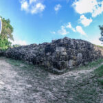
- Fan Lau Stone Circle
- A megalithic monument dating from the Late Neolithic to the Bronze Age.
- Declared a statutory monument of Hong Kong in 1983.
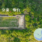
- Fan Lau Fort
- Built in the 7th year of Emperor Yongzheng’s reign (1729) during the Qing dynasty to guard against pirates.
- Measures about 46 metres long and sits on a 70-metre-high hill overlooking the Pearl River shipping lane.
- Declared one of Hong Kong’s earliest statutory monuments in 1981.
- Fan Lau Tin Hau Temple
- Dedicated to Tin Hau, the Goddess of the Sea, reflecting local fishing heritage and beliefs.
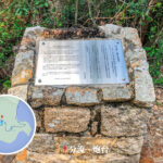
- Lantau South Boundary Stone
- A historic boundary marker charting the colonial border between the Qing government and Great Britain.
- Fan Lau Inscription (Rock Carving)
- A Qing dynasty rock inscription reading “Fan Lau Teng,” carved in 1820 and listed as a statutory monument.
—
✨ Scenery & Hiking Trails
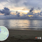
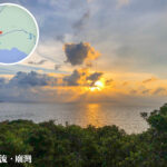
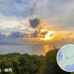
Spot Key Features 🌅 Fan Lau Tung Wan (East Bay) A pristine beach and sweeping coastline, perfect for watching sunsets. 🪨 Fan Lau Sai Wan (West Bay) A rocky shoreline featuring crystal-clear waters. 🏕️ Tsin Yue Wan An unspoilt natural beach, ideal for stargazing and wild camping along the way. 🌳 Yi O A valley with a rich mangrove ecosystem, serving as a connector to Tai O. 🚶♂️ Lantau Trail (Section 7) Hiking Route: Shek Pik → Kau Ling Chung → Fan Lau Tung Wan → Fan Lau Fort → Fan Lau Sai Wan → Tsin Yue Wan → Yi O → Tai O —
🚌 Transport & Accessibility
- No Direct Road Access: There are no roads or ferry services to Fan Lau; you can only get there on foot.
- Main Route:
- Take Bus 11 or 23 from Tung Chung Station, get off at Shek Pik, then hike for about 2 hours via Kau Ling Chung to reach Fan Lau.
- Alternatively, take a bus from Mui Wo to Shek Pik, then start the hike.
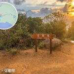
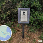
- Lantau Trail (Section 7): Fan Lau is a major highlight along this long-distance trail, packed with heritage sites and raw natural beauty.
🚶♂️ Fan Lau Hiking Route & Heritage Guide
Starting Point: Shek Pik
- Transport: Take Bus 11 or 23 from Tung Chung or Mui Wo and drop off at Shek Pik Reservoir.
- Highlights: The trailhead for Lantau Trail Section 7 is clearly signposted right behind the main dam of Shek Pik Reservoir.
—
Trail Sections
- Shek Pik → Kau Ling Chung
- Time: ~1.5 hours
- Terrain: Shaded dirt tracks with dense greenery typical of South Lantau Country Park.
- Key Features: Kau Ling Chung Campsite (equipped with campfire pits and toilets), a popular pit stop for hikers.
- Photo Op: Frame the transition from the “woodland path” to the “first glimpse of the coastline.”
- Kau Ling Chung → Fan Lau Fort
- Time: ~45 minutes
- Terrain: Coastal path with increasingly wide, open views.
- Key Features: A historic fort built during the Yongzheng era of the Qing dynasty, where ancient stone walls are still clearly visible.
- Fan Lau Fort → Fan Lau Stone Circle
- Time: ~15 minutes
- Key Features: A prehistoric monument from the Late Neolithic/Bronze Age, declared a statutory monument in 1983.
- Photo Op: Use a drone for a top-down view to capture the full shape of the stone circle.
- Fan Lau Stone Circle → Fan Lau Tin Hau Temple
- Time: ~10 minutes
- Key Features: A small, traditional temple dedicated to Tin Hau, offering a peek into local fishing culture.
- Photo Op: Use alternating shots of “incense coils” and “sea views” to highlight the link between faith and nature.
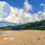
- Fan Lau Tin Hau Temple → Fan Lau Tung Wan (East Bay)
- Time: ~20 minutes
- Key Features: A gorgeous natural beach with sunset views, often with fishing boats anchored offshore.
- Photo Op: A shot of the beach at golden hour makes the perfect closing frame for your trip.
—
🏯 Heritage & Cultural Guide
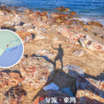
Spot Historical Background Fan Lau Fort Built in 1729 to fend off pirates and safeguard the trade route to Guangzhou; the original stone walls and bastions still remain. Fan Lau Stone Circle Measures about 10 metres in diameter, formed by large boulders. Believed to have been used for ancient rituals or assemblies. Fan Lau Tin Hau Temple Built during the Qing dynasty for fishermen to pray for safe voyages. Active and well-maintained with burning incense to this day. Fan Lau Tung Wan A gently sloping sandy beach with stunning sunset views—ideal for capturing that “sea-meets-sky” aesthetic. Fan Lau Sai Wan Once famous for a giant rock formation resembling a bamboo shoot, which has since disappeared, though striking coastal rock features remain. —
🌿 Natural Highlights
- The Sea Boundary: Where the Pearl River’s muddy yellow water clashes with the South China Sea’s clear blue water, creating a distinct split.
- Coastal Landforms: A diverse landscape featuring headlands, sandy beaches, and unique rock formations.
- Ecosystem: The trail is teeming with wild flowers, butterflies, and birds, with occasional herds of feral cattle grazing on the meadows.
—
⚠️ Difficulty & Safety Tips
- Total Hiking Time: Around 4 hours one way; 7–8 hours for a round trip.
- Difficulty: 🌟🌟🌟 (Moderate; requires a decent level of fitness).
- Important Notes:
- Zero shops or replenishment points along the way; you must pack enough water and snacks.
- Can get scorching hot in summer; starting early in the morning is highly recommended.
- Mobile signals can be patchy; it is best to hike with a buddy.