🥾 【MacLehose Trail – Section 6 (麥理浩徑第6段)】 is the shortest and easiest section of the entire 100-kilometer trail. Spanning roughly 4 to 4.6 km and taking about 1.5 hours to complete, it features beautiful views of the Kowloon Reservoirs, the wild rhesus macaque colonies of Kam Shan, and World War II relics along the Gin Drinkers Line, alongside distant vistas of Lion Rock and the Tsuen Wan cityscape. It beautifully weaves together natural scenery and rich wartime history.
📌 Quick Info
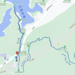
Item Details 🚩 Starting Point Tai Po Road near Golden Hill Road (Kam Shan Road) 🏁 Ending Point Shing Mun Reservoir BBQ Area 📏 Distance Approx. 4.5 km ⏱️ Duration Around 1.5–2 hours 🌟 Difficulty ⭐️☆☆☆☆ (The easiest section, absolutely perfect for beginners and families) ✨ Highlights Kowloon Reservoirs cluster 💧, Kam Shan Macaques 🐒, Smuggler’s Ridge (Ma Tsz Keng) Military Relics 🏰, Distant Views of Lion Rock 🦁 🚌 Transport Start: KMB Bus 72 / 81; End: Green Minibus 82 back to Tsuen Wan 🥤 Supplies Vending machines and local village kiosks available at the ending point —
🗺️ Route & Geographical Highlights
1. 💧 Kowloon Reservoirs Cluster
- Built between the 1910s and 1930s, this is one of Hong Kong’s earliest major reservoir networks.
- Key structures—including the main dam, spillway, and valve house—are recognized as Declared Monuments.
- The glassy water reflections paired with the classic stone masonry create an incredibly nostalgic, historic atmosphere.
—
2. 🐒 Kam Shan (Kam Shan / Monkey Hill)
- Famed for its massive rhesus macaque population, earning it the popular local nickname “Monkey Hill.”
- Macaques were originally introduced to the area to control the spread of the toxic local plant *Strychnos axillaris* (Gelsemium).
- Important Note: Strictly avoid feeding the monkeys or eating in front of them, and always maintain a respectful distance.
—
3. 🏰 Smuggler’s Ridge (Ma Tsz Keng) Wartime Defense Line
- A key stronghold forming part of the World War II Gin Drinkers Line.
- Hikers can spot historical military bunkers, pillboxes, and underground transport tunnels.
- Certain structures are unstable; please view them from a distance and do not enter the ruins.
—
4. 🦁 Lion Rock Overlook
- Reaching the higher elevations offers a magnificent look out toward Lion Rock, the ultimate symbol of the Hong Kong spirit.
- Looking downward reveals the dense concrete sprawl of Kwai Chung Estate, showcasing an incredible overlap of city and nature.
—
5. 🌲 Shing Mun Reservoir
- The endpoint of this section, fully equipped with scenic barbecue sites, picnic areas, and green leisure facilities.
- The tranquil reservoir environment is a haven for local wildlife, where hikers frequently spot egrets and wild squirrels.
- This area also serves as the official starting gate for MacLehose Trail Section 7.
—
🗺️ Section-by-Section Highlights (Timeline View)
Distance Location Landscape / Key Features 0 km Tai Po Road Starting Point Kowloon Reservoirs Cluster 💧—Lush mountain waterscapes framed by historical, grand stone dams. 1 km Golden Hill Road (Kam Shan Road) Monkey Hill 🐒—A heavily active stretch where families of wild macaques are commonly seen. 2 km Smuggler’s Ridge Defense Line Wartime ruins along the Gin Drinkers Line, featuring historic pillboxes and trenches. 3 km High Point Vantage Sweeping panoramic views looking out to Lion Rock 🦁 and the Kwai Chung cityscape. 4 km Shing Mun Reservoir The final relaxation zone, complete with public lawns, pavilions, and picnic spaces. —
🚍 Transport Info
- Getting to the Start:
- KMB Bus 72 (Tai Wo ↔ Cheung Sha Wan)
- KMB Bus 81 (Wo Che ↔ Jordan)
- Leaving from the End:
- Green Minibus 82 (Shiu Wo Street, Tsuen Wan ↔ Shing Mun Reservoir)
—
🥾 MacLehose Trail Comparison: Section 5 vs Section 6 vs Section 7
Section Route (Start ➝ End) Distance / Duration Geographical Terrain Cultural / Historical Highlights Section 5 Tate’s Cairn ➝ Tai Po Road Approx. 10.6 km / 3.5–4 hours Winds along the mountain ridges from Tai Wai to Kam Shan, overlooking Sha Tin and Tolo Harbour. A longer path requiring solid endurance. Features ancient village pathways, old historical footpaths, and extensive ruins along the Gin Drinkers Line. Section 6 Tai Po Road ➝ Shing Mun Reservoir Approx. 4.5 km / 1.5–2 hours Passes the Kowloon Reservoirs, loops through Kam Shan (Monkey Hill) 🐒 and the Smuggler’s Ridge defense line, with distant looks at Lion Rock 🦁. WWII military bunkers, wild macaque habitats, and the scenic, historic leisure dams of Shing Mun Reservoir. Section 7 Shing Mun Reservoir ➝ Lead Mine Pass Approx. 6.3 km / 3 hours A winding, deeply forested trail that offers bird’s-eye views across Shing Mun Reservoir and the Tsuen Wan urban core. Closes in on the foot of Tai Mo Shan. Features the historical mining ruins at Lead Mine Pass and connects directly up to Hong Kong’s highest peak, Tai Mo Shan.