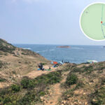
🐯【Pak Fu Shan Path (白虎山徑)】 is located at the southern tip of the High Island (Leung Shuen Wan) Peninsula in Sai Kung, New Territories, Hong Kong. Standing at a modest altitude of approximately 156–173 meters, its completely open and unobstructed terrain allows hikers to overlook the Ngong Kong Islands, the rugged Fa Shan Coast, Pak Lap Bay, and the vast expanses of the High Island Reservoir, offering exceptionally grand and panoramic coastal scenery. Though the trail is not steep or towering, it is widely celebrated for delivering “epic vistas from a small hill,” making it a prized hidden route for nature lovers and landscape photographers. — More than just a scenic vantage point, the Pak Fu Shan Path carries the living history and captivating Feng Shui legends of the surrounding Sai Kung villages. Local folklore tells that the original Pak Lap Old Village suffered from a lack of prosperity and poor health due to the negative geomantic energy of the “White Tiger Malice” (白虎煞). Consequently, the villagers relocated to the new settlement beside Pak Lap Bay and erected the Xuan Tan Temple (玄壇爺廟) to symbolically subdue the tiger and neutralize the malice. This historic move successfully established a highly favorable rural layout traditionally described as “Left Green Dragon (Rocky Hill / Yan Tau Shan), Right White Tiger (Pak Fu Shan).” Walking along this trail, visitors can immerse themselves in magnificent landscapes while connecting deeply with the traditional beliefs and cultural memories woven into Hong Kong’s countryside. —
📌 General Information
Item Details Location Southern tip of the High Island Peninsula, Sai Kung Altitude Approximately 156–173 meters South Side Kei Tau Kok Top (企頭角頂) North Side Pak Lap Bay (白腊灣) Scenic Highlights Unobstructed 360-degree panoramic summit views looking out over the Ngong Kong Islands, Wang Chau, Fo Shek Chau (Basalt Island), and Sha Tong Kok Chau (Bluff Island) Hiking Time 1.5–4 hours (depending on the chosen route length) Difficulty Intermediate; certain sections require basic scrambling Starting Point Pak Lap Village (白腊村) or Pak Lap Wan Beach Cultural Heritage White Tiger Malice folklore, Xuan Tan Temple, and ancestral old village ruins —
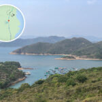
🌄 Coastal Views & Surroundings
- East: The soaring, dramatic cliffs of the Fa Shan Coast (花山海岸).
- South: The vast marine landscapes of the Ngong Kong Islands, Wang Chau, and Fo Shek Chau.
- West: The sheltered waters of High Island (Lan Shuen Wan) and the sweeping expanses of Kau Sai Chau.
- North: The sparkling turquoise waters of Pak Lap Wan Beach (白腊灣沙灘).
—
🚶 Hiking Routes & Trail Difficulty
- Starting Point: Pak Lap Village (白腊村)
- Route A (Intermediate Difficulty): Pak Lap → Pak Lap Old Village Ruins → Pak Fu Shan Summit → Kei Tau Kok Top → Return via the same path to Pak Lap (Approx. 5 hours, 6 km).
- Route B (Advanced Difficulty): Pak Lap → Pak Fu Shan → Kei Tau Kok Top → Ma Tau Wan → Sha Kiu Tsuen → Tung A → Pak Lap (Approx. 6 hours across highly rugged, unmaintained terrain).
- Short Route Version: Setting off directly from Pak Lap Wan Beach, ascending to the summit, and returning via the same path (Approx. 1–1.5 hours, 3 km).
⚠️ Safety Note: The sections approaching the summit ridge line are quite steep and gravelly, requiring careful footing and occasional hand scrambling. —
🏯 Local History & Cultural Lore
- Pak Lap Old Village: Established as an ancestral settlement around 300 years ago. Due to an unfavorable geomantic position, the community suffered from chronic illness and early passings, prompting the eventually complete relocation down to the shores of Pak Lap Wan.
- Feng Shui Legends: Pak Fu Shan was historically feared as the source of the “White Tiger Malice.” To counteract this negative energy, the displaced villagers later constructed the Xuan Tan Temple, placing guardian figures and ancient cannons aimed squarely at the mountain ridge to symbolically conquer the tiger.
- New Village Alignment: The current settlement enjoys a balanced layout, positioning the village in a classical protective pocket between the Left Green Dragon (Rocky Hill) and the Right White Tiger (Pak Fu Shan).
- Old Village Ruins: Hikers can still explore remnants of hand-laid stone walls and old agricultural stone embankments that trace the long heritage of the area’s early settlers.
—
🚖 Transportation Options
- By Taxi: Take an urban or New Territories taxi from Sai Kung Town Center directly to the Pak Lap Village entrance. The journey takes about 20–30 minutes, with fares costing around HK$150.
- By Bus: Take KMB Route 94, 96R, or 289R to the Pak Tam Chung station, and then walk along the MacLehose Trail Section 1 to reach Pak Lap Village, taking about 2 hours total (highly popular on weekends and public holidays).
- On Foot (Trail Access): Follow the designated path from Pak Lap Village to the Pak Fu Shan trailhead, ascending straight to the summit in about 2 hours.
—
📌 Pak Fu Shan Path Summary
- Key Features: Combines a short, low-altitude climb with magnificent sweeping ocean vistas and fascinating cultural Feng Shui lore.
- Best Suited For: Hikers who love exploring off-the-beaten-path paths and capturing panoramic photos of the rugged Sai Kung coastline.
- Essential Advice: Wearing long pants is highly recommended due to overgrown brush. Ensure you pack plenty of hydration (at least 2 liters) and avoid tackling this unshaded path during the extreme heat of mid-summer.
—
⛰️ Kei Tau Kok Top (企頭角頂)
Situated directly south of Pak Fu Shan, this high point features remarkably open, wide-stretching views out toward the Ngong Kong Islands and the vast South China Sea. It is most commonly tackled as an extended ridge walk combined with the Pak Fu Shan Path, making it a highly rewarding challenge for hikers with excellent physical endurance. —
⚠️ Important Safety Notices
- The path is lightly trafficked and the trail markers can be incredibly faint or overgrown; possessing robust directional awareness and a reliable offline GPS trail map is essential.
- Summer temperatures can be punishingly hot, and the entire ridge offers virtually zero shade; always carry an ample supply of fresh drinking water (at least 2 liters recommended).
- It is strongly advised to return via the same path rather than attempting unverified descents down toward Ma Tau Wan, as those unmaintained routes are exceptionally steep, slippery, and hazardous.