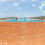
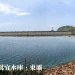
💧【High Island Reservoir (萬宜水庫)】 is located at the Kwun Mun Channel on the Sai Kung Peninsula in the Sai Kung District of Hong Kong. Spanning a surface area of about 6.67 square kilometers, it holds nearly half of Hong Kong’s total reservoir storage capacity. Construction kicked off in 1971 and wrapped up in late November 1978. At the time, it was the newest mega-scale reservoir completed in Hong Kong, and it stands as the world’s very first large-scale reservoir built right in the middle of the sea. Although its catchment area is only about three-quarters the size of Plover Cove Reservoir, its dams were built much higher, giving it roughly 22% more capacity than Plover Cove Reservoir. This makes it Hong Kong’s absolute largest reservoir by storage, boasting a total capacity of 281 million cubic meters.—
—
1. Location & Background
The High Island Reservoir was Hong Kong’s most expensive public works engineering project in the 1970s, built by the British colonial government. The project involved constructing two massive main dams across both ends of the Kwun Mun Channel, connecting the Sai Kung Peninsula with High Island (Leung Shuen Wan), which was Hong Kong’s third-largest island back then. These two main dams tower up to 64 meters high, backed by three auxiliary dams. As Hong Kong’s newest mega-scale reservoir, together with Plover Cove Reservoir (the city’s second largest), it locks down a whopping 87.2% of Hong Kong’s total combined reservoir capacity of 586 million cubic meters. The master plan kicked off in 1969, broke ground in 1971, and fully wrapped up by late November 1978, racking up a total cost of HKD 1.35 billion. To pull off this massive public works project, the colonial government even redrew local administrative borders for the first time, splitting the District Office South into the Sai Kung District Office and Islands District Office. This area has since become Hong Kong’s largest expanse of country parks. The construction flooded several local villages, including Lan Nei Wan Village. Much like the Tai Lam Chung Reservoir, the dramatic landscape changes also carved out islands like Shui King Teng. The reservoir’s original site was the Kwun Mun Channel (also known as the Kwun Mun Channel or Kwun Mun Waterway), making it a remarkable “sea-built reservoir” just like Plover Cove.—
2. Why It Was Built
- Severe Water Crises: From the 1950s to the 1970s, Hong Kong’s population boomed and industrial demands went through the roof, triggering brutal water shortages. Between 1963 and 1964, things got so bad that water was rationed to just once every four days.
- The Game Plan: To smash the water shortage problem once and for all, the colonial government laid out plans in 1969 to build High Island Reservoir, choosing the Kwun Mun Channel between the southern coast of Sai Kung Peninsula and High Island. Ringing in at HKD 1.35 billion, it was one of the most massive public works projects Hong Kong had ever seen.
—
3. Engineering Feats
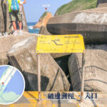
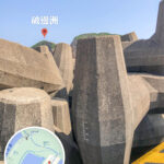
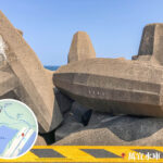
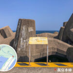
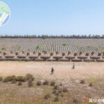
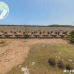
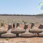
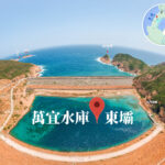
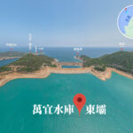
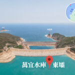
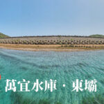
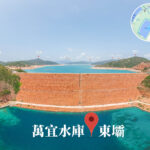
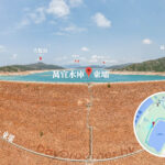
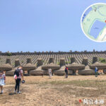
- The Massive Dams: The reservoir is locked down by two main dams (East and West) and three auxiliary dams, completely sealing off the Kwun Mun Channel to form a freshwater lake. Facing the South China Sea, the East Dam stretches 1,593 feet long and stands 348 feet high. It features a spectacular breakwater packed with 2,500 double-T-shaped concrete dolosse blocks to absorb the battering waves. The West Dam faces the inner sea, so its breakwater setup is a bit more straightforward.
- Water Transfer System: The reservoir is hooked up to a network of transfer tunnels stretching around 25 miles long, sending fresh water straight to the Sha Tin Water Treatment Works. It can also swap and balance water levels with Plover Cove Reservoir, giving Hong Kong’s water supply insane flexibility.
—
4. Natural Environment & Landscape
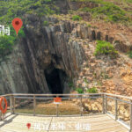
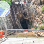
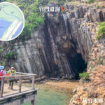
- Geological Wonders: The cliffs right next to the reservoir’s East Dam show off stunning hexagonal rock columns formed by a super-volcanic eruption 140 million years ago. These columns are listed under the Hong Kong UNESCO Global Geopark, carrying immense international geological value.
- Eco Protection: The reservoir’s massive catchment area covers 70 square kilometers across Sai Kung, Ma On Shan, and Sha Tin. To preserve the pristine environment, the colonial government designated the Sai Kung East and West Country Parks, giving the region’s ecological value a major upgrade.
—
5. Tourism & Leisure Activities
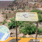
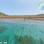
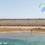
- Hiking Hotspot: High Island Reservoir is the official starting point for Section 1 of the MacLehose Trail. Offering killer views that blend lake scenery, open ocean vistas, and geological relics, it is an absolute paradise for hikers and photography lovers.
- Getting There: Visitors can easily head out from Sai Kung Town Center by catching Bus 94, or hop on Green Minibus 9A (which runs on weekends and public holidays only) straight to the East Dam.
—
6. Social Impact & Historical Legacy
- Village Relocation: The construction of the reservoir completely submerged local villages like Lan Nei Wan Village. The residents were forced to pack up and resettle in Sai Kung Town, altering the local rural landscape forever.
- In Remembrance: Right by the road at the East Dam stands a giant blue anchor monument, built to honor the five project personnel who tragically lost their lives during construction.
— The High Island Reservoir is far more than just a critical water supply facility—it is an epic masterpiece where engineering meets raw natural beauty and geological wonders. With its grand engineering design, rich ecological value, and unique tourism charm, it remains an absolute staple of Hong Kong.