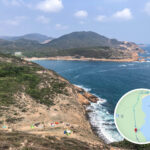
🐯【Pak Fu Shan (白虎山)】 is located at the southern tip of the High Island (Leung Shuen Wan) Peninsula in Sai Kung, New Territories, Hong Kong. Rising to a modest height of approximately 156 meters, its prominent and isolated coastal positioning awards the summit an incredibly vast, unobstructed vantage point over the surrounding waters and scattered outlying islands. To the east lies Fa Shan (花山), to the south stretch the Ngong Kong Islands (甕缸群島) and Fo Shek Chau (火石洲), to the west is Kau Sai Chau (滘西洲), while the pristine white sands of Pak Lap Wan (白腊灣) unfold directly to the north. This spectacular panoramic geographic setting makes Pak Fu Shan a premier hiking destination that masterfully blends rugged natural scenery with a tranquil, off-the-beaten-path atmosphere. —
🗺️ Geographical Features
- Location: At the southern tip of the High Island Peninsula, bordered by Kei Tau Kok Top (企頭角頂) to the south and overlooking Pak Lap Bay (白腊灣) to the north.
- Altitude: 156 meters.
- Scenic Highlights: Offers bird’s-eye views over the Ngong Kong Islands, the rugged Fa Shan Coast, and Wang Chau (橫洲), culminating in a stunning 360-degree panoramic vista from the summit.
—
🏞️ Coastal Views & Surroundings
- East: The dramatic, steep cliffs of the Fa Shan Coast (花山海岸).
- South: The sweeping marine landscapes of the Ngong Kong Islands, Wang Chau, and Fo Shek Chau (Basalt Island).
- West: The calm waters of High Island (Lan Shuen Wan / 糧船灣) and the expanses of Kau Sai Chau.
- North: The turquoise waters and fine sands of Pak Lap Wan Beach (白腊灣沙灘).
—
🚗 Transportation
Mode of Transport Starting Point & Route Duration Notes 🚕 Taxi Sai Kung Town Center → Pak Lap Village Entrance Approx. 25 mins Around $150 HKD per trip Bus Route 94 / 96R / 289R Sai Kung Town Center → Pak Tam Chung → Walk along MacLehose Trail Section 1 → Pak Lap Village Approx. 2 hours Best for weekends and public holidays 🚶 On Foot (Hiking Trail) Pak Lap Village → Pak Fu Shan Trailhead → Pak Fu Shan Summit Approx. 2 hours Total loop route spans roughly 6 km — Beyond its sheer natural beauty, Pak Fu Shan is steeped in local folklore and cultural history. According to heritage tales, the original inhabitants of Pak Lap Village (白腊村) previously settled on the high slopes near the mountain, but faced frequent illness and early passings due to the hill’s geographic profile being viewed as an unfavorable “White Tiger Malice” (白虎煞). To counter this negative energy, the village moved to its current location and built the Xuan Tan Temple (玄壇爺廟), positioning stone guardian beasts and historic cannons aimed squarely at Pak Fu Shan to “tame the tiger.” This rich cultural lineage highlights the traditional Feng Shui beliefs deeply rooted in Hong Kong’s rural past, turning Pak Fu Shan into a fascinating historical landmark where breathtaking mountain-and-sea vistas intertwine with deep local heritage. —
🏘️ Local History & Heritage
- Pak Lap Village: Originally nestled on the higher terrain adjacent to Pak Fu Shan, the settlement was later entirely relocated due to geomantic concerns.
- Old Village Ruins: Hikers can still explore remnants of old stone walls, ruins, and hand-built stone agricultural embankments that serve as silent witnesses to the village’s ancestral past.
- Feng Shui Legends: The “White Tiger Malice” was historically believed to bring misfortune and poor health to the village’s male inhabitants.
—
🏯 Cultural & Feng Shui Lore
- Traditional accounts note that because Pak Fu Shan faced southwest directly toward the old settlement, it disrupted the balance of the community, causing early passings among the village men.
- Seeking guidance from a Feng Shui master, the villagers constructed the Xuan Tan Temple behind the new village site, placing protective stone figures and ancient cannons aimed at the ridge line to symbolically conquer the tiger’s negative aura.
- The eventual relocation created a highly favorable classical layout, successfully aligning the village in a protective “Left Green Dragon, Right White Tiger” layout.
—
—
🧭 Recommended Hiking Route
🔹 Standard Loop Route (Out-and-Back Recommended)
Starting Point Key Waypoints End Point Duration Difficulty Pak Lap Village Pak Lap Village → Pak Lap Old Village Ruins → Pak Fu Shan Summit → Pak Lap Wan Beach → Pak Lap Village Pak Lap Village Approx. 5-7 hours Intermediate For a comprehensive itinerary and trail details, explore 〖Pak Fu Shan • Daydreamer〗. —
📸 Top Photography & Check-In Spots
- Pak Fu Shan Summit: A glorious 360-degree panorama where the vibrant sky seamlessly blends into the blue ocean.
- The Rainbow Village Houses: The colorful, eye-catching candy-hued village homes located in Pak Lap.
- Pak Lap Wan Beach: Known as the Maldives of Hong Kong, featuring a photogenic wooden bridge stretching over the water.
- Kei Tau Kok Top: An adjacent ridge that looks back towards Pak Fu Shan, though the view is slightly framed by local vegetation.
—
🧢 Essential Hiking & Safety Tips
- 🧭 Navigation: Ensure you have an active GPS trail map or offline topo map handy, as several trail branches can be overgrown and faint, requiring basic pathfinding skills.
- 🪨 Footwear: The initial sections of the ascent feature loose scree and rocky gravel slopes; wearing sturdy hiking shoes with solid grip is highly recommended.
- 📵 Connectivity: Cellular reception throughout the peninsula is highly unstable and weak; it is best to hike with a companion rather than venturing solo.
- 🧼 Environment: Please carry out all of your trash and strictly respect the natural wilderness by following Leave No Trace principles.
- 🧺 Supplies: There are no food or water replenishment stations along the mountain trail; make sure to pack ample water and trail snacks.
- 🧴 Protection: Bring adequate sun protection, a hat, and reliable mosquito repellent for the shaded portions of the trail.
—