🛣️【San Tam Road (新潭路)】 is located in the southern part of San Tin, Yuen Long District, New Territories, Hong Kong. It is a two-way, north-south dual-carriageway linking Mai Po Village to Sha Po Village. Running parallel to San Tin Highway and Castle Peak Road (Mai Po and Tam Mei sections), it serves as a major traffic artery for villages in southeastern San Tin. —
1. History and Naming
San Tam Road was constructed in the 1980s as part of the New Territories Circular Road project, initially with the temporary code “Road SR7”. It officially opened to traffic on 30 March 1987 and was formally named “San Tam Road” on 3 December 1993. The name is a portmanteau of “San Tin” and “Ngau Tam Mei”, reflecting its geographical context. —
2. Road Layout and Facilities
- Length and Alignment: Spanning approximately 4 km, San Tam Road starts from the junction of Castle Peak Road – Tam Mei section and Park Vista Access Road in the south, and extends north to Castle Peak Road – Mai Po section near Mai Po San Tsuen.
- Transport Facilities: The road features multiple franchised bus stops and green minibus (GMB) stands, primarily serving nearby villages like Yau Tam Mei and Fung Kat Heung.
- Traffic Restrictions: Certain sections are subject to height restrictions (e.g., underpass tunnels are restricted to vehicles with a height not exceeding 3.5m).
—
3. Public Transport Routes and Services
- Franchised Buses: KMB Route 76K, as well as Cross-Harbour Routes 976 and 976A, are the primary bus services passing through San Tam Road, though they only run on the southbound alignment; northbound trips are diverted via Castle Peak Road – Tam Mei section and San Tin Highway.
- Green Minibuses: Several GMB routes (such as 36, 37, and 38) ply San Tam Road to serve local residents.
- Residents’ Buses: The Kam Sheung Road Cross Boundary All-Day-Pass and Residents’ Bus Route NR93 also make use of sections of San Tam Road.
—
4. Surrounding Villages and Landmarks
- Villages: San Tam Road connects several traditional indigenous villages, including Yau Tam Mei, Fung Kat Heung, and Ngau Tam Mei, all of which retain Hong Kong’s unique rural character.
Landmarks
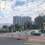
- Fairview Park: Situated at the southern end of San Tam Road, this is a massive low-density residential estate with the Fairview Park Roundabout connecting it to Castle Peak Road.
- Palm Springs: Located near the Ngau Tam Mei bus stop, this is a tropical-themed low-density housing estate.
—
5. Economy and Development
The areas flanking San Tam Road have seen rapid development in recent years. In particular, the completion of low-density residential estates like Fairview Park and California Garden has drawn many middle-class families to the neighborhood. The convenience of the road has also spurred local commercial activity, notably with facilities like the Caltex Fairview Park Petrol Station. — As a key transport corridor in Yuen Long, New Territories, San Tam Road does more than just connect traditional villages—it has witnessed the modern development of the surrounding areas. Its unique geographical setting and historical background make it a perfect microcosm of Hong Kong’s rural-urban integration.