🛣️ 【Victoria Road (域多利道)】 is a winding trunk road on the western shore of Hong Kong Island. Spanning approximately 5.9 km, it connects Kennedy Town and Pok Fu Lam. Built along the coastline against the hills, the road features lush green slopes on one side and vast ocean views on the other, making it both a vital traffic artery and a key thread linking old neighborhoods with emerging communities. Passing through Mount Davis, Sandy Bay, and Telegraph Bay, a short drive here offers a perfect blend of natural beauty and cultural heritage on Hong Kong’s west coast. —
📌 Basic Information
Item Details Chinese Name 域多利道(Victoria Road),原名 Victoria Jubilee Road Location Western part of Hong Kong Island, bordering Central and Western District and Southern District Length Approx. 5.9 km Starting Point Junction of Belcher’s Street and Cadogan Street in Kennedy Town Endpoint Waterfall Bay in Pok Fu Lam, connecting to Pok Fu Lam Road Road Layout Two-lane two-way traffic, speed limit 50 km/h Construction Era Originally built in 1897, expanded in the 1910s, and reconstructed in the 1960s Modern Features Cyberport, Wah Fu Estate, natural landscapes, and historical relics — Historically, the construction of Victoria Road dates back to 1897, when it was named Victoria Jubilee Road to mark the Diamond Jubilee of Queen Victoria. Since then, it has witnessed colonial-era urban expansion, World War II military remnants, and the rise of the modern Cyberport. Victoria Road is more than just a street; it is a time capsule of memories. From boundary stones and foundation stones to Wah Fu Estate, every stretch of the road tells a story of Hong Kong’s history and transformation. —
📜 Historical Background
- Built in 1897 to celebrate Queen Victoria’s Diamond Jubilee, it was originally named Victoria Jubilee Road.
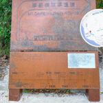
- The foundation stone was laid by Governor William Robinson, who also buried a time capsule beneath it.
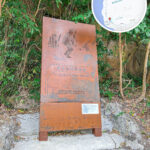
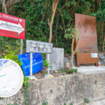
- 1903: A “Boundary Stone of Victoria City” was erected at the start of the road to mark the limits of Victoria City.
- 1910s: The road was widened, and its name was simplified to “Victoria Road”.
- 1960s: Fully reconstructed into a paved concrete road following the completion of Wah Fu Estate.
- 1977: The foundation stone was relocated to the junction with Mount Davis Road, and a new time capsule was added.
- 1992–2002: Expanded and upgraded in three phases to support the development of Sandy Bay and Cyberport.
—
🌿 Geography & Sights Along the Way
- Kennedy Town: The starting point, once an industrial area, now a vibrant hub for residential blocks and hip eateries.
- Mount Davis: A spot filled with military relics and great viewpoints overlooking the western entrance of Victoria Harbour.
- Sandy Bay: Home to HKU-affiliated medical institutions and sports facilities.
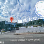
- Telegraph Bay: Now known as Cyberport, a tech and business park.
- Waterfall Bay: The end of the road, named after its natural waterfall and located right next to Wah Fu Estate.
—
🏛️ Culture & Heritage
- Foundation Stone: Commemorates the 60th anniversary of Queen Victoria’s reign.
- Boundary Stone: Marks the historical borders of Victoria City.
- Community Center: The Bayanihan Kennedy Town Centre located at 55 Victoria Road.
- Government Facilities: Government offices and facilities situated at 800 Victoria Road.
—
🚍 Transport & Usage
- Major bus routes: 971, 43M, and green minibus 58, among others.
- Function: Apart from Pok Fu Lam Road, it is the only road linking Kennedy Town and Pok Fu Lam.
- Surroundings: Mainly low-to-medium-density residential areas, with relatively low public transport volume along certain sections.