🏖️ 【Tombolo】 is a unique natural coastal landform found along Hong Kong’s shoreline. Formed over long periods by the persistent action of waves and tides, sediments are gradually deposited into a natural sandbank, creating a spectacular “sea-crossing path” that connects an island to the mainland or two islands together. This “natural bridge” is clearly visible during low tide, resembling a walkway stretching across the sea. During high tide, it is submerged by seawater, forming a “disappearing road” that reveals the mystery and raw power of nature.
🌊 Formation and Characteristics of Tombolos
Item Description 🏖️ Formation Principle Sediments are deposited by wave and tidal action into a sandbank (spit) that bridges an island and the mainland, or two islands. 🌊 Tidal Dynamics The sandbank is exposed during low tide and vanishes during high tide, presenting a “now-you-see-it-now-you-don’t” natural phenomenon. 🪨 Geological Value Often associated with ancient rock layers such as volcanic rocks, breccia, and rhyolite, recording volcanic activity from hundreds of millions of years ago. 🚶♂️ Tourism Appeal Appears as a “sandbank path” during low tide, allowing visitors to walk on it, creating a romantic landscape often compared to an “Angel’s Path.” It becomes a “disappearing road” when submerged at high tide. —Hong Kong’s tombolos are not only geological marvels but also tourism and cultural highlights. Some are located within the Hong Kong UNESCO Global Geopark, boasting ancient rock formations that document volcanic events from over a hundred million years ago. 🌋 Simultaneously, they have become popular destinations for hiking, photography, and sightseeing. Locations like the “Angel’s Path” at Sharp Island in Sai Kung and Ma Shi Chau in Tai Po allow visitors to experience the romance and majesty of nature as the tides shift.—
📍 Major Tombolo Sites in Hong Kong
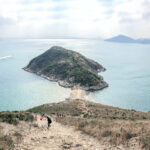
Location Characteristics Geological/Cultural Value Sharp Island (Sai Kung) The most famous “Angel’s Path,” where a sandbank connects to the islet of Kiu Tau during low tide. Volcanic breccia, “pineapple bun” rocks; part of the Global Geopark. A top photography hotspot. Ma Shi Chau (Tai Po) A sandbank connects the islet to the main island, accessible on foot during low tide. Ancient sedimentary rocks and fossils; high educational value for geology. Cheung Sok Island (Sunny Bay) Located near Disneyland, the sandbank appears during low tide. Spectacular scenery, suitable for casual hiking and photography. Ap Lei Pai (next to Ap Lei Chau) A small island connected to Ap Lei Chau by a sandbank. Tide-dependent; suitable for adventure-seeking hikers. Gai Yik Kok The sandbank shifts with the tides, featuring unique terrain. A hidden, lesser-known gem; suitable for explorers. —
🌟 Cultural and Natural Significance
- Natural Beauty: Forms a natural “sandbank walkway,” often likened to the “Angel’s Path” in Shodoshima, Japan.
- Geological Education: Some tombolos are part of the Global Geopark, holding significant scientific and educational value.
- Tourism Value: Combines hiking, sightseeing, and photography, serving as a unique coastal resource for Hong Kong.
- Cultural Symbolism: Tombolos symbolize “connection” and “fleeting paths,” often metaphorically representing the impermanence of life and the power of nature.
—
🪨 Special Geological Highlights
- Pineapple Bun Rock (Sharp Island, Sai Kung): Granite surface weathered by thermal expansion and contraction, creating cracks resembling Hong Kong’s signature “pineapple bun” pastry.
- Volcanic Breccia: Formed by the solidification of rock fragments and volcanic ash following an eruption; records volcanic activity from 143 million years ago.
- Sedimentary Fossils (Ma Shi Chau): Preserves traces of ancient marine life, holding high scientific and educational importance.
—
⚠️ Visitor Tips
- Tidal Observation:
- The sandbank is only revealed during low tide.
- It is recommended to check the tide forecast from the Hong Kong Observatory.
- Best Viewing Time:
- Low tide (especially during the spring tides of the 1st and 15th days of the Lunar month) when the sandbank is most distinct.
- Safety Advice:
- The sandbank is covered with loose gravel; wear anti-slip shoes and avoid slipping or getting trapped. Do not attempt to cross during rising tides.
- Note the return time to avoid being stranded when the tide rises.
—
🌊 Optimal Tidal Viewing Schedule
Location Best Viewing Period Characteristics Precautions Ma Shi Chau Low tide (daily) Global Geopark; rich rock formations. Submerged at high tide; check tide tables. Sharp Island Low tide (spectacular during spring tides) “Angel’s Path” photography hotspot. Sandbank disappears at high tide; check Observatory data. Ap Lei Pai Low tide Narrow sandbank connecting to Ap Lei Chau. Dangerous at high tide; only cross during low tide. Gai Yik Kok Low tide Unique terrain shifting with tides. Harder to access; bring own supplies and safety gear. —
🌊 How to Check Tides
- The Hong Kong Observatory provides daily tide tables for various regions, allowing for precise checking of High and Low tide times.
- Sharp Island is particularly popular; ensure you verify both tide times and ferry schedules before departure to avoid missing the “Angel’s Path.”
—
🗺️ Tombolo Hiking Difficulty Levels
Location Accessibility Route Length Terrain Challenge Overall Rating Ma Shi Chau Medium (Bus to Tai Po + walk) Medium (approx. 2–3 km) Medium (rocky sections, caution needed) ⭐⭐ Sharp Island Medium (Boat from Sai Kung Pier) Short (sandbank walk approx. 500m) Low–Medium (tide dependent, may involve wading) ⭐⭐ Ap Lei Pai High (Accessible via MTR Wong Chuk Hang Station) Medium (approx. 2 km round trip) Medium–High (narrow sandbank, major tidal impact) ⭐⭐⭐ Gai Yik Kok Low (Inconvenient; private car or long walk required) Medium–Long (approx. 3–4 km) High (rugged terrain, high tidal variability) ⭐⭐⭐⭐ —
📌 Rating Explanation
- Accessibility: Based on connectivity via MTR/ferries.
- Route Length: Short (< 3 km).
- Terrain Challenge: Based on sandbank width, tidal impact, and rocky difficulty.
- Overall Rating: ⭐ is easiest; ⭐⭐⭐ and above are suitable for experienced hikers.