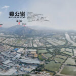
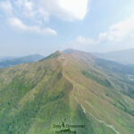
🐔 【Kai Kung Leng】(The stunning mountain range in northwest HK) is a famous peak in the Northwest New Territories of Hong Kong. Standing at 585 meters above sea level, it is located between Kam Tin and Pat Heung in Yuen Long, featuring a volcanic rock ridge terrain. The mountain consists of two main peaks: Law Tin Teng (585m) and Kai Kung Shan (374m). Kai Kung Leng was originally called “Kwai Kok Shan” or “Gwa Kok Shan”, named after its horn-like shape. According to the “Xin’an County Gazetteer”, it got the name “Kwai Kok Shan” because the mountain was packed with old cassia trees and the two peaks faced each other like horns.
📍 Info & Geography
Item Details Peak Kai Kung Leng (Originally: Kwai Kok Shan / Gwa Kok Shan) Main Summit Law Tin Teng Elevation Approx. 585 m Ridge Structure Kai Kung Shan → Kwai Kok Shek Leng → Law Tin Teng → Lung Tam Shan Location Between Kam Tin and Pat Heung, Yuen Long Country Park Lam Tsuen Country Park —
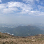
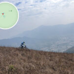
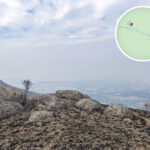
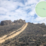
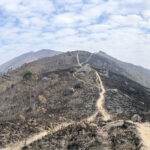
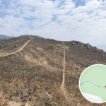
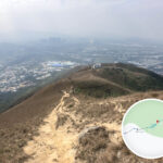
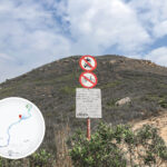
—The ridge of Kai Kung Leng runs from east to west, with Tsiu Keng and Fung Kat Heung at each end serving as the main trailheads. The views here are absolutely legendary—from the summit, you get a panoramic view of the Yuen Long Plain and Mai Po wetlands, stretching all the way to downtown Shenzhen and Shekou. However, the natural landscape has taken quite a hit due to illegal dirt biking and frequent hillfires.—
🗺️ Hiking Routes
🔁 Popular Route: Starting from Fung Kat Heung (Approx. 9km | Takes 6–7 hours)
- Route: Fung Kat Heung → Kai Kung Shan → Earthworm Rock (Yau Yin Shek) → Kwai Kok Shek Leng → Law Tin Teng → Lung Tam Shan → Kiu Tau
- Highlights: Completely open views overlooking Kam Tin, San Tin, Kwu Tung, and Lam Tsuen. Best for experienced hikers.
- Details: 〖Kai Kung Leng • Daydreaming on the Ridge〗
🧭 Short & Sweet Route: Starting from Tsiu Keng (Approx. 6km | Takes 3 hours)
- Route: Tsiu Keng Village → Secondary Peak → Law Tin Teng → Return via the same route
- Highlights: Perfect for beginners or those short on time; great for catching the silvergrass waves and sunset views.
—
🧭 Transport
Starting Point Transport Duration Fare Yuen Long → Fung Kat Heung Green Minibus 603 Approx. 15 mins Approx. $6 Fanling → Tsiu Keng Green Minibus 52B Approx. 15 mins Approx. $7.5 Sheung Shui → Tsiu Keng Green Minibus 57K Approx. 15 mins Approx. $7 —
🌄 IG-Worthy Hotspots
- Main Summit Grassland: An endless sea of rolling green slopes
- Sunset Lookout: Capture the golden hour glow spilling across the Yuen Long Plain
- Cliffside Rock Formations: Epic, rugged boulders perfect for silhouette shots
- Silvergrass Season: From November to January, watch the golden silvergrass sway in the breeze
—
🧰 Gear Checklist
- Hiking shoes with good grip
- Sun hat and sunglasses
- Mosquito repellent
- Power bank and waterproof phone pouch
- At least 2L of drinking water
- Headlamp or flashlight, and never hike alone
—
⚠️ Safety Tips
- The trail is full of loose gravel and sand, so watch your step
- Keep an eye out for dirt bikes zooming past
- Zero shade along the way; high risk of heatstroke in summer
- Wild cattle and monkeys are sometimes spotted; keep your food hidden
- Emergency contact: Dial 999 and share your GPS coordinates
—
📚 Fun Facts & Trivia
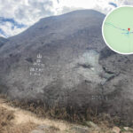
- Originally named “Kwai Kok Shan”—historical records mention a “Fairy’s Dressing Rock” up here
- Song Dynasty scholar Tang Fu once set up the “Lik Ying Academy” right at the foot of the mountain
—