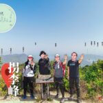
🏔️【Kuai Li Fung (拐李峰)】 is one of the peaks of Pat Sin Leng in Hong Kong, standing at an elevation of approximately 522 metres. It is the fourth highest peak of Pat Sin Leng, and its name comes from Iron Crutch Li (Tie Guai Li), one of the Eight Immortals. Kuai Li Fung is situated on the western side of Pat Sin Leng, and together with the other seven peaks, it forms this famous mountain range. —
—
🧙♂️ Detailed Introduction to Kuai Li Fung
📌 Quick Facts
- Elevation: Approx. 522 metres
- Location: Nestled inside the Plover Cove Country Park in the northeast New Territories, serving as the fifth peak of the Pat Sin Leng Range
- Hiking Route: Part of Wilson Trail Section 9; hikers can start from Tai Mei Tuk and ascend past Sin Kwu Fung all the way to Kuai Li Fung
🧘 Origin of Name
Kuai Li Fung is named after Iron Crutch Li, one of the Eight Immortals in Taoism. He is the most iconic figure among the Eight Immortals, portrayed as a lame old man leaning on an iron crutch, symbolizing perseverance, compassion, and the spiritual pursuit of transcending the physical body. It is said that he could perform astral projection to help those in need, making him a symbol of asceticism and wisdom. —
🌄 Scenery and Natural Features
- Expansive Vistas: Upon reaching the summit of Kuai Li Fung, hikers can enjoy panoramic views overlooking Tolo Harbour, Plover Cove Reservoir, and the Sha Tau Kok area.
- Connected Ridgeline: Kuai Li Fung links up with Tsao Kau Fung and Kao Lao Fung before and after it, forming a spectacular rolling ridgeline.
- Natural Environment:
- Silvergrass blooms beautifully along the path in autumn and winter, making it one of the top routes for silvergrass viewing in Hong Kong.
- The mountain paths consist mostly of stone steps and dirt tracks with distance posts and directional signs along the way, making it well-suited for experienced hikers.
—
🗺 Suggested Hiking Route
🚶♂️ Standard Route (Starting from Tai Mei Tuk)
- Start Point: Tai Mei Tuk. You can take the MTR to Tai Po Market Station, then transfer to Bus Route 75K to Lung Mei Stop.
- Pass by the Spring Breeze Pavilion memorial, then ascend to Sin Kwu Fung.
- Follow the ridgeline to conquer the eight peaks of Pat Sin Leng one by one: Sin Kwu Fung → Sheung Tsz Fung → Choi Wo Fung → Tsao Kau Fung → Kuai Li Fung → Kao Lao Fung → Chung Li Fung → Shun Yeung Fung.
- End Point: Hok Tau Reservoir, where you can leave by catching Green Minibus Route 52B.
⏱ Time and Distance
- Total Distance: Approx. 12 km
- Time Required: Approx. 5–6 hours
- Difficulty: Intermediate to Advanced (⭐⭐⭐); while the undulating ridgeline is manageable, there is absolutely no shade along the path, requiring good physical fitness, proper gear, plenty of water, and sun protection.
—
⛰️ Overview of the Eight Peaks of Pat Sin Leng
English Name Elevation Corresponding Immortal Sin Kwu Fung 511m He Xian-gu Sheung Tsz Fung 513m Han Xiang-zi Choi Wo Fung 489m Lan Cai-he Tsao Kau Fung 489m Cao Guo-jiu Kuai Li Fung 522m Tie Guai Li (Iron Crutch Li) Kao Lao Fung 543m Zhang Guo-lao Chung Li Fung 551m Han Zhong-li Shun Yeung Fung 590m Lu Dong-bin —