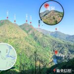
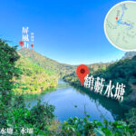
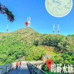
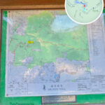
🏞️ 【Hok Tau Reservoir (鶴藪水塘)】 is a charming, crescent-shaped irrigation reservoir nestled in the northern New Territories of Hong Kong. Situated within the scenic expanse of Pat Sin Leng Country Park, it was completed in 1968 with a water storage capacity of approximately 180,000 cubic meters. Its primary engineering function is to collect water streams from the northwestern slopes of the Pat Sin Leng mountain range, funneling it via a dedicated water tunnel into Plover Cove Reservoir, while simultaneously providing irrigation water to neighboring farmland. Tucked away inside a deep valley between Shek Au Shan and Ping Fung Shan, the reservoir serves as the primary source of the Tan Shan River, which eventually flows into the Ng Tung River via the Kwan Tei River. Its concrete dam stands 18 meters tall and spans 102.1 meters in length. Though modest in size, its serene, tree-fringed setting features designated barbecue sites, campsites, and easy hiking trails, making it a beloved destination for families and beginner hikers alike.
📌 Quick Facts
Item Information & Details 🏞 Name Hok Tau Reservoir (鶴藪水塘) 📍 Location Fanling, Northern District, New Territories, within Pat Sin Leng Country Park 🗓 Completion Year 1968 💧 Reservoir Type Irrigation Reservoir (constructed as a satellite component of the Plover Cove Reservoir scheme) 📐 Capacity Approx. 180,000 cubic meters 🧱 Dam Dimensions Height: 18 meters; Length: 102.1 meters 🌙 Shape & Topography Elongated, winding, and uniquely crescent-shaped; nestled in a deep valley between Shek Au Shan and Ping Fung Shan 🌊 Hydrology Upper stream of the Tan Shan River, feeding into the Kwan Tei River and onward to the Ng Tung River 🌳 Ecology Surrounded by dense afforestation areas, secondary forests, fung shui woods, and freshwater wetlands; boasts exceptional biodiversity including rare butterflies, dragonflies, and freshwater fish 🚶♂️ Family Trail Hok Tau Reservoir Family Walk; approx. 2.5 km long, taking about 1 hour to complete 🔥 Facilities Barbecue areas, picnic spots, and a dedicated woodland campsite (Hok Tau Campsite) 🚌 Transport Take Green Minibus 52B from Fanling and alight at the Hok Tau Wai pavilion, then enjoy a short walk to the reservoir — Hok Tau Reservoir is a highly popular weekend retreat for family picnics and overnight camping. It is encircled by the beginner-friendly Hok Tau Reservoir Family Walk as well as the Hok Tau Hiking Trail. The 2.5-kilometer family walk loops effortlessly around the water’s edge in about an hour, offering a flat, beautifully shaded path perfect for children and elderly visitors. The reservoir also intersects with Wilson Trail Section 9, opening up scenic routes toward Pat Sin Leng, the historic abandoned valleys of Sha Lo Tung, or the mirror-like Lau Shui Heung Reservoir. Furthermore, the surrounding woods preserve parts of the ancient “Fung Ma Old Path” (鳳馬古道)—a historic flagstone trail that once served as a primary trade artery connecting Tolo Harbour to Sha Tau Kok. From an ecological perspective, the freshwater marshes and streams here host the endemic Hong Kong Paradise Fish, alongside more than 70 recorded species of butterflies and 50 species of dragonflies, including the rare *Macromidia ellenae* (Idionyx). — To get there, simply board Green Minibus 56K or 52B from the Fanling MTR station and ride it to the Hok Tau Wai terminus, leaving a relaxed 15-minute walk to the reservoir gates. As the area sees heavy foot traffic on weekends and public holidays, an early start is highly recommended. Though small in scale, its quiet glassy waters, lush green peaks, and rich biodiversity make Hok Tau Reservoir a peaceful, slow-living sanctuary away from the urban hustle. —
🚶♀️ Hok Tau Reservoir Family Walk
Item Details 正式長度 Route Length Approx. 2.5 km ⏱️ Duration Approx. 1 hour 🧗♀️ Difficulty Beginner-friendly / Very Easy 🚐 Transport Access Catch Green Minibus 52B from Fanling MTR Station to the “Hok Tau Wai” stop —
📸 Top Photography Spots
- 1️⃣ The Tan Shan River: Captures a serene, picturesque landscape of gently babbling brook waters.
- 2️⃣ Chu Hang Bridge: A lovely, tree-canopied wooden footbridge over intersecting streams—ideal for portrait shots.
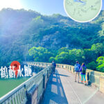
- 3️⃣ The Main Reservoir Dam: Offers a commanding view looking straight down over the water, beautifully framed by distant rolling mountain peaks.
- 4️⃣ The Dam Crest Viewpoint: An elevated vantage point that serves up a perfect, panoramic look at the entire crescent reservoir.
—
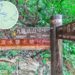
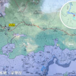
🧭 How to Get to Hok Tau Reservoir
🚐 Public Transport Guide
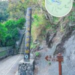
- Head to the Fanling MTR Station and locate the terminus for Green Minibus Route 52B.
- Alight at the Hok Tau Wai stop and follow the paved country road up toward the reservoir.
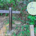
🗺 Recommended Walking Route
- Set off from the Hok Tau Wai pavilion trailhead.
- Pass by the verdant Hok Tau Campsite grounds.
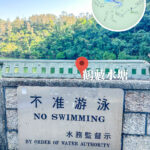
- Stroll along Hok Tau Road until you reach the concrete main dam wall.
- Step onto the loop trail and embark on a relaxing, counter-clockwise walk around the reservoir.
—
🦋 Ecological Highlights
The lush valleys surrounding the reservoir are universally recognized as one of Hong Kong’s premium biodiversity hotspots, making it an absolute paradise for nature observation.
- 🦋 Butterflies: Over 100 species documented, including the majestic Common Birdwing and the iridescent Crows.
- 🐞 Dragonflies: Home to a staggering 72 species, including the rare *Macromidia ellenae*, the Crimson Dropwing, and Yellow Featherlegs.
- 🐟 Wetland Biodiversity: Richly populated by rare native freshwater fish, newts, and diverse amphibian life.
—
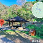
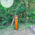
🏕️ Recreational Amenities
- 🍖 Designated Barbecue Zones (BBQ pits and benches available)
- 🏕️ Hok Tau Campsite (equipped with flat tent clearings and sinks)
- 🚻 Managed Public Toilets & Hand-washing stations
—
🌳 On-Site Facilities & Activities
- Spacious woodland BBQ grounds
- Peaceful, designated eco-camping meadows
- Government Experimental Afforestation plots
- Prime butterfly and dragonfly watching decks
—
🚗 Practical Hiking Advice & Tips
- 🧢 ** Beat the Crowds:** Arrive early in the morning on weekends to secure a minibus seat and enjoy a quiet trail.
- 🗺️ **Stay Oriented:** Keep a digital offline map or a country park trail map handy for side trails.
- 🗑️ **Pack it Out:** Carry your own trash bags; help protect this fragile ecosystem by leaving no trace behind.
- 📷 **Pack a Camera:** Bring a macro lens if you enjoy photographing insects and rare flora!
—
🌄 Recommended Trail Extensions
- **The Dual-Reservoir Walk:** Connect directly over the ridge to the nearby Lau Shui Heung Reservoir, creating a highly rewarding 5 km intermediate trek with double the scenery.
- For a grander adventure over the high ridges, look up the comprehensive itinerary: 〖Pat Sin Leng • A Dreamy Ridge Trek〗
—