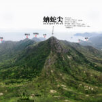
🐍【Sharp Peak (蚺蛇尖 – The Ultimate Challenge of Hong Kong’s Three Sharp Peaks)】 is located in the eastern part of Sai Kung, New Territories. Towering at 468 meters, it is the undisputed leader of Hong Kong’s three sharp peaks, widely celebrated for its razor-sharp profile, punishingly steep scree slopes, and majestic, panoramic ocean vistas. Due to its exceptionally treacherous terrain, the Agriculture, Fisheries and Conservation Department (AFCD) has officially designated it as a “High-Risk Hiking Spot,” and the mountain has tragically witnessed numerous heatstrokes and serious accidents over the years.—
📌 Geography & Naming
Item Details Chinese Name 蚺蛇尖 English Name Sharp Peak Name Origin The proper literary Cantonese pronunciation of “蚺蛇” is “jim4 se4”. However, the English transliteration “Nam She Tsim” adopts the colloquial local reading “naam4 se4” (literally meaning “python”). Summit Elevation 468 meters Location Eastern Sai Kung, situated directly north of Tai Long Wan and south of Nam She Wan on the Sai Kung Peninsula. Coordinates 22°25′51″N 114°22′37″E Geological Features Composed primarily of volcanic rock, the mountain body is heavily weathered and blanketed in loose scree, creating textures that visually mimic “snake scales.” Mountain Profile Sharply pointed and punishingly steep; from a distance, the silhouette resembles a massive serpent rearing its head. Trail Difficulty Officially rated Four Stars (Advanced Level). Risk Assessment Designated as an official High-Risk Hiking Spot. —
—
📖 For an in-depth photo journal and personal trail insights, check out: 〖Sharp Peak • A Dream Journey〗—
🔄 Classic Hiking Loop (Approx. 15 km | 6–8 Hours)
- Pak Tam Au → Chek Keng → Tai Long Au → Sharp Peak → Tai Wan → Ham Tin Wan → Chek Keng → Pak Tam Au
- Cumulative Ascent: Approximately 900 meters
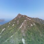
- The Crux Section: The final push to the summit presents extreme slopes angled up to 60 degrees, requiring hands-on scrambling on all fours.
- Suited For: Experienced, well-conditioned hikers equipped with proper gear.
🧭 Sectional Difficulty Breakdown
Trail Segment Distance Duration Difficulty Section Notes Pak Tam Au → Chek Keng 3 km 45 mins ★☆ A gentle, paved descent. Chek Keng → Tai Long Au 1.5 km 30 mins ★★ A steady uphill climb along stone steps. Sharp Peak Ascent (The Summit Push) 1.8 km 2 hours ★★★★ Punishing scree slopes; requires hands-on scrambling. Sharp Peak → Tai Wan 2 km 1 hour ★★★ A narrow, zigzagging ridge path with strong, intense exposure. Tai Wan → Ham Tin Wan → Chek Keng 6 km 2 hours ★★ A mix of sandy beaches and shaded woodland trails. —
🥾 Streamlined Route (Approx. 10 km | 4–5 Hours)
- Ma Liu Shui Pier → Chek Keng → Sharp Peak → Tai Wan → Ham Tin Wan → Chek Keng
- Saves hours of arduous walking on the approach, making it ideal for intermediate scramblers.
- Note: The kaito ferry runs on a highly restricted daily schedule; always verify timetables in advance.
🧭 Sectional Difficulty Breakdown
Trail Segment Incline / Terrain Characteristics Difficulty Rating Chek Keng → Nam She Au Steady uphill climb along stone steps, gradually becoming steeper. ★★☆☆☆ Nam She Au → Summit Aggressive scree slope with near-vertical angles of 60–70 degrees; requires technical hands-on climbing. ★★★★★ Summit → Tai Wan A narrow, zigzagging ridge track featuring high and intense exposure. ★★★★☆ —
🧰 Essential Gear Checklist
Gear Item Recommended Specification Critical Importance Hiking Boots High-traction soles (e.g., Vibram lugs) to bite into loose sand. ★★★★★ Gloves Anti-slip, highly durable, abrasion-resistant. ★★★★☆ Trekking Poles A dual-pole setup is highly recommended for approach management. ★★★★☆ First-Aid Kit Must include heavy-duty elastic bandages and tape. ★★★★☆ Sun Protection Broad-spectrum SPF 50+ sunscreen, sunglasses, and a wide hat. ★★★☆☆ —
🚍 Transport Logistics
- Getting to Pak Tam Au:
- Bus Route 94: Sai Kung Town Centre → Wong Shek Pier (Alight at Pak Tam Au)
- Bus Route 96R (Sundays & Public Holidays only): Diamond Hill MTR Station → Wong Shek Pier
- Alternative Maritime Route: Board a kaito ferry from Ma Liu Shui Pier directly to Chek Keng to bypass the initial overland trekking and save vital energy.
—
📸 Photography & Viewpoint Tips
- The summit’s black-and-white Trigonometrical Station (beacon post) is the quintessential destination photo marker.
- The peak serves up an unparalleled, sweeping bird’s-eye panorama of Sai Kung’s legendary four bays: Tung Wan, Tai Wan, Ham Tin Wan, and Sai Wan.
- Safety First: Never walk or scramble while operating a camera or phone; find secure footing before taking photos.
—
🧗♂️ Technical Challenges & Risks
- Sharp Peak is officially designated as a high-risk hiking spot with a documented history of severe medical emergencies and helicopter rescues.
- The final summit push cuts up a 60-degree incline where the loose, unstable ground rolls easily underfoot, making slips highly common.
- The entire ridge network is completely exposed to the elements with zero shade canopy, and there are no official trail signs or distance posts; navigating requires self-reliance.
- It is strongly advised to utilize offline topographic mapping apps (such as “Hong Kong Hiking Trail”) to prevent path confusion.
- Do not underestimate the water requirements; pack at least 2–3 liters of fluids alongside high-grip footwear and durable gloves.
—
🌅 Optimal Seasons & Timing
Factor Recommendation & Environmental Conditions Hiking Season October to March (Essential to avoid the punishing heat and humidity of summer). Summit Target Time Aim to stand on the peak before 11:00 AM to minimize exposure to heavy afternoon ridge winds. Golden Hours Early dawn and late dusk yield spectacular lighting for capturing the coastal silhouettes. —
🧭 Alternative Trail Variations
Route Variation Core Characteristics Target Audience Novice Observation Run Hike the main valleys and appreciate the fierce profile of Sharp Peak from below without attempting the actual scramble. Beginner hikers and casual walkers. Cheong Tsui Extended Loop Combines the technical peak ascent with an endurance push out to Cheong Tsui, the easternmost peninsula landmark of Sai Kung. Fit hikers with exceptional physical stamina. North Ridge Technical Scramble Tackles the wild, unmaintained North Ridge of Sharp Peak; presents high exposure and strict technical demands. Advanced mountaineers and experienced scramblers. —
⚠️ Heatstroke & Search-and-Rescue Incidents
Sharp Peak’s high-risk designation is underscored by a string of tragic local emergencies:
- July 2022: A 52-year-old male hiker collapsed on the exposed paths from severe heatstroke and tragically passed away.
- February 2021: A 65-year-old hiker lost consciousness on the steep slopes and required emergency air evacuation.
- August 2020: A 16-year-old youth collapsed from acute heat exhaustion during a summer ascent.
—