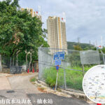
🛣️【Shatin Pass Road (沙田坳道)】 is a historic road located in the eastern part of Kowloon, Hong Kong. Spanning approximately 4.3 kilometers, it connects Choi Hung Road in the Wong Tai Sin District with Jat’s Incline and Fei Ngo Shan Road in the Sha Tin District. Originally constructed by the British Army stationed in Hong Kong during the 19th century, it was once a vital artery between Kowloon and Sha Tin. However, with the opening of the Kowloon-Canton Railway and Tai Po Road in the early 20th century, its strategic transportation role gradually declined. Today, it serves primarily as a residential access road and a popular hiking trail. Shatin Pass Road is permanently split into two disconnected sections at Lung Cheung Road, meaning vehicles cannot pass directly between them. Furthermore, parts of the road are incredibly steep—the incline between Chuk Yuen Road and Tsz Wan Shan Road reaches a maximum slope of 1:5. The stretch from Fat Jong Temple in Tsz Wan Shan up to Shatin Pass is restricted to single-lane, one-way northbound traffic; vehicles heading southbound down the mountain must detour via Jat’s Incline. —
📌 Quick Facts
Category Details 🛣️ Road Name Shatin Pass Road 📍 Location Between Sha Tin District, New Territories and Wong Tai Sin District, Kowloon 📏 Length & Structure Approx. 4.3 km, split into two non-interconnecting segments by Lung Cheung Road 🧭 Start & End Points Choi Hung Road to Jat’s Incline / Fei Ngo Shan Road 🏗️ Historical Background Built in the 19th century by the British Military to link Kowloon and Sha Tin 🧱 Road Features Sections are single-lane one-way with gradients up to 1:5; extreme caution required for drivers 🧘♂️ Hiking Routes Intersection of MacLehose Trail • Section 5 and Wilson Trail • Section 4 🌄 Natural Scenery Offers panoramic views of Lion Rock, the Kowloon Peninsula, Victoria Harbour, and Hong Kong Island 🛕 Cultural Landmark Fat Jong Temple (Established in 1948, dedicated to the Three Jewels Buddha) 🚌 Public Transport Green minibuses (e.g., 37A, 37M, 38M) and several bus routes ⚠️ Notable Incidents Severe landslide during torrential rains in 2008; a KMB bus accidentally drove in and got stuck in 2014 🏞️ Current Status Mainly used for hiking and local residential access, holding immense historical and tourism value — Shatin Pass Road has faced its share of natural challenges. For instance, in June 2008, torrential downpours triggered a massive landslide, forcing the temporary closure of the stretch between the Lion’s Pavilion and Kwun Ping Road. This heavily disrupted hikers on the MacLehose and Wilson Trails until the road was finally reopened in December of that year. In terms of transit, while bus and minibus services are available (such as minibus 18M to Shatin Pass Estate), the narrow, winding nature of the upper sections has occasionally led to larger vehicles mistakenly entering and getting trapped. Today, it remains a heavily favored spot for hiking, morning exercise, and sightseeing, beautifully merging history, transport, and leisure. —
🗺️ Geography & Road Characteristics
- Shatin Pass Road spans across Kowloon and the New Territories, serving as the boundary line between Sha Tin District and Wong Tai Sin District.
- The area near Fat Jong Temple officially falls within Sha Tin District, while the slopes to the south of the road belong to Wong Tai Sin District.
- Lung Cheung Road divides Shatin Pass Road into northern and southern sections, which do not directly interconnect.
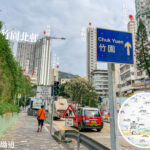
- The northern section leads up to Shatin Pass, the Lion’s Pavilion, and Kwun Ping Road, while the southern section connects to Tsz Wan Shan and Wong Tai Sin Centre.
- Certain parts feature extreme gradients; notably, the segment between Chuk Yuen Road and Tsz Wan Shan Road has a slope of 1:5, making it one of the steepest drivable roads in Kowloon.
—
🚍 Transport & Access Restrictions
- Northbound Uphill Section: The stretch from Fat Jong Temple in Tsz Wan Shan to Shatin Pass is a single-lane, one-way northbound road.
- Southbound Downhill Section: Vehicles must detour via Jat’s Incline to descend the mountain, preventing dangerous head-on traffic.
- Restricted Zone: Vehicles exceeding 5.5 tonnes are prohibited from entering certain sections unless they hold a valid Closed Area Permit.
- Public Transportation:
- KMB routes such as 11C and 113 run along portions of the road.
- Green minibus routes like 37A, 37M, and 38M have designated stops along Shatin Pass Road.
- Residents’ Bus service NR806 connects Kwun Yam Garden with Tsz Wan Shan.
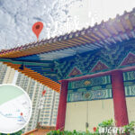
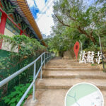
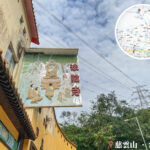
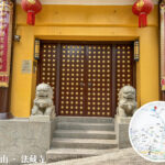
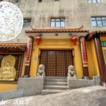
— Shatin Pass Road is far more than just a thoroughfare; it stands as a rich repository of natural, historical, and cultural values. Geographically, the road itself is managed under Sha Tin District, whereas the downhill southern slopes are part of Wong Tai Sin District. Iconic landmarks dot the route, including Fat Jong Temple (located at No. 400 Shatin Pass Road), the Lion’s Pavilion at Shatin Pass (a famous lookout point and resting stop for morning walkers), and the Hang Yick Store (a legendary supply post for hikers). Additionally, the road serves as a primary gateway to Lion Rock Country Park, MacLehose Trail • Section 5, and Wilson Trail • Section 4, enveloping visitors in lush natural scenery with sweeping views over East Kowloon and Sha Tin. —
🥾 Hiking & Natural Vistas
As a major junction for multiple prominent long-distance trails, Shatin Pass Road rewards walkers with spectacular scenery throughout their ascent.
🔗 Hiking Trail Intersections
Trail Name English Name Overlapping Section Location MacLehose Trail • Section 5 MacLehose Trail Section 5 From Lion’s Pavilion to Kwun Ping Road Wilson Trail • Section 4 Wilson Trail Section 4 From Shatin Pass to Tsz Wan Shan 🌄 Key Attractions
Attraction Name Description Lion’s Pavilion Perched at the highest point of Shatin Pass, it overlooks the Kowloon Peninsula and Victoria Harbour, offering an unparalleled vantage point. Fat Jong Temple Built in 1948 and enshrining the Three Jewels Buddha, it is a highly prominent Buddhist temple in Tsz Wan Shan. Kwun Ping Road Leads toward Kwun Yam Garden and Tiu Tso Ngam, providing scenic walks along the ridge. Lion Rock Country Park Shatin Pass Road serves as one of the primary access points into this iconic country park. Marriage Rock & Chiu Po Rock Unique rock formations steeped in local folklore that frequently attract couples and worshippers. —
📜 Historical Timeline
- 19th Century: Constructed by British troops as a military pathway to link the Kowloon garrison with Sha Tin.
- Early 20th Century: Following the launch of the Kowloon-Canton Railway and Tai Po Road, the track gradually transitioned into civilian use.
- 1957: Officially gazetted and named ‘Shatin Pass Road’ (using the variant Chinese character ‘㘭’).
- 1982: To accommodate the expansion of Lung Cheung Road, Shatin Pass Road was permanently severed into two separate, non-connecting northern and southern segments.
- 2008: Severe landslides caused by torrential downpours closed the road from the Lion’s Pavilion to Kwun Ping Road, heavily impacting traffic on MacLehose Trail • Section 5 and Wilson Trail • Section 4.
- 2014: A KMB bus driver mistakenly navigated into the narrow, winding upper mountain pass and got stuck, requiring police assistance to reverse safely back down.
—
🚏 Route and Major Junctions Overview (North to South)
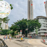
Location / Junction Notes Jat’s Incline / Fei Ngo Shan Road Located near the Jat’s Incline Car Park Viewpoint Kwun Ping Road Connects onward to Kwun Yam Garden and Tiu Tso Ngam Lion’s Pavilion The primary geographic border point between Sha Tin and Wong Tai Sin Districts Tsz Wan Shan Road Starting point of the narrow vehicle restriction zone Chuk Yuen Road One of the steepest road gradients in Kowloon (1:5 slope) Ming Fung Street Key segment traversed by local green minibuses Fung Tak Road Section serviced by franchised public bus lines Lung Cheung Road The major arterial divide; vehicles cannot cross between the north and south sections Choi Hung Road The southern terminus, connecting adjacent to Wong Tai Sin Police Station and MTR Choi Hung Station Area —
⚠️ Tips & Safety Advice
- Drivers must pay close attention to the steep slopes and strict one-way restrictions to prevent accidentally driving into dangerous or unauthorized mountain zones.
- Hikers are highly recommended to wear appropriate gear and check current weather alerts and landslide warnings before setting off.
- Amenities are sparse on the upper mountain stretches, so it is best to carry your own water and light snacks.
—
🧠 Fun Trivia Corner
- While the road is commonly written by the public using the character ‘坳’ (Shatin Pass Road), the official government gazetted name utilizes the variant character ‘㘭’.
- Because the original character ‘㘭’ cannot be displayed correctly on many computer and digital systems, most road signs and maps default to using ‘坳’ for convenience.
- The character ‘坳’ translates directly to a “mountain pass or low valley between hills,” perfectly describing the unique topography of this road.
- Historically, this path served as a vital ancient trade route used to transport locally harvested salt from Kowloon’s salt pans into mainland China.
—