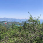
⛰️ 【Tai Tung (大峒)】 is a key peak on the Plover Cove Reservoir Country Trail. Standing at about 310m above sea level, it is nestled within Plover Cove Country Park in the northeastern part of the New Territories. — Tai Tung is one of the highest points along the Plover Cove Reservoir Country Trail. Located right in the middle section of the route, the summit offers sweeping views over the stunning Plover Cove Reservoir, as well as panoramic vistas stretching across to Pat Sin Leng and Tolo Harbour. Since parts of the trail have zero shade and are quite steep, the Agriculture, Fisheries and Conservation Department (AFCD) advises hikers to avoid hitting this trail during the height of summer or in bad weather for safety reasons. It also serves as the very last junction where you can choose to bail out of the full route. —
📍 Geography & Terrain
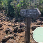
- Location: Situated southeast of Plover Cove Reservoir, right in the mid-section of the Plover Cove Reservoir Country Trail. It sits between Kai Tsz Tung and Kwun Yam Tung near distance post C2608, where you’ll find a directional signpost.
- Elevation: Around 280–300 meters.
- Terrain Features:
- The trail is mostly dirt and rock, with a fair share of loose sand and gravel on the climbs. While it isn’t outright dangerous, you still need to watch your step. Once you top out onto the ridge, the path flattens out and opens up to wide-open views.
- It serves as the junction for the trail heading to Sheung Miu Tin and Ha Miu Tin, making it a handy option if you need to cut your hike short or change routes.
- Importance:
- This is the absolute last bailout point along the mid-section of the trail. If you’re feeling wiped out, it’s best to call it a day and head back down to Wu Kau Tang from here.
- There are zero replenishment spots along the way, so packing enough water and snacks is non-negotiable.
- It’s also a fantastic vantage point for soaking in views of the Double Haven (Yan Chau Tong) islands and Plover Cove Reservoir.
—
📍 Origin of the Name
The name Tai Tung (literally “Big Pack”) likely comes from its shape, which resembles a giant bundle or sack. Some also say it’s because there’s a massive boulder on the hill that looks like a huge head protruding from the ridge.—
🏞️ Scenery & Highlights
- Catch distant views of the Double Haven islands (Yan Chau Tong Marine Park)
- Get a bird’s-eye view across the pristine waters of Plover Cove Reservoir
- Very little canopy cover along the way, so it’s highly recommended to tackle this trail in the morning or during autumn and winter
—
🧭 Trail Overview
Location Highlights Wu Kau Tang Starting point with public transport access; you can get here via green minibus 20R Ma Tau Fung The first peak along the way, standing at 295m Kai Tsz Tung The highest peak of the route at 311m Wang Leng Au A trail junction where you can head towards Kau Tam Tso to loop back to Wu Kau Tang Tai Tung The mid-way junction and the absolute last bailout point; intersects with the route down to Miu Tin Kwun Yam Tung Stands at 304m with wide, open vistas Luk Wu Tung The midpoint of the entire trail; the terrain starts to level out from here with gorgeous scenery Cheung Pai Tun The final major hill before the home stretch; the incline gradually eases off Main Dam A flat 2km stretch of concrete road signaling you’re almost at the finish line Tai Mei Tuk The endpoint, where you can grab a bus or minibus to head home —
🚍 Transport Info
- Starting Point: Wu Kau Tang → Take green minibus 20R
- Ending Point: Tai Mei Tuk → Take green minibus 20C or KMB bus 75K
—
🎒 Gear & Pre-trip Advice
Item Suggestions Timing Aim to start early around 7–8 AM to avoid getting caught out after dark Time Budget Expect to take around 6–8 hours to complete the full trail Water Supply Pack at least 3–4 liters (especially in summer) as there are zero water stops along the way Essential Gear Trekking poles, sun protection, a map or GPS, and a headlamp (just in case you end up night hiking) Difficulty ⭐⭐⭐⭐⭐ (Advanced; widely considered one of the toughest official country trails in HK) Bailout Strategy If you’re running low on gas, remember that Tai Tung is your absolute last chance to exit early Safety First Never hike this trail solo; always go with a buddy and let friends or family know your itinerary Navigation Make sure to download offline maps or track your route via GPS —
🔎 Extra Exploring
If you love this neck of the woods, you can check out our guide to 🥾〖Hung Shek Mun Wanderlust〗. —