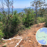
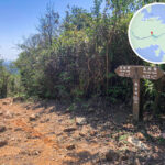
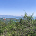
💧【Plover Cove Reservoir • Country Trail (船灣淡水湖 • 郊遊徑)】 is a long-distance hiking route that loops around the Plover Cove Reservoir. Spanning approximately 18–20 km and taking around 7 to 9 hours to complete, it is widely regarded as one of the most challenging trail routes in Hong Kong. The trail kicks off at Wu Kau Tang and conquers multiple peaks along the way, including Ma Tau Fung, Chek Ma Tau, and Tai Tung, reaching a peak elevation of about 310 metres. Hikers can enjoy sweeping, panoramic views of the Plover Cove Reservoir and the stunning scenery of the Tolo Channel. The trail eventually concludes at Tai Mei Tuk. Given that large sections of the trail are highly exposed with zero shade and involve steep scrambles, the Agriculture, Fisheries and Conservation Department (AFCD) strongly advises hikers to avoid tackling it during peak summer or in adverse weather, and to ensure they pack sufficient water and provisions. — The 《 Plover Cove Reservoir Country Trail 》 is not just a grueling test of physical endurance, but also a route rich in historical and ecological significance. The trail wraps around the world’s first freshwater reservoir constructed from a coastal bay—the Plover Cove Reservoir. Its main dam stretches about 2 km, making it the longest water dam in Hong Kong. Along the way, hikers can observe a diverse array of native flora and fauna, alongside the floating solar farm system, which beautifully blends green technology with the scenic landscape. That said, certain notorious sections like “Dit Sai Kau” (Dead Dog Ridge) were once famous for treacherous loose gravel slopes; though steps have been installed in recent years to stabilize the path, it still demands absolute caution. All in all, this trail is tailor-made for experienced hikers looking for a serious challenge, while less-experienced hikers are advised to go with a seasoned group and come fully prepared. —
🧭 Trail Information
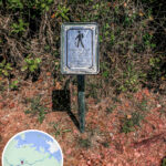
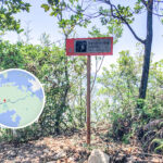
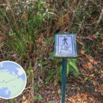
Item Details Starting Point Wu Kau Tang Finishing Point Tai Mei Tuk Total Length Approx. 18–20 km (including the Main Dam) Estimated Time Approx. 7–9 hours Difficulty ⭐⭐⭐⭐⭐ (Very High) Distance Post Codes C2601 to C2620 Replenishment No replenishment points along the way; must bring your own water (at least 4 litres recommended) Best Season Autumn and Winter (to avoid the scorching heat) —
🚍 Transportation
- Getting to the Starting Point: Green Minibus 20R (From Tai Po Market Station → Wu Kau Tang)
- Leaving from the Finishing Point: Green Minibus 20C or KMB Bus 75K (Tai Mei Tuk → Tai Po Market MTR Station)
—
📍 Route Overview & Landmarks
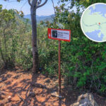
No. Location (Chinese) Location (English) Elevation Features & Remarks 1 烏蛟騰 Wu Kau Tang Approx. 50 m Starting point, accessible via Green Minibus 20R 2 馬頭峰 Ma Tau Fung 295 m The first peak, offering wide-open panoramic views 3 赤馬頭 Red Horse Head Approx. 280 m No prominent landmark; lots of loose gravel, watch your step; connects to Kai Tsz Tung 4 雞仔峒 Kai Tsz Tung 311 m The highest point of the entire trail 5 橫嶺坳 Wang Leng Au Approx. 250 m A trail fork where you can bail out back to Kau Tam Tso 6 大峒 Tai Tung Approx. 270 m Intersects with the Sheung/Ha Miu Tin trail; the absolute last bailout point 7 觀音峒 Kwun Yam Tung 304 m Offers distant views of the Double Haven islands 8 紅石門坳 Hung Shek Mun Au Approx. 200 m Heavy ups and downs with numerous loose gravel slopes 9 鹿湖峒 Luk Wu Tung 280 m A major mid-way landmark with breathtaking vistas 10 鵝髻頂 Ngo Kai Ting Approx. 270 m Located near Distance Post C2615 11 虎頭沙 Fu Tau Sha Approx. 260 m Scree and loose rocks; hike with extra caution 12 三門山 Sam Mun Shan Approx. 250 m Nearing the Secondary Dam 13 長牌墩 Cheung Pai Tun Approx. 240 m The final hill, marking the end of the major climbs 14 副壩 Secondary Dam Approx. 10 m The precursor before hitting the Main Dam 15 主壩 Main Dam 0 m A flat 2 km stretch leading straight to the finishing point at Tai Mei Tuk 16 大美督 Tai Mei Tuk Approx. 5 m Finishing point; leave via Green Minibus 20C or KMB Bus 75K —
🧰 Pre-trip Preparation
Item Recommendations Provisions At least 3–4 litres of water, plus high-energy snacks Gear Proper hiking boots, trekking poles, headlamp, and sun protection Timing Highly recommended to set off between 7:00 AM and 8:00 AM; start no later than 9:00 AM to avoid night hiking Safety Tip Zero bailout options along the middle section of the trail—know your limits before committing Fitness Level Demands high physical fitness; best suited for hikers with intermediate to advanced trail experience Gear Suggestion Trekking poles, sun protection, headlamp, and a basic first-aid kit —
🌅 Scenery Along the Way
- Plover Cove Reservoir: Hong Kong’s pioneer mega-reservoir, offering picture-perfect lake and mountain views.
- Plover Cove Country Park: The entire hiking trail is nested within this sprawling park area.
- Yan Chau Tong Marine Park: A pristine nature conservation zone where you can gaze out over islets and stunning shorelines.
- Tolo Channel: Spectacular marine vistas visible as you approach the Main Dam.
- Lo Fu Wat: Home to Hong Kong’s sole pearl cultivation farm nearby.
- Wong Chuk Kok Tsui: A famous geological wonder featuring Hong Kong’s oldest rock formations (Devil’s Fist).
—
📌 Special Reminders
- There are absolutely no replenishment points, pavilions, or shaded areas along the route.
- Once you pass the early bailout point at Tai Tung, there is no turning back or escaping the trail.
- The path is heavily covered in loose scree and gravel with steep gradients—watch your footing carefully.
- Tackling this trail in summer poses severe heat risks; it is highly recommended to wait for the autumn/winter seasons.
- Always check the latest weather forecast beforehand and avoid heading out on rainy days.
—
🔗 Extended Exploration
📍 Plover Cove Reservoir 📍 Yan Chau Tong Marine Park —