🍉 【To Kwa Peng (土瓜坪)】 is an abandoned fishing village located in northeastern Sai Kung, Hong Kong. Nestled in an inner bay south of Ko Tong Hau, its sheltered waters make it an ideal environment for lush mangroves. Following the departure of its villagers, the area has gradually become a serene, desolate haven, now featuring only abandoned village houses, flourishing mangroves, and an isolated lighthouse. The mangrove ecosystem here is remarkably rich; according to research by the City University of Hong Kong, To Kwa Peng is one of the few areas in Hong Kong that simultaneously boasts eight true mangrove species, including Kandelia obovata and Avicennia marina. Combined with intertidal crabs (such as the chiromantes haematocheir) and mudskippers, it has become a major coastal ecological observation point. The village was gradually abandoned starting from the 2010s, leaving behind a few village houses built in the 1960s and a solitary lighthouse (numbered T15). The narrow pier extending into the sea creates a stunning “Mirror of the Sky” reflection on calm days, making it a hotspot for photography enthusiasts.
📍 Geographical & Historical Background
Item Details Chinese Name 土瓜坪 English Name To Kwa Peng District Sai Kung Historical Background Once a fishing village, now completely abandoned as indigenous villagers have moved out. Geographical Location Located in the inner bay of Ko Tong Hau, south of Wong Shek, and adjacent to Uk Tau Village and Tung Sam Kei Village. — To Kwa Peng is relatively easy to get to. A popular route kicks off from Pak Tam Au, heads through Chek Keng or cuts straight into To Kwa Peng, and wraps up at Wong Shek Pier. The whole trail is about 4 km long and takes around 1.5 to 2 hours, making it perfect for beginners or family outings. Since the path is flat and well-shaded, it is a pretty comfortable walk even in the summer. Along the way, you will pass through dense woodlands, abandoned village houses, and wetlands where you can easily spot feral cattle and chiromantes haematocheir crabs. However, do watch out for muddy, slippery sections and occasional wildlife like snakes or cattle. Plus, the historical traces around To Kwa Peng, such as the old leveled orchards and water storage facilities, offer a glimpse into the past lives and farming activities of the villagers, adding a nice touch of cultural depth to the hike. —
🚶 Hiking Route & Transport Info
🔹 Recommended Route
Item Details Starting Point Pak Tam Au Route Pak Tam Au → Chek Keng → To Kwa Peng → Wong Shek Pier Distance Approx. 4 km Duration Approx. 1 hour Elevation Max. 149 m, Min. 1 m 🔹 Transport Options
- 📍 Starting Point: Take KMB Bus 94, 96R, or 289R and get off at Pak Tam Au Station.
- 🚶♂️ Walking: Pak Tam Au → To Kwa Peng, approx. 30 mins.
🔹 Trail Breakdown
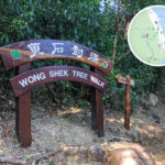
Section Duration Highlights Pak Tam Au → Chek Keng Approx. 40 mins Youth hostel, mudflats, and mangroves. Chek Keng → To Kwa Peng Approx. 40 mins Follow the concrete path past mangroves and a small pier. To Kwa Peng → Wong Shek Pier Approx. 40 mins Connect to Wong Shek Family Walk to finish up the hike. 🔹 Scenic Highlights
- Chek Keng Mudflat: At low tide, a vast expanse of mudflats and mangroves is revealed.
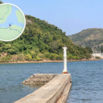
- To Kwa Peng Lighthouse: The white lighthouse sitting at the end of a long, slender pier is a prime spot for photos.
- Tung Sam Kei Hill: Offers distant views of Sharp Peak and the Ko Tong Hau bay.
—
📍 Nearby Attractions Recommended
Attraction Highlights Wong Shek Pier You can take a ferry or kaito to Yim Tin Tsai, Chek Keng, and other spots. Yim Tin Tsai A small island blending Hakka culture with Roman Catholic heritage. Tung Sam Kei Village An indigenous village located near To Kwa Peng. Uk Tau Village The village on the opposite side, which is still inhabited. Ko Tong Hau The bay where To Kwa Peng is nestled. Pak Tam Au The starting point of the hike, very accessible by public transport. —
🌊 Key Attractions & Natural Features
📸 To Kwa Peng Lighthouse
- Perched right at the tip of a small coastal pier.
- Shares a similar architectural design with the Chek Keng lighthouse.
- The slender pier reaches out into the sea, offering magnificent waterfront views.
🌳 Flora & Fauna Along the Way
- Chinese Sweet Gum: The leaves turn a gorgeous red during autumn.
- Mangroves: Great for spotting fiddler crabs and mudskippers.
- Terraced Campsites: Historic remnants of farmland cleared by early villagers.
—
🧭 Surrounding Villages & Place Names
English Name Highlights Uk Tau Village The village on the opposite side, which is still inhabited. Tung Sam Kei Village Can be reached on foot from To Kwa Peng. Wong Shek Pier A major transport hub where you can catch a boat to Chek Keng. Ko Tong Hau The bay where To Kwa Peng is situated. Pak Tam Au The starting point of the hike, very accessible by public transport. —
🧳 Hiking Tips & Advice
- 🧴 Refuel: No shops or kiosks along the trail, so make sure to bring your own water and snacks.
- 🧭 Clear Signposts: Though there are several forks in the road, the signs are clear and the path is easy to follow.
- 📵 Network Coverage: Signal can be weak in certain spots; it’s smart to download offline maps beforehand.
- 📷 Photo Tips: Hit the trail in the morning or around dusk for the most beautiful lighting on the mangroves and lighthouse.
- 🥾 Gear up: Wear shoes with decent grip, and pack plenty of water and insect repellent.
- 🌿 Eco-friendly Reminder: Please don’t pick any plants or leave trash behind—let’s keep these precious wetlands and natural ecosystems pristine.
—
💡 Why Is It Worth a Visit?
- ✅ Get away from the crowds and enjoy some peace and quiet in nature.
- ✅ Perfect for hiking newbies with its straightforward and easy trail.
- ✅ A beautiful mix of historic village vibes and scenic natural landscapes.
- ✅ A must-visit for photography fans to snap the iconic lighthouse and coastal views.
—