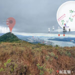
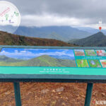
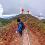
🏔️ 【Peaks / Mountains】Hong Kong is a city dominated by hilly terrain, with over 70% of its land area formed by hills and peaks. There are over 300 peaks scattered across Hong Kong Island, Kowloon, the New Territories, and the Outlying Islands. They not only shape the unique “mountains-sea-city” cityscape, but from the highest Tai Mo Shan to Kowloon’s iconic Lion Rock, these ridges define Hong Kong’s distinctive topography and serve as the backdrop of citizens’ everyday lives. Nestled within these mountains is a diverse natural ecology that showcases varying scenery with the turning of the seasons: the tender greens of spring, the lush canopies of summer, and the silvergrass and seas of clouds in autumn and winter, leaving visitors spellbound.
🌄 Key Features of the Peaks
Feature Description ⛰️ Large Elevation Gradients Spanning from the highest peak, Tai Mo Shan, to lower urban ridges like Kowloon’s Lion Rock. 🌍 Wide Geographical Distribution Iconic peaks are located across Hong Kong Island, the New Territories, Lantau Island, and various Outlying Islands. 🌿 Rich Natural Ecology Nurturing a diverse flora, such as the famous silvergrass landscape on Sunset Peak. 🦁 Cultural Symbols The “Lion Rock Spirit” symbolises the resilience and perseverance of Hong Kong people; Ma On Shan is named after its saddle-like shape. 🚶 Connected by Hiking Trails Long-distance trails like the MacLehose Trail and Lantau Trail link numerous peaks together. —At the same time, Hong Kong’s peaks carry profound cultural and spiritual symbolism. The Lion Rock Spirit represents the unyielding and resilient attitude of Hong Kong people; Lantau Peak and Sunset Peak are holy grails for watching sunrises and sunsets; while Tai Mo Shan is a paradise for astronomy enthusiasts. These peaks are not merely natural landscapes, but also the anchors of history, culture, and the hearts of the people, weaving the city’s stories and natural vistas into a magnificent tapestry.✨
🏔️ Unique Profiles of Hong Kong Peaks
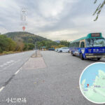
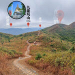
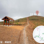
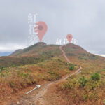
Peak Name Nearest MTR Station Bus / Minibus Routes Remarks Tai Mo Shan Tsuen Wan Station / Yuen Long Station Take Bus 51 from Tsuen Wan to Chuen Lung; or take Bus 64K from Yuen Long to the entrance of Tai Mo Shan Country Park The highest peak in Hong Kong; famous for its seas of clouds, starry night skies, and occasional frost or ice Lantau Peak (Fung Wong Shan) Tung Chung Station Take Bus 23 to Ngong Ping, then ascend on foot The second highest peak in Hong Kong; a premier sunrise destination along the Lantau Trail Sunset Peak (Tai Tung Shan) Tung Chung Station Take Bus 3M to Mui Wo, then transfer to a minibus to Nam Shan or Pak Kung Au Stunning autumn/winter golden silvergrass seas and sunset vistas Ma On Shan Ma On Shan Station Walk directly to the Ma On Shan Country Park entrance, or take a minibus to the trailhead near Heng On Estate Resembles a horse saddle; stands in close proximity to the new town Kowloon Peak (Fei Ngo Shan) Choi Hung Station Take a minibus to Fei Ngo Shan Road; or hail a taxi directly to the summit from MTR Diamond Hill Station Famous for its night views; overlooks the dazzling Victoria Harbour lights and is one of the best vantage points for Kowloon’s cityscape Lion Rock Wong Tai Sin Station / Shek Kip Mei Station Walk from Wong Tai Sin Station to the Lion Rock Country Park entrance; or take a minibus from Shek Kip Mei Station to Lok Fu The ultimate spiritual symbol of Hong Kong; boasts magnificent Kowloon night views; suitable for year-round hiking Sharp Peak (Nam She Tsim) MTR Diamond Hill Station → Bus Take Bus 94 to Sai Kung, then transfer to a minibus to Pak Tam Chung and hike along the MacLehose Trail A sharply pointed summit; highly challenging trail with breathtakingly grand panoramic views Grassy Hill (Tsa Shan) Tai Po Market Station Take Bus 64K to Shing Mun Reservoir, then ascend along the MacLehose Trail Rolling grassy slopes; ideal for a leisurely, relaxing hike Victoria Peak (The Peak) Admiralty Station / Central Station Take the Peak Tram; or take Citybus Route 15 departing from Central Star Ferry Pier The quintessential vintage point for Victoria Harbour views; a must-visit destination for tourists —
🌄 Elevation Grading & Iconic Peaks
⬆️ Above 900 Metres
- Tai Mo Shan
- The highest peak in Hong Kong, equipped with a weather radar station. Persistent mist and frost are common during winter.
- Lantau Peak
- The second highest peak, renowned for its magnificent sunrises; situated adjacent to the Tian Tan Buddha.
🌅 800–899 Metres
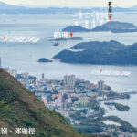
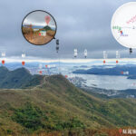
- Sunset Peak
- A famous spot for catching sunsets; the cluster of stone cabins near the ridge carries colonial-era history.
🐎 700–799 Metres
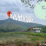
- Ma On Shan
- Shaped like a horse saddle and close to the new town; its distinct limestone geology nurtures various rare plant species.
🦁 500–699 Metres
- Lion Rock
- The spiritual anchor of Hong Kong, keeping watch over the entire Kowloon Peninsula.
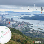
- Kowloon Peak
- Celebrated for its night views, offering a bird’s-eye view of Victoria Harbour and Kowloon City.
- Castle Peak
- The iconic landmark of Tuen Mun, offering exceptionally broad and vast fields of view.
—
🌿 Ecological & Geological Features
Category Description 🪨 Geology Predominantly composed of granite and volcanic rocks; certain mountain areas like Ma On Shan contain limestone deposits. 🌱 Vegetation Alpine meadows and subtropical forests that provide habitats for rare flora like the Hong Kong Azalea. 🦅 Fauna Birds of prey, wild boars, and squirrels are frequently sighted across mountain ranges; designated butterfly conservation areas are established in select regions. —
🏞️ Culture & Symbolism
Peak Name English Name Cultural Symbolism / Key Features 🦁 獅子山 Lion Rock The “Lion Rock Spirit”: Symbolising the resilience, grit, and unyielding perseverance of Hong Kong people. 🙏🏻 青山 Castle Peak A historical landmark of Tuen Mun, serving as a vital maritime navigation checkpoint in ancient times. 🐦🔥 鳳凰山 Lantau Peak A prominent spiritual hub of Buddhist culture, situated right next to Ngong Ping and the Tian Tan Buddha. —
🧭 Handy Tips
- MTR + Bus Combination is Most Convenient: The trailheads of most peaks can be directly accessed via public buses or green minibuses running from MTR stations.
- Budget Extra Time During Peak Seasons: Popular peaks like Lantau Peak and Sunset Peak see large crowds during autumn and winter; setting off early in the morning is highly recommended.
- Essential Safety Gear Required: For challenging, expert-level peaks like Sharp Peak, ensure you pack adequate water, food, and sun protection gear.