📡 【Radar Stations】 are the guardians of Hong Kong’s skies, strategically distributed across high mountains and vital coastal areas like Tai Mo Shan, Tate’s Cairn (Tai Lo Shan), and Sha Chau. They shoulder a dual mission: on one hand, operated by the Hong Kong Observatory (HKO) to monitor extreme weather such as typhoons, rainstorms, and thunderstorms; on the other hand, managed by the Civil Aviation Department (CAD) to safeguard aviation traffic control for Hong Kong International Airport (HKIA) and its flight paths. The site selection for these radar stations strictly adheres to the principle of “high altitude, wide coverage, and close proximity to the sea” to ensure comprehensive surveillance over Hong Kong and its adjacent airspace. Serving as both the HKO’s “meteorological eyes” and the CAD’s “airspace guardians”, their coverage spans hundreds of kilometres, playing a critical role in typhoon tracking, rainstorm forecasting, and aviation safety.
🏔️ Geographical Features
Category Representative Locations Geographical Features Core Function 🏔️ Mountain Advantage Tai Mo Shan, Tate’s Cairn, Mount Parker High altitude, minimizing terrain blockage, offering an expansive field of view Expanding surveillance range, ideal for long-range weather and en-route flight monitoring ✈️ Airport Proximity Tai Lam Chung, Tai Lam Kok, Siu Ho Wan Situated around Hong Kong International Airport Detecting low-level wind shear to secure aircraft take-offs and landings 🌊 Coastal & Islands Sha Chau Offshore location in the Pearl River Estuary Short-range approach monitoring, covering vital corridors for arriving and departing flights —Hong Kong’s radar network anchors on Doppler Weather Radars and Aviation Surveillance Radars as its core components. The former measures the velocity of raindrops to map wind fields, which is absolutely vital for estimating typhoon wind speeds; the latter monitors flight arrivals, en-route paths, and terminal control areas to ensure the safety of cross-boundary flights. Geographically, high-altitude hubs like Tai Mo Shan provide wide-area monitoring vistas, while coastal outposts like Sha Chau focus explicitly on flights entering Hong Kong airspace. Together, these sites form an intricate “airspace network” that allows Hong Kong to stay stable and safe amidst natural challenges and aviation demands.—
📡 HKO Radar Stations
- Tai Mo Shan
- Commissioned: 1999
- Function: Typhoon and rainstorm monitoring
- Slated to be upgraded to a “Dual-Polarization S-band Doppler Weather Radar”
- Tate’s Cairn (Tai Lo Shan)
- Existing Equipment: Dual-Polarization S-band Doppler Weather Radar
- Function: Monitoring weather over urban areas and the eastern region
- Tai Lam Chung & Tai Lam Kok
- Function: Detecting wind shear in the airspace near the airport
- Siu Ho Wan
- Features: Experimental X-band dual-polarization radar
- Function: Low-level wind shear monitoring
—
✈️ CAD Radar Stations
- Sha Chau
- Function: Approach Surveillance Radar
- Surveillance Range: Approx. 80 nautical miles
- Tai Mo Shan
- Function: Terminal Area Surveillance Radar
- Surveillance Range: Approx. 140 nautical miles
- Mount Parker
- Function: En-route Surveillance Radar
- Surveillance Range: Approx. 200 nautical miles
—
🌀 Technical Characteristics
Technology / Function Description Primary Application 🌧️ Doppler Principle Measures the velocity of raindrops to calculate wind fields Enhancing the accuracy of typhoon and rainstorm forecasts ❄️ Dual-Polarization Technology Distinguishes precipitation types such as rain, hail, and snow Improving severe weather monitoring and precipitation analysis ✈️ Aviation Safety Specialised in detecting low-level wind shear Preventing accidents during take-offs and landings, securing airport operations —
🌪️ Functional Focus
- Function CategoryDescriptionActual Role🌪️ Weather MonitoringReal-time tracking of typhoons, rainstorms, thunderstorms, and heavy downpoursProvides precise weather forecasts, supporting disaster prevention and public safety✈️ Aviation SafetyDetecting low-level wind shearSafeguards flight take-offs and landings at HKIA to prevent aviation accidents📡 Wide-area CoverageSpanning across the airspace of Hong Kong and the South China coastSupports cross-boundary en-route air traffic control, maintaining regional aviation order
—
🏔️ Geographical Site Selection Features
- Mountain Advantage:
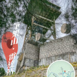
- Tai Mo Shan: The highest peak in Hong Kong at an elevation of 957 metres, offering an unobstructed view ideal for long-range Doppler weather radars.
- Tate’s Cairn (Tai Lo Shan): A mountain ridge in the eastern New Territories, serving as a backup radar station for Tai Mo Shan to ensure system redundancy.
- Coastal Distribution:
- Sha Chau: Situated offshore in the Pearl River Estuary, equipped with an Approach Surveillance Radar dedicated to monitoring flights safely entering Hong Kong airspace.
- Around the Airport:
- Siu Ho Wan and Tai Lam Chung: Specialised in low-level wind shear monitoring to protect flights arriving at and departing from HKIA.
- Eastern Hong Kong Island:
- Mount Parker: Equipped with an En-route Surveillance Radar covering long-range flight paths to ensure cross-boundary flight safety.
—
📡 Radar Technology & Functions
- Doppler Weather Radar
- Capable of measuring raindrop velocity and mapping wind fields, which is exceptionally critical for predicting typhoon intensities.
- The Doppler radars at Tai Mo Shan and Tate’s Cairn can detect rain zones, intensities, wind directions, and wind speeds within a range of several hundred kilometres.
- Aviation Surveillance Radar
- Sha Chau: Approach surveillance, providing short-range coverage.
- Mount Parker: En-route surveillance, providing long-range coverage.
- Tai Mo Shan: Terminal Control Area radar, providing medium-range surveillance.
—
📊 Summary of Major Radar Stations
Radar Station Geographical Location Function Surveillance Range Tai Mo Shan Highest peak in Hong Kong Doppler Weather Radar, En-route Surveillance Approx. 200 nautical miles (370 km) Tate’s Cairn (Tai Lo Shan) Mountain ridge in New Territories East Backup Doppler Weather Radar Approx. 256 km Sha Chau Offshore Pearl River Estuary Approach Surveillance Radar Approx. 64–80 nautical miles Mount Parker Mountain ridge in eastern Hong Kong Island En-route Surveillance Radar Approx. 200 nautical miles Siu Ho Wan Northern coast of Lantau Island Low-level wind shear monitoring Vicinity of the airport Tai Lam Chung Western New Territories Low-level airport surveillance Vicinity of the airport