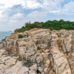
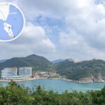
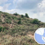
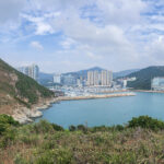
🌊 【Ap Lei Pai (鴨脷排)】 is a small, uninhabited island located in the Southern District of Hong Kong. Positioned directly south of Ap Lei Chau and north of Lamma Island, it sits right in the middle of the busy East Lamma Channel. Covering an area of roughly 0.092 square kilometers (about 23 acres), its highest point reaches an elevation of 68 meters at the summit of Ap Lei Pai. The island is completely unsettled and is famous for being connected to Mount Johnston (Yuk Kwai Shan) on Ap Lei Chau by a natural tombolo (a tidal sandbar) that emerges during low tide, allowing hikers to cross over on foot.
📌 Quick Facts
Item Details Administrative District Southern District Geographic Location South of Ap Lei Chau, north of Lamma Island, anchored in the center of the East Lamma Channel Surface Area Approx. 0.092 square kilometers (23 acres) Highest Peak Ap Lei Pai Summit, reaching roughly 68 meters above sea level Geology & Terrain Formed of tough volcanic granite; heavily sculpted by marine erosion into sheer sea cliffs, sea stacks, sea caves, and a natural rock arch known as the “Crab Cave” Access Condition Requires a favorable low-tide window to safely cross the tidal sandbar Classic Route Lei Tung Station ➝ Yuk Kwai Shan (Mount Johnston) ➝ Tidal Tombolo ➝ Ap Lei Pai Lighthouse Facilities Features a historic 8-meter-tall white lighthouse and a basic, rustic concrete landing pier at its southern tip Population 0 (Completely uninhabited) —
🚇 Transport & Access Guide
Method Route Description MTR + Trekking Take the MTR South Island Line to Lei Tung Station. Follow the rugged mountain trails to ascend and descend Yuk Kwai Shan, then cross the tombolo during a low tide window. The one-way trek takes about 2 hours. —
🥾 Classic Trekking Timeline
- Lei Tung Station to Yuk Kwai Shan Peak: Takes roughly 45 minutes. The trail hits a punishing 40-degree incline, featuring loose gravel sections where auxiliary ropes are installed.
- Yuk Kwai Shan to the Tidal Tombolo: Descending to the coast brings you to the sandbar. At low tide, the passable sand bridge widens to about 5 meters. It is strongly advised to cross strictly within 2 hours before or after the lowest tide.
- Ap Lei Pai Ridge & Lighthouse Section: A short, rocky trek across the island’s spine (peaking at 68m) leads directly to the southern tip. The iconic white lighthouse serves as the ultimate destination and turnaround point.
⚠️ Pro-Gear Check: High-traction trail shoes, durable scrambling gloves, and a reliable headlamp are absolute necessities. Never hike this route alone, avoid the typhoon season entirely, and always check the local Hong Kong Observatory tide charts before setting out.
—
📍 Photo Hotspots & Landmarks
- Ap Lei Pai Lighthouse: A beautiful, white cylindrical navigation tower facing the vast East Lamma Channel. It is a legendary hotspot for golden hour and sunset photography.
- Panoramic Ocean Vistas: The higher ridges offer stunning, unobstructed views looking out over Aberdeen Typhoon Shelter, Ocean Park, and the massive power station chimneys on Lamma Island.
- The Tidal Tombolo: A fascinating natural sand bridge formed over centuries by converging coastal wave currents.
- Sea Cliffs & Honeycomb Rocks: The northwestern coastline boasts rugged, wave-battered vertical rock faces and sea stacks that make for incredible wide-angle landscape shots.
- Yuk Kwai Shan Summit: Offers a striking visual juxtaposition between nature and civilization, contrasting the hyper-dense high-rises of Ap Lei Chau with the raw, barren wilderness of Ap Lei Pai.
—
⚠️ Safety, Law, & Eco-Etiquette
- Track the Tides: Crossing when the tide rises is extremely dangerous as water can wash completely over the sandbar, leaving hikers stranded or swept out to sea.
- Rugged Trail Conditions: The path down Yuk Kwai Shan is unofficial, unpaved, slippery, and exceptionally steep. Assess your fitness level carefully before attempting.
- Sampan Risks: While illegal, unlicensed water taxis (sampans) occasionally ply the waters near the lighthouse pier. Relying on them carries severe legal and safety risks; plan to hike back out the way you came.
- Leave No Trace: Pack out all your trash, absolutely no open fires are permitted, and avoid stepping on or disturbing the delicate marine life in the intertidal rock pools.
—
📝 Local History & Trivia
- The English name for Yuk Kwai Shan—Mount Johnston—was designated in honor of Alexander Robert Johnston, who served as Hong Kong’s temporary Deputy Governor during the early colonial era.
- Since the opening of the MTR South Island Line, foot traffic to this once-secluded outpost has surged dramatically, occasionally leading to chaotic situations where hikers get stranded by rising tides or over-reliant on unauthorized local boats.
—
📊 Feature Comparison
Feature Key Characteristic Critical Highlight Tidal Tombolo Natural sand bridge shaped by ocean currents Submerges completely during high tide windows Ap Lei Pai Lighthouse White cylindrical maritime navigation marker The lone structural landmark at the southern tip The Trail Terrain Slippery loose gravel, sharp crags, and steep scrambles Requires hands-on stability and excellent grip Scenic Overlooks Sweeping views of Lamma Island and Aberdeen Visibility is highly dependent on coastal fog and weather —
🌍 Key Geographical Terminology
English Term Traditional Chinese Geographical Description Tombolo 連島沙洲 A deposition landform where a spit of sand and gravel connects an island to the mainland during low tide. Ap Lei Pai Lighthouse 鴨脷排燈塔 An 8-meter-tall maritime navigation tower constructed in the 1960s to guide ships through the channel. Ap Lei Tsui 鴨脷咀 The rocky, outermost southern headland of the island where the lighthouse and concrete landing stand. Mount Johnston (Yuk Kwai Shan) 玉桂山 The highest peak on Ap Lei Chau, standing at 196 meters, serving as the intense gateway to the trek. East Lamma Channel 東博寮海峽 The deep water channel flanking the island, serving as a major international shipping lane for cargo vessels. Intertidal Landscape 潮間帶景觀 The dynamic coastal zone featuring rock pools, the Crab Cave arch on the east, and sea stacks on the northwest.