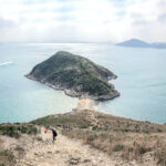
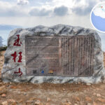
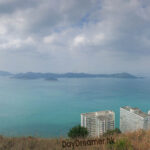
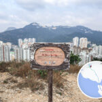
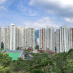
🏔️【Mount Johnston / Yuk Kwai Shan (玉桂山 – also known as Yuk Kwai Shan)】 is a coastal peak located in Ap Lei Chau within Hong Kong Island’s Southern District. Standing at 196 meters, it is the highest peak on the island of Ap Lei Chau. The English name “Mount Johnston” honors Alexander Robert Johnston, who served as the temporary Administrator of Hong Kong in the 19th century. Positioned in the southeastern part of Ap Lei Chau, the mountain connects to the islet of Ap Lei Pai, creating a striking “tombolo” landform. Mainly formed by volcanic rocks, the mountain features extremely steep slopes and is surrounded by the sea on three sides. It got its Chinese name from the wild cinnamon trees that used to grow all over the hills, and it still holds onto some of its native vegetation today. The sandspit between Mount Johnston and Ap Lei Pai appears and disappears with the tides. During low tide, you can trek across it to reach the Ap Lei Pai Lighthouse, making it a wildly popular adventure route for hiking enthusiasts. Along the way, you get a stunning 270-degree view looking down at Lamma Island, the Aberdeen Typhoon Shelter, and the vast South China Sea. —
📌 General Information
Item Details 🏔️ Chinese Name 玉桂山 (Mount Johnston / Yuk Kwai Shan) 📍 Location Eastern Ap Lei Chau, Hong Kong Southern District 🗺️ Coordinates 22°14′16.77″N, 114°9′24.1″E 🏞️ Elevation 196.2 m (644 feet) 🗻 Secondary Peak Fat Ye Mountain (also known as “Fake Yuk Kwai Shan”), 143 m above sea level 🏘️ Nearby Areas Lei Tung Estate, Yu On Court, South Horizons, Ap Lei Pai 🌉 Connected Places Ap Lei Pai — connected to Mount Johnston via the Ap Lei Pai • Tombolo —
🕰️ Historical Origin
- English Name Origin: “Mount Johnston” was named in honor of Alexander Robert Johnston, who briefly took charge as the Administrator of Hong Kong in 1841.
- Military Relics: In 1939, the British military built the “Aberdeen Battery” here to defend the waters around Lamma Island.
- Post-war Development: The eastern slope of the mountain used to be the Lei Tung Temporary Housing Area, which was later redeveloped into Lei Tung Estate.
—
— The hiking trails up Mount Johnston are famous for being seriously challenging. The traditional route starting from Lei Tung Estate requires hands-on scrambling up exposed rock faces, with some sections hitting a steep 60-degree incline. It is officially listed by the AFCD as a “high-risk hiking route.” While there are ropes installed along certain sections to help you up, many are old and weathered. Hikers often call it a mini version of Sharp Peak, grading its difficulty at 3.5 to 4 out of 5 stars. Thanks to the recent hiking craze, the paths have become heavily trodden and clearer, but loose gravel still makes it incredibly slippery, so bringing gloves and wearing shoes with solid grip is a must. The summit views are absolutely top-notch, letting you watch ships sail through the East Lamma Channel. Over on Ap Lei Pai to the southwest, you can explore WWII British pillbox ruins, adding a cool historical touch to the trek. You also get a full 360-degree view of Deep Water Bay, Ocean Park, and Lamma Island, and you can cross the tombolo straight over to Ap Lei Pai, where the lonely lighthouse and coastal rock formations are major hotspots for photos. —
🚍 Getting There & Away
Starting Point Transportation Lei Tung Estate Bus Terminus Bus: Routes 91, 96, 97, 98, 99 etc. take you straight to Lei Tung Estate. MTR Lei Tung Station South Island Line Lei Tung Station – Exit B, then walk about 10 minutes to reach the trailhead. Minibus Route 39M, starting from Tin Hau Station and passing through Yu On Court. —
🥾 Recommended Itinerary
- Total Distance: Around 4.5 km, taking about 2.5–3.5 hours.
- Suggested Route: Lei Tung Estate → Summit → Tombolo → Ap Lei Pai → Lighthouse → Return via the same way or head towards South Horizons.
- Starting Point: MTR Lei Tung Station Exit B or Lei Tung Estate Bus Terminus.
Path Difficulty Terrain Features Left Path ⭐⭐☆☆☆ The easiest option with gentler slopes, best for beginners. Middle Path ⭐⭐⭐⭐☆ The steepest route with tons of loose gravel. Requires hands-on scrambling; thick ropes are available to assist. Right Path ⭐⭐⭐⭐☆ Thrill-seeking and tricky with unstable footing, only suited for seasoned hikers. —
🕒 Trail Breakdown & Info
Item Details 📏 Distance Approx. 4–4.5 km ⏱️ Time Needed Approx. 2.5–3.5 hours ⚠️ Difficulty Moderate to High (⭐⭐項目☆☆ to ⭐⭐⭐⭐☆) 🧃 Supply Points Zero replenishment points along the way; must bring your own water and food. 🧤 Gear Tips Hiking shoes, gloves, hat, and sun protection. Exit Points No early exit options along the trail; you must turn back the way you came. 🌟 Quick Side Note: The Secondary Peak “Fake Yuk Kwai Shan”
Located to the west of Mount Johnston at about 143 meters high. It is often mistaken for the main peak, but it still offers great views and can be used as an alternative route. —
🏰 Historical Background
Mount Johnston was once a key military stronghold for the British forces defending the southern coastline:
- Aberdeen Battery: Built in 1939 to protect the southern coast. During the Battle of Hong Kong in WWII, it was intentionally destroyed by the defending garrison to prevent it from falling into the hands of the Japanese army.
- Post-war Development: The eastern slope of Mount Johnston was once the Lei Tung Temporary Housing Area, which was later torn down and rebuilt into Lei Tung Estate.
—
🏞️ Attractions & Scenic Features
Location English Name Features Summit Trigonometrical Station Trigonometrical Station The classic milestone for reaching the peak. Set against a dramatic backdrop, it offers a stunning 360-degree ocean view looking out to Lamma Island, Brick Hill (Nam Long Shan), Ocean Park, and down over the Aberdeen Typhoon Shelter. Ap Lei Pai • Tombolo Tombolo A completely natural sandbar connecting Mount Johnston to Ap Lei Pai. Ap Lei Pai Lighthouse (Mount Johnston • Lighthouse) Ap Lei Pai Lighthouse Perched at the southern tip of Ap Lei Pai. It is linked by a natural tombolo about 200 meters long that you can walk across during low tide. Offers incredible coastal scenery and absolute killer sunset views. Aberdeen Battery Aberdeen Battery Built in 1939 as part of the WWII coastal defense network. —
⚠️ Important Safety Tips
- The trail is incredibly steep with lots of loose dirt and gravel; slipping hazards are very high.
- It gets scorching hot in the summer and there is zero shade on the mountain, making heatstroke a real risk.
- Highly recommended to go with an experienced hiker, especially if it is your first time checking it out.
- Since the paths are steep and require a fair bit of scrambling, make sure you wear proper hiking shoes and bring along gloves.
- The built-in ropes are severely worn out; do not rely on them for your safety.
- There are no official kaido ferry services near the Ap Lei Pai Lighthouse (Mount Johnston • Lighthouse), so it is best to head back the way you came.
—
🔎 Further Exploration
If you are looking for a complete step-by-step hiking guide, feel free to check out 《 Mount Johnston • Daydreamer 》. —