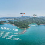
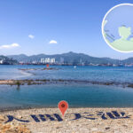
🗺️ 【Cheung Pai Tau (長排頭)】 is a coastal cape extending into the Sha Tau Kok Hoi (Starling Inlet) in the northeastern New Territories of Hong Kong. Together with nearby capes like Cheung Shek Tsui, Sam Ko Tsui, Kei Shan Tsui, and Ah Kung Tsui, it forms part of a famous coastal collective known as the “Five Capes of Sha Tau Kok”. Tucked away along Hong Kong’s remote northeastern frontier, reaching this hidden gem typically requires a grueling trek of 15 kilometers or more, involving tricky coastal rock-scrambling (coastal coasteering) and dense jungle bushwhacking. As a result, it sees very few visitors, maintaining a remarkably secluded and tranquil atmosphere. —
📌 Quick Facts
Category Details 📍 Location Northeastern shore of Sha Tau Kok, New Territories; recognized as one of the “Five Capes of the Northeast.” 🌐 Topography A natural tombolo feature featuring an oval-shaped tidal pool known as the “Heavenly Pool,” which creates a flawless “mirror of the sky” effect at low tide. 🌿 Ecosystem An untouched, primitive natural environment rich in mangrove swamps, wetlands, and vibrant intertidal biodiversity. 🥾 Hiking Route Typically starting from Luk Keng → Tiu Tang Lung Path → Yung Shue Au → Cheung Pai Tau. Spanning roughly 17–18 km, this trek demands excellent physical stamina. 🧭 Difficulty ★★★★☆ (Advanced: Requires technical coastal rock-hopping, jungle navigation, and strict tidal monitoring). 🕒 Duration Approx. 6 hours (highly dependent on individual fitness and coastal conditions). 🏞️ Nearby Points Lai Chi Wo, Kuk Po, Fung Hang, Ap Chau, and Kat O. 🚦 Landmarks Cheung Pai Tau Lighthouse, Heavenly Pool (tidal pool). 🚍 Transport Start: Green Minibus 20C/20R (Tai Po Market Station ↔ Wu Kau Tang).
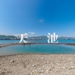
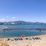
End: Green Minibus 56K (Luk Keng ↔ Fanling Station).⚠️ Cautions Expect dense, overgrown brush and significant tidal changes. Wearing long pants is highly recommended, and checking the Hong Kong Observatory’s tide charts before setting off is mandatory. — The absolute crown jewel of Cheung Pai Tau’s natural scenery is a rock-bound tidal basin right along the shoreline affectionately dubbed the “Heavenly Pool.” During low tide, this pool completely disconnects from the open sea. When the winds are calm, the water surface turns into a flawless mirror that perfectly reflects the passing clouds and blue skies, creating a dreamscape for landscape photographers. Capturing this phenomenon requires careful planning around the tides; during high tide or spring tides, the pool is completely swallowed up by the sea. A small, rustic white lighthouse stands watch on the cape, adding a beautiful focal point to the rugged coastal horizon. —
🌊 The Heavenly Pool: The Soul of Cheung Pai Tau
The definitive landmark of Cheung Pai Tau is its perfectly oval, natural tidal rock pool. When the tide drops away, the water turns into a perfect, glass-like sheet reflecting the sky. 📸 Photography Tip: The ultimate shooting window is 1 to 2 hours after a falling tide, ideally when the regional sea level drops below 1.5 meters. —
—
🧭 Geography & Coastal Formations
- Location: Nestled along the remote northeastern coast of Sha Tau Kok, directly facing San Kau Po Kok across the inlet.
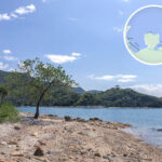
- Terrain: It is functionally a tombolo (a sand spit connecting an island to the mainland), making it accessible on foot during low tides. The terrain is flat but heavily ringed by jagged rocks and thick mangrove flats.
- The Pool: An oval rock basin carved out by the tides. Its stunning mirror-like reflections at low tide have turned it into a bucket-list sanctuary for local landscape photographers.
—
🌿 Ecosystem & Wilderness
- Mangrove Swamps: Pockets of flourishing mangroves line the sheltered shores, providing a rich breeding ground for coastal waterbirds and wetland organisms.
- Intertidal Biodiversity: The rock pools are teeming with life; you can easily spot mudskippers, scuttling fiddler crabs, and clusters of marine mollusks.
- Pristine State: Thanks to its sheer isolation, it remains entirely untouched by urban development, offering a rare look at natural shoreline evolution.
— Treks to Cheung Pai Tau usually launch from either Wu Kau Tang or Luk Keng, charting a path through historically abandoned Hakka villages like Lai Chi Wo and So Lo Pun before reaching the cape. Spanning 15 to 18 kilometers, this 5-to-7-hour trek involves intense bushwhacking through dense brush and balancing across slippery coastal boulders, making it suitable only for experienced hikers with solid physical endurance. Because the route is deeply isolated, mid-trail supply points are non-existent; you will have to rely entirely on the small village stores (village stores) located at the very start or end of your journey (such as those in Wu Kau Tang, Lai Chi Wo, or Luk Keng). Coming fully prepared with off-line navigation maps, plenty of food, adequate water supplies, protective gear, and a clear grasp of the daily tide schedule is essential. —
🚍 Transportation Guide
Location Transport Logistics & Routes Wu Kau Tang Green Minibus 20R: Operates between Tai Po Market Station ↔ Wu Kau Tang. Luk Keng Green Minibus 56K: Runs between Luk Keng ↔ Fanling MTR Station. Lai Chi Wo Weekend/Holiday Ferry: Sails from Ma Liu Shui or Yim Tin Tsai (booking ahead is highly recommended). —
📸 Trail Highlights & Scenic Stops
Scenic Spot Key Highlights Heavenly Pool Breathtaking sky-mirror reflections; a dream location for photography. Yung Shue Au Dam Atmospheric ruins of an abandoned Hakka border village. Ap Chau & Kat O Vistas Sweeping, panoramic views across the open sea toward remote offshore islands. Fung Hang Pier A small, picturesque lighthouse brimming with traditional fishing village charm. —
🎒 Recommended Packing Checklist
- 🧢 Sun hat and UV-protection sunglasses
- 🥾 Rugged hiking boots with deep, non-slip tread
- 🧴 High-SPF sunscreen and heavy-duty insect repellent
- 📱 Reliable offline maps or a GPS-enabled sports watch
- 🧃 Ample drinking water (at least 2–3L) and high-energy trail snacks
- 🧤 Tough hiking gloves (essential for grabbing rocks and scrambling through thick brush)
—
⚠️ Essential Hiking Tips & Guidelines
- 🌊 Timing is everything: Always cross-reference your trip with the Hong Kong Observatory Tide Forecast. Getting caught by a rising tide can leave you completely stranded along the rocky coast.
- 🧭 Download offline maps: Many sections of these faint wild trails are not marked on standard online maps. Take screenshots and keep a backup power bank handy.
- 🧵 Don’t blindly rely on ribbons: While trail ribbons left by previous hikers are helpful, they can easily deteriorate, break off, or lead down dangerous, outdated routes. Always trust your GPS and map data first.
- 🌿 Protect your skin: The brush along the coast is incredibly sharp and overgrown. Wear long-sleeved shirts, durable long pants, and bring a trekking pole to clear cobwebs and steady your balance.
- 📸 Plan for the low tide: If your goal is photographing the Heavenly Pool, look for dates that feature exceptionally low spring tides during daylight hours.
—
‼️ Major Risks to Keep in Mind
- 🌊 Tidal Traps: The coasteering stretches must be completed during a low tide window. If the sea level reads above 1.5 meters, the Heavenly Pool will disappear beneath the waves, and the shoreline rocks will become impassable.
- 🌲 Dense Bushwhacking: This is an unofficial, unmaintained route that requires pushing through thick undergrowth (“bushwhacking”). Never attempt this alone; ensure you are accompanied by someone well-versed in backcountry navigation. If you lose the trail, retrace your steps immediately to your last known marker.
- 🚫 Zero Solo Hiking: Because of its extreme remoteness, cellular reception along the coast can be non-existent. Always hike in a group and explicitly inform family or friends of your exact route and expected return time.
—
🌅 Extended Exploration Ideas
- 🏝️ Kat O & Ap Chau: Enjoy sweeping views of these unique, far-flung northern islands set against brilliant turquoise waters.
- 🧭 Sam Ko Tsui & San Kau Po Kok: Discover fascinating, deeply weathered coastal rock formations and unique geological features.
- 🏡 Kuk Po & Fung Hang Villages: Popular eco-tourism stops in the northern New Territories, showcasing well-preserved Hakka culture and peaceful reed beds—perfect for a mid-hike break.
- 🪵 The Hollow Tree of Lai Chi Wo: A famous old autumn maple tree with a completely hollowed-out center, perfect for exploring and photography.
- 🏚 Yung Shue Au Village: A ghost village swallowed up by the jungle, preserving original Hakka brick architecture and historic village structures.
—