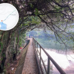
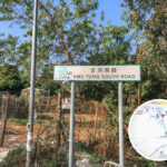
🛣️ 【Kwu Tung South Road (古洞南路)】 is a rural road in the Kwu Tung area of the North District, New Territories, Hong Kong. It connects the Kwu Tung Market with the Kwu Tung Reservoir and service reservoir. Shaded by trees along the way, this tranquil path serves as the primary route to the highly popular hiking and social media hotspot “Kwu Tung Reservoir” (famously dubbed Hong Kong’s “Heart-shaped Lake” because it resembles a heart when looked down upon). Starting from the Kwu Tung Market, a short and easy 10-to-15-minute walk along the flat concrete road brings you straight to the reservoir. Thanks to this quick, hassle-free outdoor access, it pulls in crowds of locals and tourists alike. —
📍 Location & Route Breakdown
📌 Item 📋 Details 🏞️ District Located in the Kwu Tung sector of the North District, New Territories; close to Sheung Shui and Fanling, falling within the planning boundaries of the Northern Metropolis 🚩 Starting Point Kwu Tung Market crossroads 🏁 Terminus Kwu Tung Reservoir entrance 📏 Length Approx. 800 meters, taking roughly 10–15 minutes on foot 🔗 Connected Areas Ki Lun Shan, Sheung Yue River (River Beas), Pak Shek Au 🗺️ Geographical Scope Bounded by Fanling Highway to the north, Lam Tsuen Country Park to the south, Ki Lun Shan to the west, and the Hong Kong Golf Club to the east 🌳 Natural Environment Rich in natural resources, featuring rivers, hills, and farmlands with immense ecological conservation value 🗺️ Geographical Location & Boundaries
Kwu Tung South Road sits in the southern part of the Kwu Tung area within the North District of the New Territories, nestled between Pak Shek Au and Ki Lun Shan. This road primarily extends south of Castle Peak Road (Kwu Tung section), running through several local villages and residential neighborhoods.
- Northern Border: Kwu Tung Market
- Southern Border: Pak Shek Au Interchange
- Western Border: San Tin Interchange
- Eastern Border: Hang Tau Village
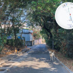
— Kwu Tung South Road is more than just a gateway for hikers; it is also surrounded by traditional rural landscapes and natural habitats. Passing right through Kwu Tung’s villages and farmlands, walkers can spot common countryside trees and fruit trees like large camphor trees, lychee, and longan, alongside other flora like rose myrtle and incense trees. Furthermore, according to surveys by the Hong Kong Bird Watching Society, the nearby Long Valley wetlands have recorded over 310 species of birds—accounting for half of Hong Kong’s total bird species—including 20 globally threatened species, making the area a prime viewing spot for nature lovers. —
🌳 Ecology & Natural Landscapes
- Kwu Tung Reservoir
Famously nicknamed the “Heart-shaped Lake,” this spot has become a trending destination for photos in recent years. The water surface forms a heart shape ringed by dense woods. It was originally built for agricultural irrigation.- Ki Lun Shan
Boasting a well-developed network of mountain trails, it links up to Kam Tin, Pat Heung, San Tin, Mai Po, and Fung Ying Seen Koon, making it a must-visit for avid hikers.- Sheung Yue River (River Beas)
Hikers can catch views of this river along Kwu Tung South Road. The riverbanks are bursting with life, making it easy to spot little egrets, dragonflies, and various aquatic plants.—
— Getting to Kwu Tung South Road is quite straightforward. You can catch green minibus 50A or KMB bus 76K from Sheung Shui MTR Station and get off at the “Kwu Tung Market” stop, which puts you right at the starting point. Keep in mind that vehicles occasionally drive up and down Kwu Tung South Road, and village dogs roam near some of the village houses, so it’s a good idea to hike with friends and avoid bothering the animals. All in all, with its easy accessibility and its perfect blend of rural charm, nature, and scenic hotspots, Kwu Tung South Road offers a great, laid-back escape from city life. —
🚍 Transport Network & Connections
Kwu Tung South Road serves as a vital corridor linking Fanling and Yuen Long. Available transit options include:
- KMB Route 76K: Runs between Sheung Shui and Yuen Long, stopping at the Kwu Tung Market station.
- New Territories Green Minibuses:
- 50K: Sheung Shui ↔ Hang Tau
- 51K: Sheung Shui ↔ Ho Sheung Heung
- 50A: Kwu Tung Market ↔ Yuen Long
Key Interchanges:
- Pak Shek Au Interchange: Feeds directly into the Fanling Highway.
- San Tin Interchange: Provides heavy vehicle access heading toward the Huanggang Port in Shenzhen.
—
🌄 Natural & Cultural Attractions
The area surrounding Kwu Tung South Road is packed with rich natural resources and heritage landmarks:
- Kwu Tung Reservoir: Tucked inside Ki Lun Shan, this irrigation reservoir features a heart-shaped shoreline, making it a huge favorite for hikers and photographers.
- Sheung Yue River (River Beas): Flowing through Kwu Tung South, its scenic riverbanks are a common sight for passing hikers.
- Yan Wah Lo: A historic study hall built by the Yeung family, who were Indonesian Chinese, located in the Yin Liu Area (Tobacco Shed District).
- Lady Ho Tung Welfare Centre: A historic building that stands as a testament to the early development of medical services in Kwu Tung.
—
🏘️ History & Community Development
- Europa Garden
Built in 1995, this was the earliest low-density residential development project in Kwu Tung South.- Valais
Completed in 2009, this sprawling luxury residential estate features architectural styles that blend European and modern elements.- Kwu Tung North New Development Area
- Planned to house a population of over 100,000.
- Will feature Kwu Tung Station on the MTR Northern Link.
- Includes public housing projects, commercial districts, and community amenities.
- Kwu Tung South Road will be upgraded to a major thoroughfare, linking the new town with Sheung Shui and Yuen Long.
—
🚶♂️ Hiking Tips & Transportation Advice
Hiking Route (Starting from Kwu Tung Market)
- Start: Kwu Tung Market (accessible via KMB 76K).
- Walk along Kwu Tung South Road → pass through Cheung Lek Village → head along the Sheung Yue River bank.
- Arrive at Kwu Tung Reservoir → choose to scale Ki Lun Shan or head back.
Important Reminders
- The road is narrow and lacks formal pavements, so watch out for traffic.
- There are no replenishment stops along the trail; remember to bring your own water and sun protection.
- Best enjoyed during autumn and winter, as mosquitoes and insects can be quite heavy during summer.
🏞️ Highlights
📍 Highlight ✨ Features 💖 Heart-shaped Lake A heart-shaped shoreline, perfect for photography📸 and picnics🍱 ⛰️ Ki Lun Shan Peak Offers panoramic views of the northern New Territories🌆, with spectacular sunset vistas🌇 🏞️ Sheung Yue River Bank Perfect for jogging🏃♂️, bird watching🐦, and photography📷 🗺️ Pak Shek Au Trails extend further out toward Lok Ma Chau, Man Kam To, and beyond🚶♀️ —
🏞️ Cultural & Historical Footprints of Kwu Tung South
- The name “Kwu Tung” carries deep historical roots, originating from ancient records noting that “Dung is where the ancient southern tribes live.”
- After 1945, it became a melting pot for Weitou, Hakka, and Teochew communities, resulting in the formation of various squatter villages.
- The Kwu Tung section of Castle Peak Road was once a thriving market street, though it gradually quieted down as modern new towns developed.
—
🚧 Future Outlook & Challenges
- Kwu Tung South Road will undergo widening and major upgrades to support the rollout of the Kwu Tung North New Town.
- Striking a balance between green conservation and urban expansion will be vital to prevent damage to the native natural ecosystem.
“`