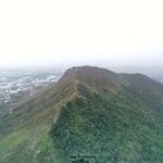
🐲 Ki Lun Shan (also known as Hadden Hill) is a hill located in the North District of the New Territories, standing at an elevation of about 223 metres. Situated close to Kwu Tung, it is a relatively tranquil spot that offers sweeping views stretching as far as Shenzhen and Mai Po. The Kwu Tung Service Reservoir sits within the Ki Lun Shan area, and the surrounding hillsides are dotted with a few abandoned military structures, adding a touch of historical intrigue to the landscape. —
📌 Quick Info
Item Details 🏞️ Mountain Name Ki Lun Shan (also known as Hadden Hill) 📍 Location West of Kwu Tung, North District, New Territories, Hong Kong; right next to Tai Lo Tin and Ngau Tam Shan 📏 Elevation Approx. 222 metres 🗺️ Terrain Features Hilly terrain with clear ridgelines and a hilltop trigonometrical station. It is part of the Kai Kung Leng mountain range, connecting to Ngau Tam Shan and Tai Lo Tin. The landscape undulates but isn’t overly steep. 🌄 Landscape Highlights The summit enjoys completely unobstructed, panoramic views. Hikers can look down at the heart-shaped Kwu Tung Reservoir and look out across the Mai Po fishponds, Lok Ma Chau, Tai Lo Tin, and Kai Kung Leng. 🌿 Vegetation & Environment Thick brushwood with minimal shade along certain stretches. Silvergrass blankets the slopes in autumn and winter, while summers can get intensely hot. 🐾 Suggested Route Kwu Tung Market → Kwu Tung Service Reservoir → Ki Lun Shan → Ki Lun Shan Au → Minibus Stop ⏱️ Duration Around 2–2.5 hours, depending on your fitness level and photo stops 📐 Distance Approx. 3.5–4 km 🔥 Difficulty Rating ⭐️⭐️⭐️☆☆ (Moderate; some sections have dense overgrowth and follow unofficial trails) 🏛️ Historic Relics World War II relics, including trenches and defensive fortifications, can be spotted along the way. 🧭 Surrounding Mountain Links Connected to Ngau Tam Shan (337m) and Kai Kung Leng (550–585m). This range belongs to the mountains traditionally named after the mythical “Nine Sons of the Dragon”. —
🐉 Origin of the Name & Cultural Meaning
- Ki Lun Shan (Qilin Mountain), Ngau Tam Shan (Ox Pond Mountain), and Lung Tam Shan (Dragon Pond Mountain) are all named after Chinese mythical creatures.
- Legend has it that “Ao”—one of the nine sons of the dragon featuring a dragon’s head, a turtle’s body, and a Qilin’s tail—symbolises the continuity and cultural depth of these interconnected ridges.
—
— Getting to Ki Lun Shan is pretty straightforward. You can start from Sheung Shui MTR Station, catch green minibus 50A to Kwu Tung Market, and then head up on foot. There are signs along the path directing you up toward the service reservoir and the summit. Though Ki Lun Shan isn’t particularly tall, its natural, rugged environment makes for a rewarding hike. Standing at the top, you can gaze down at the Kwu Tung Reservoir and soak in a peaceful escape far from the city’s hustle and bustle. All in all, it is an awesome choice for anyone looking for a short hike to reconnect with nature. —
🚍 Transport Info
Mode of Transport Route / Stop Bus KMB 76K: Ching Ho Estate ↔ Long Ping Estate (Get off at Kwu Tung Market Stop) Minibus 50A: Sheung Shui Station ↔ Kam Tsin Village
605: Ki Lun Tsuen ↔ Sheung Shui Station—
🥾 Detailed Hiking Route
🚶♂️ Starting Point: Kwu Tung Market
- Transport Options:
- KMB 76K (Ching Ho Estate ↔ Long Ping Estate)
- Green Minibus 50A (Sheung Shui Station ↔ Kam Tsin)
- Pit Stops: The market features local stores and public toilets, making it the perfect spot to stock up on water and snacks before heading up.
🏞️ Section 1: Kwu Tung Market → Kwu Tung Reservoir
Location Description & Features Kwu Tung South Road The warm-up stretch; follow the paved road for about 5 minutes. Kwu Tung (Sui Tong Hang) Public Toilet The very last restroom facility before tackling the mountain trail. Kwu Tung Reservoir The iconic heart-shaped lake photo spot. The main dam offers gorgeous views where the glassy water beautifully mirrors the surrounding hills. 📸 Photo Tip: Turn left at the end of the dam and follow the lakeside path to get an up-close, clear shot of the heart-shaped reservoir.
⛰️ Section 2: Kwu Tung Reservoir → Ki Lun Shan Summit
- Head back to the “Y” fork and take the upper right slope, passing the Kwu Tung Service Reservoir.
- Follow the mountain path running right alongside the reservoir’s chain-link fence. Trail conditions to note:
- The initial climb is covered in loose gravel and sand, so wearing proper hiking shoes is highly recommended.
- You will catch glimpses of wild silvergrass and old concrete ruins along the path.
- It takes about 1 hour to reach the summit.
📍 Summit Panorama:
- Looking West: Deep Bay (Houhai Bay) and the Shenzhen Bay Bridge.
- Looking North: The bustling downtown skyline of Futian, Shenzhen.
- Looking South: The Mai Po Marshes and San Tin fishponds.
🧭 Section 3: Ki Lun Shan → Ki Lun Shan Au → Ki Lun Tsuen
Trail Stretch Features & Advice Ki Lun Shan West Cliff A popular photo spot that looks straight down at the border landscapes of the northern New Territories. The Descent The most challenging part of the hike. It is heavily covered in loose gravel and sand; take it slow or slide down carefully. Ki Lun Shan Fresh Water Service Reservoir Nearing the end of the trail, you’ll find a fork in the path that can lead you toward Ngau Tam Shan. Ki Lun Shan Au From here, you can catch minibus 605 back to Sheung Shui Station, or walk over to the Ki Lun Tsuen pavilion to wait for your ride. —
💧 Kwu Tung Reservoir & the “Heart-Shaped Lake”
- Capacity: Roughly 50,000 cubic metres, built entirely for irrigation purposes.
- Nicknames: “The Hong Kong Version of Heart Lake” and “The Mirror of the Sky”.
- Best Angles: For the absolute clearest look, shoot from the middle slopes of Ki Lun Shan or up on the West Cliff.
- Features: The exceptionally calm water creates crisp, perfect reflections, making it a dream for photography lovers.
—
🌾 Summit Views & Natural Highlights
- Silvergrass: During autumn and winter, the summit gets blanketed in golden silvergrass, offering a truly magnificent sight.
- Rock Formations: The hilltop exposes layers of quartzite, with shell fossils embedded in certain rocks.
- Military Relics: The mid-slopes house abandoned tunnels and structures once used by the British military, which now lie completely ruined.
- Wildlife & Plants: The trail is teeming with biodiversity, where you’ll frequently spot butterflies, lizards, and wild blossoms along the way.
—
⚠️ Quick Tips & Safety Advice
- 🥤 There are absolutely no supply points along the trail, so pack plenty of water and energy snacks.
- 🐕 You might cross paths with village dogs near Kwu Tung Reservoir, so stay alert and keep your distance.
- 🌿 The paths are heavily overgrown with long grass; wearing long trousers is smart to prevent getting scratched.
- 🧼 The slopes are thick with loose scree and sand; slipping is easy without non-slip hiking shoes.
- 📵 Since this is an unofficial hiking route, make sure to use a reliable GPS map app or a physical paper map.
- 🧭 If it’s your first time tackling this hill, it is highly recommended to hike with a buddy.
—
🧭 Extended Hiking Ideas
- Ngau Tam Shan (offers spectacular vistas looking north toward Shenzhen).
- Long Valley Wetland (a stunning ecological conservation zone).
- San Tin & Lok Ma Chau (ideal for capturing rustic border scenery).
—