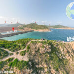
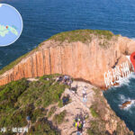
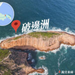
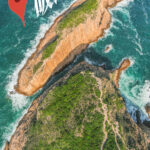
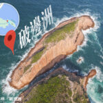
🌋【Po Pin Chau (破邊洲 – Geological Wonder × Hidden Hiking Spot)】 is one of the core landmarks of the Hong Kong UNESCO Global Geopark, located off the coast of Sai Kung East Country Park near the High Island Reservoir • East Dam. This sea stack cluster was once part of Fa Shan, but after long-term erosion and weathering, it separated from the mainland to form independent rock columns. Its name vividly reflects the “broken coast” feature. These towering hexagonal columns, formed about 140 million years ago during the Jurassic volcanic eruptions, are acidic rhyolitic volcanic rocks with clear geometric joints, regarded by scholars as a rare geological marvel worldwide.
—
📌 Basic Information
Category Details 🏝 Name Po Pin Chau(破邊洲) 📍 Location Sai Kung District, Hong Kong New Territories, off High Island Reservoir • East Dam, part of the Shuen Wan coastline 🌋 Geological Formation Formed about 140 million years ago during late Jurassic volcanic eruptions, lava cooling created hexagonal basalt columns 🧱 Landform Features Hexagonal column clusters, sea stacks, sea caves, sea arches, organ pipe cliffs, steep escarpments, pebble beaches 🧭 Original Terrain Originally part of Fa Shan headland, separated into an island due to erosion and weathering 🧭 Geological Classification Representative landmark of Hong Kong UNESCO Global Geopark’s Sai Kung Volcanic Rock Region 📏 Island Scale Approx. 200m long, 100m wide, 63m high 📸 Famous Spots Cross Viewpoint, Hong Kong’s Heart (Heart-shaped Valley), Kim Chu Wan, Thousand Pillar Coast, Concubine Pool 🚶♂️ Hiking Route Start: High Island Reservoir • East Dam → Fa Shan Viewpoint → Cross → Kim Chu Wan, total 2–3 hrs 🚌 Transport Minibus 9A (weekends/holidays), taxi (Sai Kung town to East Dam ~HK$150) 🕒 Best Season Open year-round, best photo time before 10am to avoid backlight 🧪 Scientific Value Demonstrates volcanic activity, magma cooling, crustal uplift, and marine erosion processes; evidence for studying cooling rates of volcanic rocks ⚠️ Safety Tips No railings at cliffs, steep sections, beware of strong winds, climbing columns prohibited These columns align like organ pipes, comparable to Iceland’s black sand beach and Northern Ireland’s Giant’s Causeway.
—
【Po Pin Chau】’s scenery is dramatic: sea arches, cliffs, and azure waters form breathtaking views. The “Eye of God” sea cave glows mysteriously blue under certain light. The area is ecologically rich, with sea urchins and crabs in the intertidal zone, and white-bellied sea eagles often soaring above. Due to steep cliffs and strong waves, climbing is strictly prohibited, but visitors may view from sightseeing boats or coastal trails during low tide.
—
🔬 Geological Background & Formation
Aspect Description 🔥 Volcanic Activity About 140 million years ago, massive eruptions released lava and ash. 🧊 Cooling Contraction Lava cooled and contracted, forming vertical joints and hexagonal basalt columns. 🌊 Marine Erosion Long-term wave erosion collapsed Fa Shan’s headland, leaving isolated stacks. 📏 Scale Column cluster ~200m long, 100m wide, 63m high, organ pipe-like alignment. —
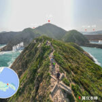
🌟 Must-see Spots
🧱 Hexagonal Columns
- Globally rare geological structure, comparable to Iceland and Giant’s Causeway.
- Columns ~1.2m diameter, aligned vertically forming majestic cliffs.
💔 Hong Kong’s Heart
- Kim Chu Wan valley shaped like a heart.
- Best seen from above or aerial photography.
✝️ Cross Viewpoint
- Overlooks Po Pin Chau and Concubine Pool.
- Perfect for sunrise and coastline shots.
🪨 Kim Chu Wan
- Distinct sea-eroded landform with pebbles and hexagonal columns.
- Strong waves, caution advised when taking photos.
—
🥾 Hiking Routes
🔹 Fa Shan Route (Intermediate, 3–4 hrs)
- Start: High Island Reservoir • East Dam (Minibus 9A terminus)
- Route: East Dam → Fa Shan → Cross → Kim Chu Wan → Hong Kong’s Heart → Po Pin Chau Viewpoint
- Features: stone steps, ropes, close-up views of columns, cliffside safety required
🔸 Pak Lap Route (Advanced, 5–6 hrs)
- Start: Pak Lap Village
- Route: Pak Lap → Wong Ngau Wan → Kim Chu Wan → Fa Shan → Po Pin Chau
- Features: dense scenic spots, challenging terrain, suitable for experienced hikers, boat transfer back to Sai Kung possible
—
🚗 Transport Overview
Mode Details 🚌 Minibus 9A Pak Tam Chung ↔ High Island Reservoir • East Dam (Sundays & Public Holidays only, 09:30–19:00) 🚕 Taxi Sai Kung to East Dam ~HK$150; from Sha Tin ~HK$250 🚌 Bus Transfer From Diamond Hill take 96R or from Sai Kung take bus 94 to Pak Tam Chung, then transfer to minibus or taxi ⛵ Hired Boat Charter boats available from Sai Kung Pier direct to Pak Lap or Po Pin Chau (advance booking required) —
⚠️ Safety & Environmental Tips
- 🚫 Kim Chu Wan trail is extremely steep, not recommended for beginners
- 🥾 Wear non-slip hiking shoes, bring at least 2L of drinking water
- 🌬️ Strong winds near cliffs, avoid standing close to edges when taking photos
- 🗑️ Carry garbage bags, take all trash away
- 🧱 Climbing columns strictly prohibited to protect geological heritage
—
🧠 Geological Scientific Value
- Demonstrates volcanic eruptions, magma cooling, crustal uplift, and marine erosion processes
- Hexagonal joints provide evidence for cooling rates and crustal stress changes
- S-shaped twisted structures record tectonic stress variations
- Volcaniclastic layers help reconstruct Jurassic paleogeography
—