There are two major locations named 👨🏼🦳 【A Kung Kok (亞公角)】 in Hong Kong: one is situated in the Sha Tin District (A Kung Kok, Sha Tin), while the other lies within Robin’s Nest Country Park in the northeastern New Territories (A Kung Kok, Robin’s Nest). The former is well-known for its unique fishermen’s resettlement village and urban infrastructure, whereas the latter stands out as an ecological corridor rich in border history and wartime relics.
🏘️ A Kung Kok in Sha Tin District
Located in the northeastern portion of the Sha Tin District, this coastal area was historically a settlement for local fishing communities. Following extensive new town land reclamation, the seafaring residents moved ashore in 1983 into the purpose-built A Kung Kok Fishermen Village. Today, the village actively preserves the traditional Tai Wong Yeh Temple and seasonal dragon boat racing customs, representing a vibrant continuation of their maritime heritage. Modern-day A Kung Kok features crucial community landmarks such as Shatin Hospital and the Tate’s Cairn Highway, serving as a vital transport and lifestyle hub that showcases cultural adaptation amid rapid urban growth.
Category Detailed Description 📍 Geographical Location Nestled between Ma On Shan and Shek Mun, adjacent to Shatin Hospital, and forming an integral sector of Sha Tin New Town. 🏡 Fishermen Village A Kung Kok Fishermen Village was established by government planners in 1983, consisting of 62 village houses. The residents mainly originated from the old coastal A Kung Kok village, Yui Shui Pai, and Ho Tung Lau. Historically Hoklo fishermen, they previously cast nets around Wo Che and Lok Lo Ha. As Sha Tin’s reclamation progressed, they were resettled ashore, and their traditional fishing industry gradually faded. The village houses the Tai Wong Yeh Temple and passes down its seafaring heritage through annual Dragon Boat Racing traditions. buses Transport & Facilities A Kung Kok Street and A Kung Kok Shan Road serve as the primary traffic arteries. It hosts the Green Minibus 67K Terminus, providing direct connectivity between Sha Tin Town Centre and Ma On Shan. The area accommodates Shatin Hospital and borders the Tate’s Cairn Highway, making it an essential transport crossroad for the new town. —
🌿 A Kung Kok in Robin’s Nest Country Park
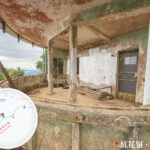
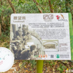
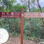
Deep within the rolling hills of Robin’s Nest in the northeastern New Territories, another locality shares the name A Kung Kok. This remote area forms a crucial part of a cross-border ecological corridor. In spring, wild red azaleas burst into bloom across the ridges, while massive bat colonies roost in the nearby Lin Ma Hang Lead Mine Cave. The hillsides also provide a rare sanctuary for the Marsh Grassbird (Locustella pryeri). Beyond its exceptional biodiversity, the landscape preserves World War II-era machine gun posts and Cold War-era MacIntosh Forts, establishing this A Kung Kok as a unique destination where conservation meets military history.
Category Detailed Description 📍 Location Situated in Sha Tau Kok in the northeastern New Territories, occupying the southern slopes of Robin’s Nest Country Park. 🌸 Ecological Value Red Azaleas (Rhododendron simsii) bloom beautifully every spring, creating vibrant blankets of color. The hills provide habitat for the Marsh Grassbird (Locustella pryeri), a highly threatened species with a very limited global population. Additionally, the Lin Ma Hang Lead Mine Cave functions as one of the most critical bat roosting sanctuaries in Hong Kong. 🏰 Historical Relics Lin Ma Hang Lead Mine: One of the largest historical mining systems in Hong Kong, now designated as a Site of Special Scientific Interest (SSSI). MacIntosh Forts: Border observation posts constructed between 1949 and 1953, currently protected as Grade 2 Historic Buildings. World War II Japanese-occupation Machine Gun Posts and defensive trenches are still scattered across the Shan Tsui and A Kung Kok areas, standing as tangible wartime footprints. —
📊 Comparative Overview
Location Administrative District Key Features Accessibility Heritage & Culture A Kung Kok (Sha Tin) Sha Tin District Fishermen’s village, Shatin Hospital, Tate’s Cairn Highway Buses and dedicated green minibus terminus Tai Wong Yeh Festival, resettlement history, dragon boat racing A Kung Kok (Robin’s Nest) Northeastern New Territories (Sha Tau Kok) Country park terrain, eco-corridor, rare wildlife, critical bat cave roosts Accessible via wilderness hiking trails and footpaths Historical lead mine, frontier observation forts, WWII pillboxes —
✨ Summary
- A Kung Kok in Sha Tin: Represents the fascinating intersection of modern new town expansion and the terrestrial transition of maritime fishing traditions; highly accessible.
- A Kung Kok in Robin’s Nest: Stands as a testament to environmental preservation and frontier military history; perfectly suited for eco-tourism and heritage trekking.