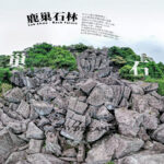
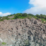
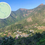
🐴 【Ma On Shan】 is located in the northeastern part of the New Territories, Hong Kong. Standing at 702 metres above sea level, it is the second-highest peak in the New Territories and is famous for its distinct “saddle” shape. Its main peak, Ma Tau Ting, is connected to the side peak, Ngau Ngap Shan, forming a curved ridge that resembles a horse saddle—which is how it got its name. The mountain is mainly made of volcanic tuff, and its steep eastern slope, known as “Kai Leng”, offers spectacular views overlooking Kei Ling Ha Hoi below. This area is not only a treasure trove for geologists but also a hugely popular hotspot for local hikers.
📌 Quick Facts
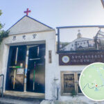
Item Details 📍 Location Spans across Sha Tin and Tai Po districts, separating Sha Tin from Sai Kung 🏔 Main Peak Ma Tau Ting, 702m above sea level; the highest main peak in eastern New Territories ⛰ Side Peak Ngau Ngap Shan, around 670m; connects with the main peak to form the iconic saddle shape 🪨 Eastern Slope A steep cliff known as “Kai Leng”, with Kei Ling Ha Village and Three Fathoms Cove at its foot 🧱 Geology Volcanic tuff and rhyolite dykes, formed around 100 million years ago 🌳 “Three Treasures” Iron ore, barking deer, and wild rhododendrons 🏛 Cultural Heritage St. Joseph’s Church, the mineral dressing plant, and the Ma On Shan Mining Heritage Centre 🌿 Ngong Ping Plateau Sitting at around 400m, it’s one of Hong Kong’s few alpine meadows, offering panoramic views over Sai Kung Sea; it is also a famous paragliding hotspot 🔺 Pyramid Hill Over 500m high, shaped like a pyramid with steep terrains; best for experienced hikers 🏞 Country Park Part of Ma On Shan Country Park, covering around 2,880 hectares of ridges, valleys, and old villages — Ma On Shan is famous not just for its stunning natural scenery, but also for its rich history and culture. Back in the day, the iron mine here attracted thousands of miners who formed a vibrant community, leaving behind precious heritage sites like St. Joseph’s Church. Today, Ma On Shan Country Park covers over 2,800 hectares, featuring the lush Ngong Ping Plateau, the rugged Pyramid Hill, and wild rhododendrons that burst into bloom every spring. It is both a thriving ecological hub and a repository of local memories, making Ma On Shan a true icon of Hong Kong’s hiking culture. —
🌿 Ecology & The “Three Treasures”
- Iron Ore: Ma On Shan was once a major iron mining hub in Hong Kong, with magnetite being the primary mineral extracted.
- Barking Deer (Northern Red Muntjac): A species of deer with reddish-brown coats. The males have small antlers; they are incredibly shy and mostly active at night.
- Rhododendrons: Blooming in spring, these wild flowers add vibrant splashes of colour to the hillsides of Ma On Shan.
—
🏛 History & Culture
- The Mining Era:
- Mining began way back in 1906 and was taken over by Japanese forces during the occupation.
- In 1949, Mutual Trust Co. partnered with a Japanese enterprise, leading to the growth of a full-fledged mining village community.
- During its peak, over 5,000 residents lived here, complete with quarters, schools, and churches.
- Operations finally wrapped up in 1976 due to dropping global steel demand.
- Cultural Heritage:
- St. Joseph’s Church and the ruins of the mineral dressing plant are listed as Grade 2 and Grade 3 historic buildings respectively.
- In 2012, the site was revitalised into the Ma On Shan Mining Heritage Centre, which now runs guided tours to keep the local mining history alive.
—
🚶 Hiking Trails
Difficulty Route Name Highlights Estimated Time 🟢 Beginner Ma On Shan Country Trail Around 4.5km on gentle paths, perfect for families and casual hikers; leads straight up to Ngong Ping Plateau for picnics and watching paragliders. Approx. 2–3 hours 🟡 Intermediate Pak Kong Bamboo Trail to Tai Shui Hang Walk along an old trail passing through traditional Hakka villages to soak up the local culture, complete with scenic valleys and shaded woodlands. Approx. 3–4 hours 🔴 Advanced Tiu Shau Ngam (Hang On Rock) Outer Ridge Route Requires hands-on scrambling across steep and rugged terrains, rewarding you with epic panoramic views over Sai Kung Sea and the Sha Tin cityscape. Approx. 4–5 hours 🔵 Long-distance MacLehose Trail Section 4 Cuts across Ngong Ping Plateau towards Sai Kung, packing ridges, grassy meadows, and stunning ocean vistas into one go; great for hikers with solid endurance. Approx. 6–7 hours