🌊 【Sea Caves】 are primarily clustered around bedrock islands along the coastal rims of Sai Kung and northeastern Hong Kong, representing magnificent landforms sculpted by long-term wave erosion[cite: 1]. Iconic caves include Jin Island Cave, Wang Chau Kok Cave, Sha Tong Hau Cave, Lam Wan Kok Cave, Crane Rock Cave, and Shui Lin Cave (Water Curtain Cave) / Flying Squirrel Rock[cite: 1]. Some of these are nestled within the boundaries of the Hong Kong UNESCO Global Geopark, balancing immense scientific research value with sightseeing appeal[cite: 1].—
🌊 Formation Mechanism of Sea Caves
Item Description 🪨 Geological Background Hong Kong is largely composed of volcanic rocks (covering approx. 50% of the landmass) and granites, with the outlying islands of Sai Kung being particularly renowned for the columnar jointing of rhyolitic tuffs[cite: 1] 🌊 Cause of Formation Waves continuously lash against weak lines (fractures) in the rocks, which, through wet-and-dry cycles, solution, and abrasion, gradually carve out horizontal or tunnel-like caverns[cite: 1] 🔄 Evolutionary Process Sea Cave → Sea Arch → Sea Stack → Sea Geo, displaying a complete chain of coastal landform evolution[cite: 1] ✨ Key Features Cave mouths are mostly situated at the base of sea cliffs with diverse profiles; some allow boats to pass through, while others are precipitously narrow, presenting immense sightseeing and scientific research values[cite: 1] —
🗺️ Geographical Regions & Touring Routes
- Sai Kung Volcanic Rock Region: Comprises the Ung Kong Group and Ninepin Group, showcasing the rare co-existence of hexagonal volcanic rock columns and sea caves[cite: 1].
- Northeast New Territories Sedimentary Rock Region: Includes Ping Chau and North Ninepin Island; apart from sea caves, it features peculiar rocks such as truncated cliffs and Kang Lau Shek (Watchtower Stones)[cite: 1].
- Touring Method: The premier way to view these landforms is by chartering a boat from Sai Kung or joining a Geopark guided tour to embark on a half-day “marine geological voyage” (海上地質之旅)[cite: 1].
—
✨ Characteristics & Value
- Geological Research Value: Demonstrates a rare natural marvel where coastal wave erosion co-exists alongside volcanic rock columns[cite: 1].
- Tourism & Sightseeing Value: Certain caves allow boats to enter or can be explored by wading, making them highly popular hotspots[cite: 1].
- Ecological Character: Features unique highlights such as the bat colonies in Crane Rock Cave and the dripping water vistas in Shui Lin Cave, blending natural ecology with geomorphological beauty[cite: 1].
—
📍 Major Distribution Locations & Key Features
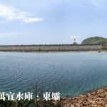
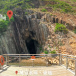
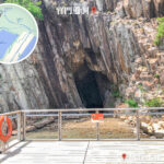
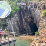
Cave Name Location Key Features Difficulty Rating Transportation Jin Island Cave (Tiu Chung Cave) Kau Sai Chau (Error in text context: Tiu Chung Cave is on Jin Island/Tiu Chung Chau) The cave is approx. 16 m deep and 3 m high, shaping like a giant bell; small boats can enter, and a pebble beach rests inside[cite: 1] ⭐ Easy[cite: 1] Approx. 30 minutes by boat from Sai Kung Pier[cite: 1] Wang Chau Kok Cave Ung Kong Group The cave stands over 20 m high and spans about 6 m wide; features torrential currents and precipitous, rugged scenery[cite: 1] ⭐⭐⭐ Challenging[cite: 1] Charter a boat from Sai Kung Pier; requires familiarity with the waters as it is highly affected by tides[cite: 1] Sha Tong Hau Cave Bluff Island (Chiu Pik Chau) Flanked by a sea cliff approx. 30 m high; the cave passage is as narrow as a lane, making boating through feel like navigating a car in a tight alley[cite: 1] ⭐⭐ Moderate[cite: 1] Take a boat from Sai Kung Pier; strict mastery of tidal timings is required[cite: 1] Lam Wan Kok Cave Basalt Island (Fo Shek Chau) The cave is approx. 16 m high; features rapid waves and surging tides with numerous fractures on the cave roof, making it treacherous and difficult to enter[cite: 1] ⭐⭐⭐ Challenging[cite: 1] Take a boat from Sai Kung Pier; suitable only for highly experienced boatmen[cite: 1] Crane Rock Cave Yong Shue Pai / Bluff Island (Ching Chau error in text) The cave mouth is as spacious as a grand hall but turns narrow and winding deeper inside; filled with pebbles and serves as a bat roost[cite: 1] ⭐⭐ Moderate[cite: 1] Take a boat from Sai Kung Pier; easier to enter during low tide[cite: 1] Shui Lin Cave (Water Curtain Cave) Near Basalt Island Water drips from the cave ceiling like a curtain; visitors can land and explore during low tide, offering rich ecological features[cite: 1] ⭐ Easy[cite: 1] Take a boat from Sai Kung Pier; landing is possible during low tide[cite: 1] Mok Min Cave Near MacLehose Trail Section 1 Accessible on foot; visitors can venture inside for an adventure during low tide, boasting a magnificent cave mouth[cite: 1] ⭐⭐ Moderate[cite: 1] Hike along Section 1 of the MacLehose Trail and walk along the shoreline[cite: 1] High Island Cave (Leung Shuen Wan Cave) East Dam, High Island Reservoir A sea cave carved into volcanic tuff, displaying spectacular volcanic rock scenery[cite: 1] ⭐ Easy[cite: 1] Take a vehicle from Sai Kung to East Dam, followed by a short walk to the cave mouth[cite: 1] —
—
🔑 Guiding Tips
- Best Season: Autumn and winter, when sea waves are relatively calm and stable, offering clear visibility[cite: 1].
- Safety Alert: Certain caves are heavily influenced by tides; close attention must be paid to high and low tide schedules[cite: 1].
- Sightseeing Method: Chartering a boat from Sai Kung Pier is the most common approach, which can also be combined with hiking itineraries[cite: 1].
- Scientific Value: The caves showcase a rare geological phenomenon where volcanic rock columns and marine erosion co-exist in unison[cite: 1].