🏞️ 【Tai Shui Hang (大水坑)】 is primarily located in the Sha Tin District of the New Territories, forming the southern section of the Ma On Shan New Town, specifically just north of A Kung Kok. The name comes from its natural geography, where two mountain streams—Ma Dai Stream (originating from Ma On Shan) and Mui Dai Stream (originating from Shek Lung Tsai and Mau Ping)—merge here before emptying into Sha Tin Hoi. Historically, Mui Dai Stream served as the District Council electoral boundary separating Sha Tin New Town from Ma On Shan New Town. —
📌 Quick Facts
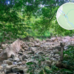
Item Details 🏞️ Location Name Tai Shui Hang 🗺️ District Sha Tin District, New Territories, Hong Kong; part of Ma On Shan New Town. 📍 Geography Situated in southern Ma On Shan, north of A Kung Kok, near the Shing Mun River and Sha Tin Hoi. 🌊 River System Ma Dai Stream and Mui Dai Stream converge here to form the Tai Shui Hang watercourse, which flows into Sha Tin Hoi. 🧭 Name Origin Named “Tai Shui Hang” (literally “Big Water Trench”) because the fast-flowing mountain streams gathered into a deep channel here. 🚉 MTR Station Tai Shui Hang Station (Tuen Ma Line), connecting to Ma On Shan, Sha Tin, Tai Wai, and beyond. 🚌 Transport Hubs Chevalier Garden Bus Terminus and Tai Shui Hang Village Car Park, served by various bus and minibus routes. 🚖 Taxi Boundary New Territories (green) taxis cannot operate on A Kung Kok Street west of Hang Shin Street, marking the operational boundary for NT taxis. 🏘️ Main Residential Areas Chevalier Garden, Kam Tai Court, Mountain Shore, Ocean View, Ocean Crest, Sausalito, Oceanaire, and more. 🏫 Schools Kowloon City Baptist Church Hay Nien Primary School, Ma On Shan Tsung Tsin Secondary School, and other nearby institutions. 🛍️ Shopping & Amenities We Go Mall, convenience stores, restaurants, clinics, and fully equipped community facilities. 🚴♂️ Recreation Tai Shui Hang Cycling Park, Ma On Shan Promenade, and Shing Mun River riverside paths. 🏡 Village History Tai Shui Hang Village is an indigenous New Territories village established by the Cheung clan about 300 years ago. 🗳️ Electoral Constituency Formerly part of the “Tai Shui Hang Constituency,” later rezoned into “On Tai Constituency,” “Oi Lam Constituency,” etc. 🏞️ Natural Environment Surrounded by mountains and streams, retaining some original landforms ideal for hiking and nature observation. — It is worth noting that there is more than one stream named “Tai Shui Hang” in Hong Kong. For instance, in eastern Lantau Island, between Discovery Bay and Mui Wo, lies another “Tai Shui Hang.” Its downstream area is home to Our Lady of Joy Abbey (Trappist Haven Monastery, which moved to its current site in 1956), the monastery that founded the famous “Kowloon Dairy” brand. That stream draws hikers and stream-trekking enthusiasts due to its cascading waterfalls and scenic terrain. Meanwhile, the Ma Dai Stream near Sha Tin’s Tai Shui Hang is well-known for natural attractions like “Hero Waterfall” and “Hero Pool,” making it a popular choice for summer stream trekking, though visitors must prioritize safety and hike with experienced guides. —
🗺 Geography & Name Origin
- Location: Tai Shui Hang is situated in the northeastern part of Sha Tin District in the New Territories. It forms the southern part of Ma On Shan New Town, located between Ma On Shan proper and A Kung Kok.
- Name Origin: The area originally featured two mountain streams—Ma Dai Stream to the north and Mui Dai Stream to the south. The fast-flowing waters converged and emptied into Sha Tin Hoi, giving rise to the name “Tai Shui Hang.”
- Stream Course:
- Ma Dai Stream originates from Ma On Shan and flows down through Ma On Shan Village.
- Mui Dai Stream originates from Shek Lung Tsai and Mau Ping, flowing down through Mui Zei Lam.
- The two streams merge right in front of Tai Shui Hang Village and flow through culverts into Sha Tin Hoi.
—
🏘 History & Village Culture
- Village Origins: Around 300 years ago, ancestors of the Cheung clan migrated here from Wuhua County in Guangdong Province to settle. The family line has now spanned thirteen generations.
- Traditional Lifestyle:
- Villagers traditionally relied on farming, livestock rearing, and seafaring for their livelihood.
- Facing Ma Liu Shui across the water, the village enjoyed convenient maritime transport, and residents used wooden boats to travel back and forth to market towns.
- Present Day: While the original natural streams have dried up, the village still retains its traditional character.
—
🚉 Transport Network & Infrastructure
- MTR Station: Tai Shui Hang Station is part of the Ma On Shan Line (Tuen Ma Line), bridging Sha Tin town center and Ma On Shan New Town.
- Key Roads:
- Ma On Shan Road (connecting to the Tate’s Cairn Highway)
- Hang Shin Street and Hang Tak Street (providing access to Chevalier Garden and the local village)
- Bus Terminus: Chevalier Garden Bus Terminus serves as a vital neighborhood hub, offering multiple bus and minibus routes for residents’ daily commutes.
— The development of the 【Tai Shui Hang】 area is a textbook example of integrating new town urban planning with natural landforms. The region boasts public housing estates (such as Yan On Estate), private residential complexes (such as Ocean View, Sausalito), Home Ownership Scheme (HOS) developments, and Sandwich Class Housing (such as Chevalier Garden, Kam Tai Court), alongside traditional indigenous settlements like Tai Shui Hang Village. On the transport front, Tai Shui Hang MTR Station opened in 2004, primarily serving the surrounding residents, schools, and students. The station was named for its regional identity rather than after any single housing development. —
🏡 Community Development & Residential Projects
- Chevalier Garden:
- A Home Ownership Scheme (HOS) development built under the Private Sector Participation Scheme.
- Phase 1 was completed in 1986, followed by Phase 2 in 1987.
- Other Residential Estates:
- Kam Tai Court
- Mountain Shore Clarification
- Ocean View
- Ocean Crest
- Oceanaire
- Educational Institutions:
- Kowloon City Baptist Church Hay Nien Primary School
- Ma On Shan Tsung Tsin Secondary School
—
🌳 Natural Environment & Open Spaces
- Tai Shui Hang Cycling Park: Offers cycling tracks and recreational amenities, serving as a popular weekend spot for both locals and visitors.
- Ma On Shan Promenade: A highly popular seaside walkway running along the coast, offering beautiful waterfront views.
—
🧭 Administrative Divisions & Constituency Evolution
- Constituency Boundaries:
- Mui Dai Stream historically marked the dividing line between Sha Tin and Ma On Shan New Town.
- Prior to the 2023 constituency restructuring, Tai Shui Hang was divided under the “Tai Shui Hang Constituency” and “On Tai Constituency.”
- Taxi Operating Limits:
- Tai Shui Hang is one of the boundary limits for New Territories green taxis.
- NT taxis are prohibited from picking up or dropping off on A Kung Kok Street west of Hang Shin Street.
—
🧪 Water Quality Monitoring & Environmental Measures
- EPD Monitoring:
- The Environmental Protection Department operates four water quality monitoring stations (TSH1–TSH4) in Tai Shui Hang.
- Samples are taken twice a month during the wet season and once a month during the dry season to grade the health of the stream.
—