🗼 【Mount Johnston Lighthouse (玉桂山 燈塔)】(also known as Ap Lei Pai Lighthouse) is located at the southern tip of Ap Lei Pai in the Southern District of Hong Kong. Built in 1912, it is a white navigation lighthouse standing about 5.5 meters tall with the designation No. 198. Its primary purpose is to provide guidance for vessels navigating the East Lamma Channel and the Aberdeen Channel. This well-preserved lighthouse features a classic British colonial architectural style and is surrounded by spectacular coastal erosion landforms and reef clusters. It offers sweeping views of Lamma Island, Ngan Chau, and Ocean Park. Its unforgettable sunset scenery has made it a highly popular hotspot for photography enthusiasts. —
📌 Basic Information
Item Details 🗼 Name Mount Johnston Lighthouse (also known as Ap Lei Pai Lighthouse) 📍 Location Ap Lei Pai, at the southern end of Mount Johnston (Yuk Kwai Shan) on Ap Lei Chau, Hong Kong. It sits close to the East Lamma Channel at an elevation of about 68 meters 🌐 Geographical Coordinates Approx. 22.228°N, 114.162°E (near Ap Lei Pai) 🧭 Function Provides navigational guidance for vessels to ensure maritime safety in the East Lamma Channel and Aberdeen Channel 🧱 Architectural Features A well-preserved white cylindrical lighthouse built on rock, showcasing a colonial-era architectural style 🌅 Scenic Highlights 360-degree panoramic ocean views overlooking Lamma Island, Ngan Chau, Ocean Park, and Brick Hill (Nam Long Shan) 🚶♂️ Hiking Route Lei Tung Estate → Mount Johnston → Ap Lei Pai Tombolo → Ap Lei Pai → Lighthouse. Total distance is approx. 4.5 km, taking around 2.5–4 hours 🧗♂️ Trail Difficulty Intermediate. Some sections require scrambling; the gravel slopes are steep. Bringing gloves and wearing non-slip shoes is highly recommended ⚠️ Important Notes No supply points or shade along the way—take precautions against heatstroke in summer. The helper ropes have worn out, so do not rely on them. High presence of litter; please bring your own trash bags — The unique charm of the Mount Johnston Lighthouse lies in its geographical setting—it must be reached by crossing the Ap Lei Pai Tombolo. This sandspit, stretching about 200 meters long, is fully exposed at low tide but completely submerged at high tide, creating a true “limited-time hidden wonderland.” The volcanic tuff on both sides of the tombolo has been eroded by waves to form honeycomb rocks and sea caves, which are designated under the “Hong Kong Island Volcanic Rock Region” of the Hong Kong UNESCO Global Geopark. The area surrounding the lighthouse also retains the remnants of a World War II British military battery (Aberdeen Battery). This battery was deliberately destroyed by British forces in 1941 during the Battle of Hong Kong to prevent it from falling into Japanese hands, adding significant historical exploration value to the trip. — — Reaching the lighthouse requires hikers to first scale the 196-meter-high Mount Johnston, before descending a steep, loose gravel path down to the tombolo. The entire round trip spans about 4 kilometers and takes 3 to 4 hours to complete. It carries a difficulty rating of 3 to 4 stars (out of 5), making it best suited for experienced hikers. Because the trail conditions are treacherous and completely exposed to the sun, it is recommended to bring gloves, hiking poles, and plenty of drinking water. Hikers must carefully check the tide timetables beforehand (crossing is recommended only when the tide level is below 1.3 meters) to avoid getting stranded. This route blends natural wonders, military ruins, and maritime history into one of Hong Kong’s rarest mountain-and-sea adventure experiences. —
📍 Locations & Background
Name Description Mount Johnston (Yuk Kwai Shan) Located at the southern end of Ap Lei Chau, it was named after the former Deputy Governor of Hong Kong, Alexander Robert Johnston. Standing at an elevation of 196 meters, it is one of the highest vantage points in the Southern District, offering 360-degree ocean views that look out toward Lamma Island and Ocean Park Ap Lei Pai An uninhabited islet connected to Mount Johnston by a natural tombolo, serving as the most iconic and unique stretch of the entire hiking route Ap Lei Pai Tombolo A sand-and-gravel pathway exposed during low tide that acts as a natural bridge connecting Mount Johnston and Ap Lei Pai Mount Johnston Lighthouse (also known as Ap Lei Pai Lighthouse) Situated at the southern tip of Ap Lei Pai facing the East Lamma Channel, this maritime navigation facility is a popular photography location for sunset silhouettes, crashing waves, and lighthouse portraits —
🏗️ Lighthouse History & Architectural Features
- Built in the 1960s and managed by the Hong Kong Marine Department
- Guides vessels safely through the East Lamma Channel and Aberdeen Channel
- Features a white structure standing about 6–8 meters tall, set on a concrete platform
- Not open to the public; views and photography are restricted to its exterior
—
🥾 Hiking Route
Starting Point Passing Through Destination Total Distance Estimated Time Difficulty MTR Lei Tung Station, Exit B Lei Tung Estate ➝ Mount Johnston ➝ Ap Lei Pai Tombolo ➝ Ap Lei Pai ➝ Lighthouse ➝ Return via the same route Ap Lei Pai Lighthouse Approx. 4 km Approx. 3.5–4 hours Intermediate-Hard 🧭 Mount Johnston Climbing Section:
- Starts at the staircase next to the Lei Tung Estate bus terminus, offering three route options: left, middle, and right
- The summit features a trigonometrical station at an elevation of 196 meters
- Overlooks the Aberdeen Typhoon Shelter, Lamma Island, and Brick Hill
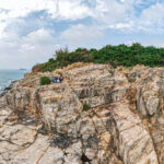
🧭 Ap Lei Pai & Lighthouse Section:
- After crossing the tombolo, scale Ap Lei Pai, which reaches a peak elevation of about 68 meters
- Follow the narrow trail toward the lighthouse, offering views of Ngan Chau and the eastern coast of Lamma Island along the way
—
⚠️ Safety & Gear Reminders
Safety Suggestions:
- Never attempt to cross the tombolo during high tide (crossing is recommended when the tide level is below 1.5 meters)
- Do not hike alone; a group of at least three people is recommended
- Inform family or friends of your itinerary and bring a GPS tracking tool
- Rocks around the lighthouse are slippery; do not stand too close to the breaking waves for photos
- If planning to catch the sunset, bring a headlamp for a safe return journey
- Summer sun exposure is intense; it is advisable to avoid hiking during midday hours
Recommended Gear:
- Wear non-slip hiking shoes and bring gloves for sections requiring rope assists
- Gloves
- Headlamp
- Sun hat and sunglasses
- Drinking water (at least 1.5 liters) and dry snacks, as there are no supply points along the way
—
🔍 Extended Information:
- Mount Johnston stands at approximately 196 meters and was named after Alexander Robert Johnston, the former Deputy Governor of Hong Kong.
- The highest point of Ap Lei Pai is about 68 meters, making it a premier location for coastal photography and ocean vistas.
- The tombolo connecting Mount Johnston and Ap Lei Pai offers magnificent scenery but features rugged trail conditions.
—