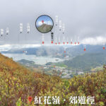
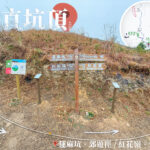
🏔️【Chek Hang Teng (直坑頂)】 is located in Sha Tau Kok, North District, New Territories, Hong Kong. Sitting right next to the Shenzhen border, it is part of the Robin’s Nest mountain range and one of the peaks within Robin’s Nest Country Park. Although it isn’t the highest peak, its rugged terrain and central location make it a key node along the northern ridge of Robin’s Nest. While Chek Hang Teng might not be the tallest summit, it holds significant geographical, ecological, and historical value, forming a cross-border ecological corridor with Sha Tau Kok and Wutong Mountain in Shenzhen.
📌 Basic Information
Item Details ⛰️ Elevation Around 440–460m; one of the foothills of Robin’s Nest with a relatively gentle slope 📍 Location Situated in the northeastern part of Robin’s Nest, close to Sha Tau Kok and connected to Wutong Mountain in Shenzhen 🪨 Geology Granite geology featuring gentle slopes and crisscrossing mountain streams, creating diverse habitats 🌳 Designated Area Robin’s Nest Country Park 🏞️ Nearby Peaks Robin’s Nest Main Peak (492m), Hung Fa Chai (489m), Shek Tsui Shan 🗺️ Landscape Features The ridgeline extends to Lin Ma Hang, dotted with old mine relics and WWII defensive fortifications along the way —
🌿 Ecology & Environment
Item Details 🐾 Biodiversity As the Robin’s Nest area was a closed border zone for a long time, human disturbance has been minimal, preserving over 650 species of flora and fauna 🦋 Notable Species Home to various butterflies, dragonflies, mammals, and the globally rare Large Grass Warbler (Graminicola striatus)—with Hong Kong hosting 90% of its global population 🦇 Bat Colony The Lin Ma Hang Lead Mine is one of the most vital bat habitats in Hong Kong 🌐 Ecological Corridor Chek Hang Teng and the Robin’s Nest main peak link up with Wutong Mountain in Shenzhen, forming a cross-border ecological corridor crucial for conservation 🌸 Vegetation Dominated by grasslands and shrublands, with wild Rhododendrons bursting into bloom during spring —
🏯 History & Heritage
Item Details 🚧 Frontier Closed Area Background The area around Chek Hang Teng used to be part of the Frontier Closed Area, which helped preserve many wartime relics 🛡️ Military Relics Features a MacIntosh Fort built between 1949 and 1953 for border defense, now classified as a Grade 2 Historic Building 🏡 Village Culture Located near Lin Ma Hang Village, a 300-year-old settlement where villagers historically relied on farming ⛏️ Mining Heritage The Lin Ma Hang Mine was once the largest mining operation in Hong Kong; it was later abandoned and has since become a major bat sanctuary —
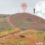
🚶♂️ Hiking & Sightseeing
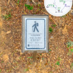
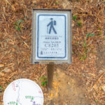
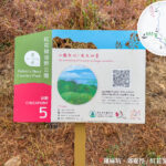
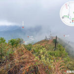
- Hiking Trails: Robin’s Nest Country Park features the Robin’s Nest Country Trail and the Lin Ma Hang Country Trail, both of which pass through the Chek Hang Teng area.
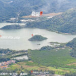
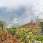
- Scenic Views:
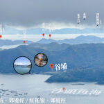
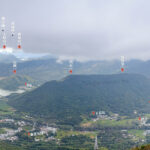
- Looking north: Shenzhen cityscape
- Looking south: Pat Sin Leng
- Looking east: Sha Tau Kok Sea (Starling Inlet)
- Difficulty: Moderate; suitable for hikers with a bit of experience.
—
✨ Significance
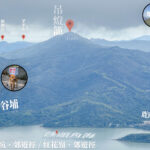
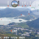
- Geographical: Chek Hang Teng serves as a “midway junction” on the northern ridge of Robin’s Nest, connecting several peaks.
- Ecological: A vital link in the cross-border ecological corridor.
- Cultural: Stands as a witness to Hong Kong’s border history and traditional village life.
—
📍 Key Landmarks
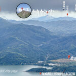
- Robin’s Nest Main Peak: The highest peak in North District, standing at 492m.
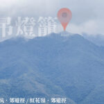
- Chek Hang Teng: A branch ridge of Robin’s Nest with a relatively gentle terrain.
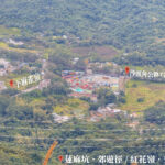
- Lin Ma Hang Village: A historic Hakka village with deep roots.
- Lin Ma Hang • Mine: Hong Kong’s largest abandoned mine, currently a protected bat habitat.
- MacIntosh Forts: Grade 2 Historic Buildings that bear witness to border defense history.
—
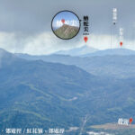
🌸 Robin’s Nest Northern Ridge Hiking Route
Section Key Landmarks Elevation Highlights Starting Point Wo Hang Au Approx. 150m Trail trailhead, a popular starting point for hikers Section 1 Shek Tsui Shan Approx. 350m Open, sweeping hillsides with clear views overlooking Starling Inlet (Sha Tau Kok Sea) Section 2 Chek Hang Teng Approx. 440–460m Midway junction of the northern ridge offering wide views; connects to Robin’s Nest Main Peak Section 3 Hung Fa Chai Approx. 489m Steep and rugged ridgeline, situated right next to the main peak Main Peak Robin’s Nest Approx. 492m The highest summit in North District, offering distant views of the Shenzhen cityscape Descent Lin Ma Hang Village Approx. 100m An ancient village located close to the old mine caves and historical relics —
🚶♂️ Difficulty & Duration
- Difficulty: Moderate to Difficult (ridgeline sections can be quite steep)
- Total Time: Around 4–5 hours
- Best Season: Autumn and Winter (cool, dry, and offers the best visibility)
—
🌟 Trail Highlights
- 🏯 Historical Relics: Lin Ma Hang • Mine, MacIntosh Forts
- 🌸 Natural Scenery: Wild rhododendrons blooming in spring, cross-border ecological corridor
- 🌆 Panoramic Views: Starling Inlet, Shenzhen cityscape, and the mountain ranges of North New Territories