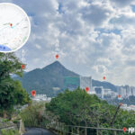
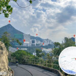
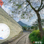
🚶【Mount Davis Path (摩星嶺徑)】 is a hiking route located at the western end of Hong Kong Island, spanning approximately 4–6 km with a peak elevation of about 260 metres. Along the way, you can overlook the magnificent Sulphur Channel, gaze out at Green Island and Little Green Island, and take in the vast South China Sea. It is not only an excellent spot for watching the sunset 🌅, but also a popular choice for photography enthusiasts due to its open terrain. While walking along the path, visitors can experience the unique geographical features of the west coast of Hong Kong Island, where the sea and sky blend together in contrast to the tranquility found at the edge of the city.
📌 Quick Facts
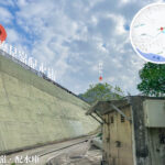
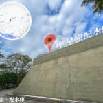
Item Details 📍 Location Western Hong Kong Island, south of Kennedy Town ⛰️ Elevation Mount Davis Peak, approx. 260 metres 🚶 Route Length Approx. 4–6 km (depending on whether you choose Mount Davis Path or the “Friends of Mount Davis Trail”) ⏱️ Time Required Approx. 1.5–2.5 hours 💪 Difficulty ⭐⭐⭐ (Easy to moderate, though some branch paths can be rugged) 🚇 Transport MTR Kennedy Town Station, Exit A is the most convenient starting point. Follow Smithfield or Victoria Road to reach the trailhead. — Beyond its natural beauty, Mount Davis Path also carries a deep historical legacy 🏰. The ruins of the Mount Davis Battery and Jubilee Battery from WWII still stand along the trail, bearing witness to the history of Hong Kong’s defense during wartime. Today, these military relics, together with the nearby Mount Davis Youth Hostel, have become the focus of cultural exploration. As such, Mount Davis Path is a route that blends natural scenery, military history, and cultural education, making it perfect for travelers who enjoy hiking, photography, and history. —
🌄 Geographical and Natural Features
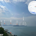
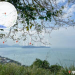
Category Details 🗺️ Western Landmark Mount Davis is the westernmost hill on Hong Kong Island, facing Green Island and separated by the Sulphur Channel 👀 Views From the summit, you can look out at Lamma Island, Cheung Chau, Lantau Island, and the Tsing Ma Bridge 🌳 Ecology Dense vegetation along the way, commonly featuring Banyan Trees and Acacia; you may occasionally encounter wild boars or monkeys 🌅 Sunset Hotspot A famous sunset viewing point in Western District, especially at the Sunset Pavilion —
🏛️ History and Culture
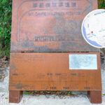
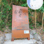
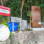
- Mount Davis Fort: Built in 1912, it included batteries, command posts, observation towers, and barracks.
- Jubilee Battery: Built in 1939, it was equipped with three cannons to defend Victoria Harbour.
- WWII Role: Served as a key firing point during the Battle of Hong Kong in 1941 before being bombed by the Japanese military.
- Post-War Use: Once used to house Nationalist soldiers; formerly the site of a “White House” detention centre, which has since been demolished.
- Modern Facilities: The summit area houses the Mount Davis Youth Hostel and retains some military relics, which are classified as Grade II historic buildings.
—
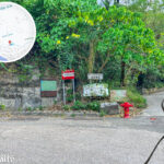
🗺️ Route Options
- Mount Davis Path: A paved road with good conditions, suitable for beginners.
- Friends of Mount Davis Trail: A smaller trail developed by local residents; it is more primitive with many branch paths and higher difficulty, but it allows you to avoid retracing your steps.
—
🌄 Geographical Features
Location Features Photography Tips ⛰️ Mount Davis The westernmost peak on Hong Kong Island with wide-open views of Lamma Island, Cheung Chau, Lantau Island, and the Tsing Ma Bridge Best visited on clear days; use a wide-angle lens for panoramic shots 🌊 Sulphur Channel Separates Mount Davis from Green Island with distinct layers of sea scenery Use a telephoto lens to photograph passing ships for a sense of motion 🌇 Sunset Pavilion One of the best locations for sunset photography Best time: 30 minutes before sunset to capture the afterglow and silhouettes —
🏰 History and Culture
- Mount Davis Battery: Built in 1912 with five batteries, command posts, observation towers, and barracks; became an important defense line during WWII.
- Jubilee Battery: Built in 1939 with three cannons to defend Victoria Harbour.
- WWII History: The Mount Davis Fort fought fiercely during the Japanese invasion in 1941 before being destroyed; the ruins are now a Grade II historic site.
- Mount Davis Youth Hostel: Managed by the HKFYG, it is located near the summit and offers accommodation and educational activities.
—
🌿 Ecology
- Plants: Local species such as Banyan Trees and Acacia can be seen along the route.
- Animals: Occasionally, you may spot wild boars or monkeys.
🗓️ Mount Davis Path Day Trip Itinerary
Time Activity Location (English) Highlights 09:00 Gather and Depart Kennedy Town MTR Station Convenient transport, urban starting point 09:30 Start Hiking Victoria Road Trailhead Paved road with moderate incline 10:00 On the Trail Mount Davis Path Overlook Sulphur Channel, Green Island & Little Green Island 11:00 Explore Military Relics Mount Davis Battery WWII relics, bunkers, batteries, command posts 12:30 Picnic Lunch Battery Platform View Lamma Island and Lantau Island 13:30 Cultural Exploration Mount Davis Youth Hostel Jockey Club-funded, education and accommodation facilities 14:30 Ecological Branch Trail Friends of Mount Davis Trail Primitive path, diverse plants, chance to encounter wild boars 17:00 Sunset Photography Sunset Pavilion Best sunset shooting spot, views of Tsing Ma Bridge 18:30 Return Kennedy Town End of trip, dinner in the city —
✨ Tips
- Best Time: Evening hours, perfect for sunset and night view photography.
- Gear: Hiking shoes, sun protection, and sufficient drinking water.
- Nearby Attractions: You can also visit the Sai Wan Swimming Shed and the Boundary Stone of Victoria City, both of which are popular social media check-in spots.