🛣️【Ngong Ping Road (昂坪路)】 is the main thoroughfare in the Lantau Island Ngong Ping region, Hong Kong. Starting from near Sham Wat Road in the west and stretching to the Lin Ping Road roundabout right outside Ngong Ping Plaza in the east, it spans a total length of about 2.6 km. Connecting multiple major hotspots, this road is the definitive gateway to Po Lin Monastery, the Tian Tan Buddha, the Wisdom Path, and the Ngong Ping 360 Cable Car Terminal. Historically a narrow and rugged village track, Ngong Ping Road underwent large-scale improvement works in the 1990s. Today, it has been widened into a standard 7.3m-wide dual-lane carriageway equipped with pavements, significantly boosting its traffic capacity and safety. —
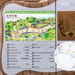
📌 Key Information
Item Details 🛣️ Road Name Ngong Ping Road 📍 Location Ngong Ping, Lantau Island, Islands District, New Territories, Hong Kong 🔜 Starting Point Sham Wat Road (near the Water Supplies Department pumping station and break pressure tank) 🏁 Ending Point Lin Ping Road Roundabout (near Ngong Ping Plaza) 📏 Total Distance Approx. 2.6 km ⛰️ Altitude Change 320m → 440m, making it one of the roads with the highest average altitude in Hong Kong 🚗 Speed Limit Approx. 50 km/h 🧭 Terrain Profile Mountainous road with steep gradients and sharp bends; it was narrow and difficult to navigate in the early days 🔀 Major Junctions West End: Sham Wat Road (heading towards Shek Pik and Tai O)
East End: Lin Ping Road (access to Ngong Ping Village, Po Lin Monastery, and Tian Tan Buddha)🛤️ Road Layout Undivided dual-lane single carriageway, though certain spots remain single-lane two-way traffic 🏗️ Upgrade Timeline Improvements began in 1972, with widening works completed in 1993 to bring it up to standard dual-lane specifications 🚫 Access Restrictions History Lantau taxis and double-decker buses were previously banned, but restrictions have since been phased out 🚌 Transport Infrastructure Ngong Ping Public Transport Interchange (opened in 2006, featuring dedicated bays for buses, taxis, and coaches) 🛣️ Intersecting Roads Sham Wat Road, Po Ngong Road, Lin Ping Road — Today, Ngong Ping Road is far more than just a vital traffic artery; its surroundings are packed with a rich tapestry of cultural and natural landscapes. Iconic landmarks like Po Lin Monastery, the Tian Tan Buddha, and the Wisdom Path are dotted along the route, drawing crowds of tourists. In terms of public transport, the road is serviced by franchised bus routes like New Lantau Bus Route 23. The transformation of Ngong Ping Road from a basic rural track into a seamless tourist corridor mirrors the evolution of Ngong Ping into a major religious, cultural, and tourism hub in Hong Kong. —
🛣️ Sections and Scenic Highlights
- Ngong Ping Entrance Section: Entering the heart of the plateau, this section is flanked by landmarks like Ngong Ping Village, Po Lin Monastery, and the Tian Tan Buddha. It is a high-traffic zone where shops, eateries, and public toilets are concentrated.
- Mid-Section Hillside Bends: Characterised by a series of S-curves and guardrails. On a clear day, you can catch sweeping views of Lantau Peak, the Ngong Ping cable car towers, Shek Pik Reservoir, and the airport.
- West End Junction: Connecting to Sham Wat Road and Lantau South Country Park, this serves as a prime access point for major hiking trails like the Lantau Trail and the Fat Mun Ancient Trail.
—
🧭 Roadside Attractions and Cultural Landmarks
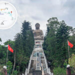
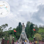
🌄 Tian Tan Buddha
- Standing 34m tall and weighing 250 tonnes, it is one of the largest outdoor bronze seated Buddhas in the world.
- Constructed in 1989 and officially consecrated in 1993.
- Visitors must climb 256 stone steps to reach the platform.
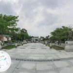
🏯 Po Lin Monastery
- Established in 1906, founded by three Zen masters from Jiangsu.
- The architecture beautifully blends Song, Ming, and Qing styles, featuring the Main Shrine Hall of Buddha and the Grand Hall of Ten Thousand Buddhas.
- The monastery’s dining hall serves authentic Buddhist vegetarian cuisine, making it an excellent spot for quiet reflection and a meal.
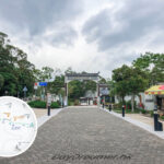
🛍️ Ngong Ping Village
- Designed in a traditional Chinese architectural style, hosting over 20 shops and restaurants.
- Popular photo spots include the “Blessing Drums” and the “Bodhi Wishing Tree”.
- Themed attractions like the “Motion 360” theater and “Walking with Buddha” offer immersive interactive experiences.
🌿 Wisdom Path
- An outdoor installation of 38 wooden pillars, each engraved with verses from the Heart Sutra.
- Set amidst a tranquil natural woodland, symbolising the fusion of Buddhist teachings and nature.
🚡 Ngong Ping 360 Cable Car
- Connecting Tung Chung and Ngong Ping over a 5.7 km span, offering breathtaking aerial views.
- Stands as one of the most popular ways to travel up to Ngong Ping.
—
🥾 Hiking Trails and Footpath Connections
- Lantau Trail • Section 4: Partially overlaps with Ngong Ping Road, making it a handy link for heading towards Lantau Peak or Shek Pik.
- Nei Lak Shan Country Trail: A 3.9 km loop that takes about 2 hours to complete, offering great views of Sunset Peak and sunset vistas over the airport.
- Ngong Ping 360 Rescue Trail: A mix of wooden boardwalks and steps; boasts wide-open views but is highly exposed to the sun.
—
🚍 Transport
Mode Details 🚌 Franchised Bus Route 23 (Tung Chung ⇄ Ngong Ping, approx. 50 minutes), Route 2 (Mui Wo ⇄ Ngong Ping), Route 21 (Tai O ⇄ Ngong Ping) 🚡 Ngong Ping 360 Cable Car Ngong Ping 360 (Tung Chung ⇄ Ngong Ping), a 5.7 km journey taking roughly 25 minutes 🚖 Taxi Restricted to blue 🚙 Lantau taxis only 🚗 Driving Classified as a Closed Road 🚧; a valid Lantau Driving Permit 📄 is strictly required 🚴♂️ Cycling Steep inclines and sharp curves ⚠️; only recommended for seasoned cyclists —
🏗️ Historical Milestones and Upgrades
1970s: Early Improvements
- Ngong Ping Road was originally a rugged village track—extremely steep, winding, narrow, and tough to drive on.
- In its early days, it could only accommodate small vehicles; double-decker buses could not safely pass through.
- In 1972, the government kicked off temporary improvements:
- Shaving down hazardous sharp corners
- Adding passing bays
- Setting up warning signs and guardrails
1990s: Comprehensive Reconstructed Widening
- With the impending completion of the Tian Tan Buddha and an anticipated surge in visitors, the government gazetted the road widening plan in 1990.
- A HK$66 million contract was awarded in 1991 to widen the road into a standard dual-lane carriageway (7.3m wide) complete with a proper pavement.
- The works wrapped up in 1993, dramatically increasing safety; Lantau taxis were subsequently granted access to Ngong Ping Road.
— The story of Ngong Ping Road is deeply intertwined with the development of surrounding tourist infrastructure. To cope with the massive influx of visitors expected after the opening of the Tian Tan Buddha, the Highways Department completely overhauled the road in the early 1990s. Following the launch of the Ngong Ping 360 Cable Car system in 2006, the authorities went a step further by constructing the Ngong Ping Public Transport Interchange at the junction of Ngong Ping Road and Po Ngong Road. This hub provides plenty of parking and boarding bays for buses, taxis, and tour coaches to meet the massive transport demand. In 2008, as part of the “Lantau Ngong Ping Public Facilities Improvement Project,” the old bus terminus was demolished and transformed into the 1.5-hectare Ngong Ping Plaza, significantly improving the connectivity between all the key attractions. —
🚍 Ngong Ping Public Transport Interchange (Opened in 2006)
Facility Type Capacity and Details 🚌 Bus Bays 5 bays 🚏 Bus Stacking Spaces 15 spaces 🚌 Coach Parking Spaces 17 spaces 🚖 Taxi Bays 7 bays ➕ 2 pick-up/drop-off spaces 🚗 Private Car Parking Spaces 22 spaces 🏍️ Motorcycle Parking Spaces 5 spaces 📍 Location Junction of Ngong Ping Road and Po Ngong Road, right next to Ngong Ping Village 🛍️ and the Cable Car Station 🚡 —
🥾 Hiking Trail: Nei Lak Shan Country Trail
Item Details 📍 Starting Point Near Ngong Ping Village 📏 Distance Approx. 3.9 km ⏱️ Time Required Approx. 2 hours, beginner-friendly 🌄 Views Offers stunning vistas of the airport, Sunset Peak, and the Tian Tan Buddha, with beautiful silvergrass blankets during autumn 🛠️ Amenities The Ngong Ping Nature Centre provides maps, hiking pole rentals, and guided tour services —
🍽️ Refreshments and Dining Tips
- Ngong Ping Village is packed with tea houses, cafes, and a good mix of Chinese and Western restaurants.
- After your day out, you can head down to Citygate Outlets in Tung Chung for dinner, where the dining options are incredibly diverse.
—
🌿 Natural Environment and Seasonal Outlook
- Late Spring / Early Summer: Prone to heavy fog and low visibility.
- Summer: Intense sunlight; sun protection and staying well-hydrated are absolute musts.
- Winter: Crisp, clear air, which makes it the absolute best season for sightseeing and views.
- Feral Cattle: Wild cows are a common sight along the roadside; please slow down and give them the right of way.
—
🌟 Fun Facts & Trivia
- Ngong Ping Road is one of the only land routes leading to the Tian Tan Buddha and Po Lin Monastery, making it a critical transport hub during peak holiday seasons.
- The government permanently closed the old Ngong Ping Bus Terminus in 2008, converting it into a landscaped plaza to drastically elevate the tourist experience.
- The Ngong Ping Sewage Treatment Works is the very first tertiary sewage treatment plant in Hong Kong to feature reclaimed water facilities—both eco-friendly and highly practical.
—