🗺️ 【Pak Kung Au】 (伯公坳 – also known as Tung Chung Au / 東涌坳) is a major mountain pass situated in central Lantau Island, Hong Kong. Standing at an elevation of approximately 340.8 metres, it is nestled in the saddle between Lantau Peak (934m) and Sunset Peak (869m), marking the highest point of Tung Chung Road. This location serves as a strategic transport corridor connecting the northern and southern parts of Lantau Island, as well as the primary trailhead and staging point for hikers heading to Lantau Peak and Sunset Peak. Pak Kung Au offers sweeping panoramas overlooking Tung Chung New Town, Hong Kong International Airport, and Cheung Sha Beach. Its name originates from the regional folk worship of Tudigong (referred to locally as Pak Kung or “Grandfather”), beautifully illustrating the deep connection between local toponyms and traditional folklore. —
📌 Key Information
Category Details 📍 Location Name Pak Kung Au (伯公坳) 🏞️ Alternative Name Tung Chung Au (東涌坳) 🗺️ Geographical Position Central Lantau Island, Hong Kong; a mountain saddle nestled between Lantau Peak (934m) and Sunset Peak (869m) 📏 Elevation Approximately 340.8 metres, marking the highest point of Tung Chung Road 📌 Coordinates 22.24833° N, 113.94278° E 🪨 Topography & Features A high mountain pass featuring granite-weathered grassy hillsides; renowned for spectacular landscapes covered in silvergrass during winter 🛣️ Transport Function Bisected by Tung Chung Road, serving as a vital north-south transit hub; serviced by New Lantao Bus Routes 11, 23, and 3M 🙏 Etymology “Pak Kung” is the Hakka honorific for the Earth God (Tudigong), reflecting local folk beliefs and traditional naming customs 🛕 Nearby Attractions Lantau Peak shrines, Sunset Peak silvergrass slopes, Tung Chung Fort, local shrines, and more ⛰️ Adjacent Peaks Lantau Peak (934m) and Sunset Peak (869m) 🚶♂️ Hiking Trail Intersect The junction connecting Section 2 and Section 3 of the Lantau Trail, serving as a highly popular starting point and rest stop for hikers 🕒 Opening Hours 🌤️ Accessible 24/7 year-round —
🧭 Historical & Cultural Background
- Folk Worship: “Pak Kung” represents the Hakka honorific for the Earth God, reflecting the spiritual traditions and folk beliefs of Lantau Island’s early rural settlements.
- Topographical Naming: The character “Au” (坳) refers to a mountain saddle or pass, imbuing the name with both geographical and cultural significance.
- Historical Marker: A traditional stone tablet inscribed with the characters “Pak Kung Au” can be found nearby, serving as a monument to the area’s rich history.
— In terms of accessibility, Pak Kung Au is well-connected by robust public transportation services, easily reached from MTR Tung Chung Station via New Lantao Bus Routes 3M, 11, 11A, or 23. Due to its exceptional vantage point and striking natural vistas, Pak Kung Au has become a prime destination for catching sunrises, sunsets, and alpine trekking. Striking a sustainable balance between promoting eco-tourism and preserving this pristine natural environment remains a key focus for local conservation. —
🚍 Transport Links
Pak Kung Au stands as the central transit node between northern and southern Lantau, linking Tung Chung, Mui Wo, Ngong Ping, and Tai O:
Bus Route Termini Alighting Stop Operating Hours 營運 3M 📍 Tung Chung ↔ 🛶 Mui Wo Pak Kung Au 05:40–00:10 營運 11 📍 Tung Chung ↔ 🐟 Tai O Pak Kung Au 06:30–21:30 營運 23 📍 Tung Chung ↔ 🛕 Ngong Ping Pak Kung Au 06:00–18:15 🛣️ The Pak Kung Au section of Tung Chung Road has undergone extensive realignment and improvement works, including a new bypass leading to the Sunset Peak Service Reservoir junction, while the old road section has been decommissioned. —
🥾 Detailed Hiking Routes
Pak Kung Au serves as the focal crossroads for several iconic trails, catering to hikers of various experience levels:
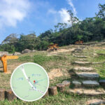
🥾 Lantau Trail • Section 2 (Pak Kung Au → Sunset Peak)
- Route Characteristics: Postcard-perfect vistas featuring seas of golden silvergrass during autumn and winter.
- Difficulty: Moderate; features well-maintained stone steps but requires a steady ascent toward 869 metres.
- Key Highlights: Lantau Mountain Camp, Heaven Pool, and Nam Shan.
- Distance: Approximately 2 km
- Elevation Gain: Around 500 metres
- Duration: About 1–1.5 hours
- Highlights: Shimmering silvergrass meadows and the historic stone cabins of Lantau Mountain Camp.
🌄 Lantau Trail • Section 3 (Pak Kung Au → Lantau Peak)
- Route Characteristics: A legendary route for sunrise chasers, offering majestic cloud-sea views.
- Difficulty: Strenuous; heavily stepped with steep alpine inclines.
- Endpoint: Terminates at Ngong Ping, where hikers can visit the Tian Tan Buddha and Wisdom Path.
- Distance: Approximately 2.5 km
- Elevation Gain: Around 600 metres
- Duration: About 1.5–2 hours
- Highlights: Conquering Hong Kong’s second-highest summit and experiencing breathtaking alpine sunrises.
🌳 South Lantau Country Trail (Pak Kung Au → Mui Wo / Nam Shan)
- Route Characteristics: Gentle, winding slopes ideal for beginners and casual walkers.
- Scenery: Offers broad views looking down across the southern coastline and Cheung Sha Beach.
- Distance: Approximately 6.5 km
- Difficulty: Easy to Moderate (mostly a gradual descent)
- Duration: About 2–2.5 hours
- Highlights: Fully shaded woodland paths, serene mountain streams, and straightforward transport connections.
—
🧤 Gear & Safety Tips
- Essential Packing: Sturdy hiking boots, windproof jacket, headlamp, trail snacks, ample water, offline trail maps, and trekking poles.
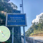
- Weather Awareness: Due to the saddle topography, be prepared for sudden temperature drops and fierce wind-chill effects at the pass.
- Heritage Conservation: Do not climb on top of the historic stone cabins at Lantau Mountain Camp; respect and preserve these historical structures.
- Crowd Management: The trail becomes exceptionally crowded during peak silvergrass season. Always practice trail courtesy and exercise caution when taking photos along steep edges.
— Pak Kung Au stands as a pivotal hub in Hong Kong’s trail network. Serving as the boundary line between Sections 2 and 3 of the Lantau Trail, it connects the island’s most coveted trekking paths. It is not only the launching pad for scaling Sunset Peak (Hong Kong’s third-highest peak, world-famous for its autumnal silvergrass) and Lantau Peak, but also opens up pathways to surrounding relics like the stone cabins built by early 20th-century missionaries. In 2003, a Government Flying Service helicopter tragically crashed nearby during a rescue mission, claiming the lives of two crew members; a memorial plaque stands at the country park rest area to honor their sacrifice and service. —
🛫 Historical Events & Memorials
- 2003 Aviation Accident: Pak Kung Au was the site of a tragic Government Flying Service helicopter crash during an emergency operational flight, resulting in the loss of two dedicated crew members.
- The Memorial Plaque: A dedicated memorial has been erected within South Lantau Country Park to pay tribute to the fallen officers, while serving as a poignant reminder for hikers to respect nature and prioritize safety.
—
🧭 Topography & Natural Highlights
- The Grand Alpine Saddle: Perfectly cradled between Lantau Peak and Sunset Peak, two of the highest stand-alone mountains in Hong Kong.
- Wind-Funnel Effect: The natural mountain gap acts as a geographical funnel, creating pronounced, refreshing crosswinds through the pass.
- Vantage Vistas: Provides sweeping, unobstructed views stretching across Lantau Peak, Sunset Peak, Tung Chung New Town, and the airport.
- Seasonal Foliage: The high-altitude slopes come alive with blooming silvergrass in late autumn, turning the entire landscape into a golden-hour sanctuary for photographers.
—
📸 Silvergrass Season Photography Guide
Time Slot Composition & Lighting Strategy Dawn / Early Morning Capture early sunbeams piercing through low-hanging mist and cloud seas; offers incredibly soft, ethereal lighting. Mid-to-Late Afternoon Shoot facing into the sun (backlighting) to make the silvergrass feathers glow with a brilliant, translucent golden hue; excellent for dramatic silhouettes. Dusk / Golden Hour Capture the deep crimson sunset blending into the fields of silvergrass, creating an incredibly romantic, sweeping cinematic mood. —
🗓️ Best Seasonal Windows
Season Landscape Highlights Trail Recommendations Autumn (Oct–Dec) Feathery silvergrass blooming across entire ridges, turning fields a shimmering gold. The absolute premier window for landscape photography and peak trekking. Winter (Jan–Feb) Crisp, cold air masses increase the likelihood of spectacular alpine cloud-seas. Perfect for catching clear, crisp sunrises over the mountain ranges. Summer (Jun–Aug) High humidity, intense heat index, and frequent tropical thunderstorms or lightning. Highly discouraged for high-altitude ridge climbing due to exposure. —