🏞️ 【Tai Tam • Reservoir (大潭 • 水塘 – A Milestone in Hong Kong Waterworks)】 is one of the most historically significant water supply systems in Hong Kong. Tucked away inside Tai Tam Country Park in the Southern District of Hong Kong Island, this network is made up of four interconnected reservoirs (Tai Tam Upper Reservoir, Tai Tam Byewash Reservoir, Tai Tam Intermediate Reservoir, and Tai Tam Tuk Reservoir), built in stages between 1888 and 1917. This group of reservoirs stands as a classic masterpiece of early modern infrastructure in Hong Kong, with its massive stone-masonry dams, arched bridges, and aqueducts all built using Victorian-era engineering. In 2009, the entire complex was listed as a Declared Monument, making it the very first waterworks facility group in Hong Kong to receive this honor. Among them, the main dam of Tai Tam Tuk Reservoir stretches a whopping 492 feet, making it the longest arched gravity dam of its kind in Asia at the time.
📌 Quick Facts
Item Details 📍 Location Southeastern part of Hong Kong Island, inside Tai Tam Country Park. It spans across the Southern and Eastern Districts, right next to Mount Butler, Jardine’s Lookout, Violet Hill, and Mount Parker. 🏗️ Construction Period Built in phases: Work kicked off in 1883, with Tai Tam Upper Reservoir completed in 1888, and the entire project wrapping up with Tai Tam Tuk Reservoir in 1917. 💧 Reservoir Network Consists of four reservoirs: Upper, Byewash, Intermediate, and Tuk, serving up a total storage capacity of around 8,303,000 cubic meters. 🧱 Engineering Feats Marked the first use of drilling rigs to build Hong Kong’s very first water tunnel, and featured the largest concrete dam in the British colonies at the time. 🏛️ Declared Monuments A total of 21 waterworks structures within the reservoir network are listed as Declared Monuments, including stone bridges, dams, and pumping stations. 🧭 Geographical Setting Situated in the low-lying Tai Tam Valley and surrounded by high mountains on all sides, creating a perfect natural catchment area for a reservoir. 🌿 Eco Highlights The Tai Tam Bay wetlands boast the only mangrove community on Hong Kong Island, featuring rare species like Kandelia obovata and Lumnitzera racemosa, and serving as a home to fiddler crabs and wetland crabs. 🚶♂️ Heritage Trail The Tai Tam Waterworks Heritage Trail is about 5 km long, linking all 21 historic structures. It takes about 2 hours to walk and has clear info boards along the way. 🧑🔬 Historical Impact A massive milestone for Hong Kong’s public water supply system, which vastly improved hygiene on HK Island and powered the city’s urban growth. 🧑🎓 Key Engineer Tai Tam Tuk Reservoir was designed by Chief Engineer Daniel Jaffe—and yes, Jaffe Road in Wan Chai is named right after him. 🚌 Getting There Hop on Bus 14 and get off at the “Tai Tam Country Park” stop. Alternatively, you can drive up, as some sections have parking spaces available. — Tai Tam Reservoirs are not just an engineering wonder—they blend beautifully with the surrounding nature. The reservoir network is ringed by dense secondary forests, feeding multiple eco-rich streams that are home to native wildlife like barking deer, long-tailed macaques, and Hong Kong’s very own Romer’s tree frog. The area features an excellent trail network, including Tai Tam Reservoir Road and the Tai Tam Country Trail, where you can enjoy stunning views of the grand dams reflecting on the glassy lake water. The section linking Wong Nai Chung Gap and Tai Tam Tuk is also a massive hotspot for cycling and hiking, showcasing a beautiful harmony between history and nature. —
💧 Reservoir Network
Tucked away in the southeastern part of Hong Kong Island, the Tai Tam Reservoir group is one of the earliest public water supply systems in Hong Kong, taking 35 years to complete between 1883 and 1917. It is made up of four reservoirs:
Reservoir Name Year Completed Highlights Upper Tai Tam Reservoir 1888 The first one built, with a capacity of 1.36 million cubic meters Byewash Reservoir 1904 Built to catch the overflow water from the Upper Reservoir Intermediate Reservoir 1907 Requires water to be pumped up to the upstream supply system Tai Tam Tuk Reservoir 1917 The biggest reservoir of the bunch, holding 6.45 million cubic meters — Standing as living proof of Hong Kong’s water supply history, the Tai Tam Reservoirs are still fully operational today and are open to the public via the Tai Tam Waterworks Heritage Trail. The trail features 21 information stops that dive deep into the engineering details and historical value of the dams, valve houses, and stone bridges. For transport, you can easily catch a bus or minibus from MTR Shau Kei Wan Station, making it super convenient for anyone to explore this historical landmark that perfectly blends engineering aesthetics, eco-conservation, and leisure. —
🏗️ History & Engineering Background
🔹 Why It Was Built
- Because Pok Fu Lam Reservoir didn’t have enough storage capacity, the Hong Kong government appointed Surveyor-General J.M. Price in 1873 to scout for new water sources.
- He suggested building a new reservoir in Tai Tam Valley because of its high elevation and massive catchment area.
🔹 Engineering Challenges
- To channel water all the way to the northern side of Hong Kong Island, they had to cut right through Jardine’s Lookout to build a water tunnel.
- They also had to construct the Bowen Aqueduct to link it up to the Albany Filter Beds.
🔹 Design Features
- The dams were built using granite and concrete, making the structures incredibly solid.
- The Tai Tam Tuk Dam was hailed as the “First Dam of Asia.” It was designed by engineer Daniel Jaffe, and Jaffe Road was named in his memory.
—
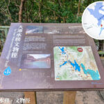
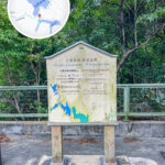
🏛️ Waterworks Heritage Trail
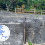
This 5 km trail strings together 21 Declared Monuments, including:
Structure Name Highlights Tai Tam Tuk Pumping Station A classic red-brick building that is still up and running today Granite Bridges Century-old stone bridges with beautiful arched structures Dams & Overflow Channels Creates a spectacular waterfall view during the rainy season Bowen Aqueduct An impressive cross-mountain water channel Recording Instrument House Used for monitoring water levels and flow rates 👉 This heritage trail doesn’t just display engineering skills—it’s living history showing how Hong Kong’s water supply evolved. —
🌿 Nature & Landscape
🔹 Eco-Environment
- The habitat is packed with trees like Sweet Gum and Paperbark.
- Common wildlife spotted here include squirrels and seasonal Black-faced Spoonbills.
🔹 Views Through the Seasons
- 🍁 Autumn: The Sweet Gum leaves turn a gorgeous fiery red, making it a massive hotspot for photos.
- 🌧️ Rainy Season: The reservoir overflows, turning the dams into epic, roaring waterfalls.
- 🌸 Spring: Wildflowers hit full bloom, bringing the whole trail to life.
—
🚶♂️ Hiking & Transport
🔹 Recommended Route
- Starting Point: Tai Tam Country Park Entrance
- Route: Tai Tam Tuk Dam → Granite Bridges → Pumping Station → Intermediate Reservoir
- Time: Around 2–3 hours | Difficulty: ⭐⭐ (Moderate)
🔹 Getting There
- Bus: Citybus Route 14 (kicks off from Sai Wan Ho / Stanley)
- Taxi or Driving: You can find some parking spots near Stanley Gap Road
—
📜 Cultural & Historical Value
- The Tai Tam Reservoir network is one of Hong Kong’s very first public water supply systems.
- The entire complex was officially listed as a Declared Monument in 2009.
- The pumping station was even used as a filming location for the famous HK movie “Cold War 2,” making it a true cultural landmark.
—
🧭 Fun Trivia
- The old HK ten-dollar note featured the famous “Ah Queen Leading the Way” drawing, which shows a local villager guiding British merchants through the Tai Tam hills to do business—a classic symbol of East-meets-West history.
- Tai Tam Tuk Reservoir was originally designed to be built right on the sea. If it had succeeded, it would have been the world’s very first marine reservoir!
—