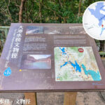
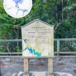
🌊 【Tai Tam】is located in the southeastern part of the Southern District on Hong Kong Island. It is an area that seamlessly blends natural ecosystems, colonial history, and modern luxury residences, with the Tai Tam Reservoirs group serving as its core scenic landscape. This group of reservoirs includes the Tai Tam Upper, Tai Tam Byewash, Tai Tam Intermediate, and Tai Tam Tuk reservoirs. Built between 1888 and 1917, they were once the primary source of fresh water for Hong Kong Island. Today, along with 21 surrounding historical waterworks structures, they are declared monuments of Hong Kong, forming the famous “Tai Tam Waterworks Heritage Trail”. During the rainy season, the 12 spillways of the Tai Tam Tuk Reservoir dam create a spectacular man-made waterfall, drawing numerous photography enthusiasts to capture this stunning marvel where nature meets engineering. —
📍 Geographical Location
- Location: East of Stanley, west of Shek O
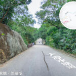
- Main Road: Tai Tam Road
- Neighboring Areas:
- North: Chai Wan
- South: Red Hill Peninsula
- East: Tai Tam Harbour, Tai Tam Bay
- West: Tai Tam Reservoirs group
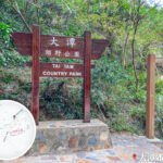
— The 【Tai Tam】 area is enveloped by Tai Tam Country Park and sits adjacent to Mount Butler, Jardine’s Lookout, and Mount Violet, boasting rich ecological resources and multiple hiking paths. It is easily accessible by taking bus route 14 from Sai Wan Ho. The tree-lined journey offers both the serene beauty of the reservoirs and sweeping views of the mountains and seas of eastern Hong Kong Island, making it an ideal getaway for residents looking to escape the city’s hustle and bustle and enjoy nature. —
🗺️ Geographical & Environmental Overview
Item Details District Southern District Nearby Locations Stanley, Shek O, Cape D’Aguilar Bays Tai Tam Harbour, Tai Tam Bay Mountain Ranges The Red Hill (Pak Pat Shan), Mount Butler Country Park Tai Tam Country Park —
🏗 Historical Background & Development
- Origin of Name: Tai Tam – translates to “a large expanse of deep water”, referring to the triangular marine area enclosed by the Stanley Peninsula, Cape D’Aguilar Peninsula, and Tai Tam Tuk.
- Historical Records: “Tai Tam” was already documented in the Ming Dynasty’s “Yue Da Ji”; an American captain refueled and gathered supplies here in 1792.
- Colonial Era Planning: The British originally considered establishing their administrative centre here before opting to build the City of Victoria on the north shore instead.
—
🏞 Natural Ecosystems & Landscapes
- Area: Approximately 1,243 hectares
- Landscape Features: Surrounded by high mountains; rainwater aggregates to form streams and reservoirs
- Primary Habitats: Secondary forests, shrublands, freshwater streams, and reservoirs
- Biodiversity: A vital habitat for the Hong Kong Newt
—
💧 Tai Tam Reservoirs
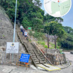
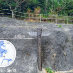
Reservoir Year Built Highlights Tai Tam Upper Reservoir 1883–1888 Hong Kong’s second reservoir, featuring stone-masonry aqueducts. Tai Tam Intermediate Reservoir 1904–1907 Granite dam that creates a beautiful waterfall effect during the rainy season. Tai Tam Byewash Reservoir 1904 Built for overflow purposes; a smaller dam with a great autumn foliage spot nearby. Tai Tam Tuk Reservoir 1912–1917 Features a spectacular main dam, pumping station, stone bridges, and 12 granite arched spillways. —
🧱 Declared Monuments
- Stone Bridges: Built in 1907, featuring elegant granite arched structures.
- Pumping Station: A classic red-brick building topped with traditional Chinese tiled roofs.
- Staff Quarters: Features red-brick walls, wooden windows, and circular arched roofs.
—
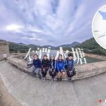
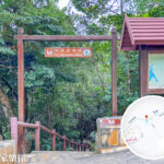
🚶♀️ Recommended Hiking Route
🔹 Tai Tam Waterworks Heritage Trail
- Starting Point: Tai Tam Country Park South Gate
- Ending Point: Wong Nai Chung Gap
- Distance: Approx. 5–6 km
- Duration: Approx. 2–4 hours
- Difficulty: ⭐ 1 Star (Perfect for beginners)
- Highlights: Tai Tam Tuk Reservoir main dam, century-old stone bridges, autumn foliage spots, and waterfall vistas.
—
🚌 Transport
From Bus Route Alighting Point Sai Wan Ho Citybus Route 14 Tai Tam Country Park Stop Stanley Citybus Route 314 (Seasonal) Along Tai Tam Road Shau Kei Wan / Siu Sai Wan Citybus Route 14 / Route 314 Tai Tam Reservoir Entrance or Tai Tam Country Park Stop —
🌉 Must-See Spots
- Tai Tam Tuk Reservoir Dam: Features 12 magnificent granite arched spillways.
- Century-Old Stone Bridges: A series of 4 beautiful granite arched bridges.
- Autumn Foliage: Sweet Gum trees located right next to BBQ Site No. 4.
—
🏕 Modern Facilities & Community
- Tai Tam Scout Centre: Offers camp facilities and accommodation right next to local mangroves.
- Hong Kong International School (HKIS): Provides primary and secondary education.
- Residential Areas: Home to low-density luxury residential areas like Red Hill Peninsula, Turtle Cove, Leisureside, and Rosecliff.
- Mangrove Ecosystems: Distributed along the shores of Tai Tam Harbour.
—
📚 Historical Trivia
- The place name “Tai Tam” was already recorded in the Ming Dynasty map “Yue Da Ji”.
- “Tai Tam Tuk” and “Tai Tam Tau” represent the northernmost and southernmost tips of old Tai Tam respectively.
- In the 18th century, Tai Tam Bay was the main port on the southern shore of Hong Kong Island, known back then as “Hong Kong Harbour”.
- When the British first founded the colony, they considered establishing their administrative centre on the south shore, but ultimately chose the north shore (City of Victoria) due to the rugged southern terrain.
—