🌿 【Tai To Yan Path (大刀屻徑)】is one of Hong Kong’s most challenging hiking trails, famous for its razor-sharp ridges. Along the way, you can get stunning bird’s-eye views of the Yuen Long Plain, Lam Tsuen Valley, and even see as far as Shenzhen. The entire hike is about 9–10 km and takes around 3.5–4.5 hours. It’s an intermediate-to-advanced route, making it perfect for seasoned hikers. —
📍 Geographic Info
Item Details Location Lam Tsuen Country Park Starting Point Kadoorie Farm & Botanic Garden (Lam Tsuen, Tai Po) Ending Point Fanling MTR Station Total Length Approx. 8.8–10 km Time Required 3.5–4.5 hours Difficulty Intermediate to Advanced Highest Peak Tai To Yan, 565m above sea level Connected Peak Pak Tai To Yan (479m) —
📖 Origin of the Name
- Razor-sharp Ridge: Named after its narrow, blade-like mountain ridges.
- Alias “Tai Tau Yeung” (Big Headed Goat): The twin peaks look just like a pair of goat horns, giving it a distinct silhouette.
- Historical Name “Tshai To Ngin”: “Ngin” is a Hakka dialect word for ridge, which later evolved into “Tai To Yan” in Cantonese.
—
—
🚍 Getting There & Away
Section Transport Start: Kadoorie Farm MTR Tai Po Market Station → Take Bus 64K → Alight at Kadoorie Farm stop End: Fanling Station Follow the trail downhill → Walk towards Fanling Town Centre → MTR Fanling Station —
🌄 Highlights & Scenery
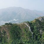
- Knife-Edge Ridge: The mountain ridge is incredibly narrow with steep drops on both sides, offering spectacular views.
- Panoramic Views: Overlook the Yuen Long Plain, Lam Tsuen Valley, Tai Mo Shan, and catch views of Shenzhen in the distance.
- Natural Ecosystem: Lam Tsuen Country Park is home to over a thousand plant species, butterflies, insects, and wildlife.
- Stunning Landscapes: Features rugged boulders, moss-covered valleys, and dense woods filled with wild mushrooms along the trail.
—
🚶♂️ Route Breakdown
🚩 Starting Point: Kadoorie Farm
- The trailhead starts right across the road from the entrance.
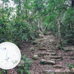
🪜 The First Stretch: Dense Woods & Stair Challenge
- Expect lots of continuous, steep stone steps that will really test your stamina.
- After about half an hour, you’ll reach a small hill where you can look back at Kwun Yam Shan and Tai Mo Shan.
🗡️ Mid-Section: Tai To Yan Ridge
- The ridge gets as narrow as a knife’s edge with steep slopes on both sides.
- The views here are epic, looking straight down at the Yuen Long Plain and Lam Tsuen Valley.
🌄 Pak Tai To Yan (North Tai To Yan)
- Standing at 479m, it is connected to the main peak.
- From here, you can see across to Kai Kung Leng and downtown Shenzhen.
🏁 Ending Point: Fanling Station
- The entire hike takes about 4–4.5 hours.
—
📌 Quick Tips
- Sun protection is a must: Bring a hat, sunglasses, and sunscreen.
- Demanding on stamina: The stairs at the beginning are brutal, so pace yourself.
- Best season to go: Autumn and winter, when the weather is cooler and visibility is clear.
—
⚠️ Things to Note
- Physically demanding: You’ll face endless stairs followed by an exposed ridge walk with zero shade, so pack plenty of water and sun protection.
- Few bailout points: The trail is quite isolated with very few exit routes, so make sure you’re mentally prepared.
- Refuel tips: You can grab a bite to eat at the Kadoorie Farm vegetarian canteen before you hit the trail.
- Safety first: The ridge is very narrow; if it gets windy, slow down and watch your step to avoid slipping.