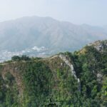
⛰️ 【Tai To Yan (大刀屻)】 is a mountain ridge in the northern part of the New Territories, Hong Kong. Standing at an elevation of 566 meters within the Lam Tsuen Country Park, it is the ninth-highest peak in Hong Kong and derives its name from its razor-sharp ridge lines that resemble a knife’s edge. The mountain features two distinct peaks: South Tai To Yan (the main summit) and Pak Tai To Yan (the secondary peak, at 479 meters). Its narrow and rugged ridge lines were historically dubbed a “natural hazard” by early hikers, though the government has since installed safety handrails along the most exposed sections. The summit offers sweeping 360-degree vistas overlooking the Yuen Long Plain, Lam Tsuen Valley, Tai Mo Shan, and the Shenzhen border. The stunning view of sunset glows painting the rolling hills makes it celebrated as one of Hong Kong’s premier hiking destinations. —
🗺️ Basic Information
📌 Item 📍 Details 🏞️ Chinese Name 大刀屻 (Also known as 剃刀屻, 橫台山, 尖山洞) 🌐 English Name Tai To Yan 📍 Location Northern New Territories, within Lam Tsuen Country Park; spans across North District, Tai Po District, and Yuen Long District ⛰️ Elevation Main summit is approx. 566 m (Hong Kong’s 9th highest peak); secondary peak (Pak Tai To Yan) is approx. 480 m 🗺️ Terrain Features Steep, knife-like ridges on both sides; the main and secondary peaks are separated by roughly 2.4 km; features expansive views of Yuen Long Plain, Ma On Shan, and Shenzhen 🚶♂️ Trail Starting Points Kadoorie Farm, Pak Ngau Shek (Kiu Tau), or Kei Lak Tsai ⛰️ Hiking Highlights Narrow ridges, magnificent vistas, shaded forest sections, blooming wild azaleas (spring), and rich biodiversity 🧭 History & Naming Originally named “Tai Do Yan” (剃刀屻 – Razor Ridge); the Hakka pronunciation for “razor” was transliterated as “Tai” by colonial officials, which later translated back into Chinese as “大刀屻” (Big Knife Ridge) and became the official name — The typical hiking route up Tai To Yan kicks off from Kadoorie Farm, climbing up steep stone steps to the main summit before traversing Pak Tai To Yan and Kei Lak Tsai (256 m), then descending into Fanling. The entire trail spans roughly 9 km and takes about 4 to 5 hours to complete. Classified as a moderate-to-difficult hike, the initial section requires a continuous 300-meter vertical ascent, and large portions of the ridge are entirely exposed to the elements with high sun exposure—making it best suited for hikers with decent physical stamina. The area boasts a rich ecosystem where lucky hikers might spot pangolins, wild boars, and a diverse array of butterflies. Nestled at the foot of the mountain, Kadoorie Farm offers quick refreshments and environmental exhibits, making it an excellent staging ground before setting off. —
📜 Origins & Historical Trivia
- The peak’s original name was “剃刀屻” (Razor Ridge), capturing the sharp, razor-thin profile of the mountain spine.
- British colonial officials transliterated the Hakka spoken word for razor (“Tei”) into the English phonetic “Tai,” which mapmakers subsequently translated back into Chinese characters as “大刀屻” (Big Knife).
- Local traditional names include “Wang Toi Shan” (Flat Table Mountain) and “Tsim Shan Tung” (Sharp Mountain Peak).
- Historically, it was occasionally misheard or recorded as “大頭羊” (Big-headed Sheep) or “大炭秧” (Big Charcoal Seedling) by travelers! 🤣
— The history of Tai To Yan is deeply intertwined with local Hakka culture, and old agricultural terrace ruins can still be spotted around the neighboring Wang Toi Shan villages. Thanks to the growing popularity of hiking, the main trail has become well-trodden and distinct, though some off-shoot wild paths remain treacherous. Hikers are strongly urged to bring plenty of food and water and to avoid trekking alone. Blending rugged natural terrain, local cultural heritage, and ecological wonders, this ridge stands out as a classic route for experiencing the diverse charm of Hong Kong’s wilderness. —
—
🥾 Detailed Hiking Route Breakdown
Trail Section English Name / Landmark Key Features 嘉道理農場 Kadoorie Farm The starting point; features a vegetarian kiosk and nature education exhibits. 大刀屻主峰 Tai To Yan Peak Standing at 566 m; boasts a narrow, dramatic ridge walk with epic panoramas. 北大刀屻 Pak Tai To Yan Standing at 479 m; looks out over Shenzhen and Kai Kung Leng. 粉嶺市區 Fanling Town The trail terminus; offers easy transport links, local cooked food centers, and heritage buildings.
- Total Distance: Approx. 10 km
- Time Required: Around 4 hours
- Difficulty Level: Challenging (Recommended for seasoned hikers)
—
🧗♀️ Trail Navigation Guide
- 🔰 The Start: Opposite the main entrance of Kadoorie Farm, you will find a rain shelter; follow the directional signpost to head up the stone steps.
- 🪨 The Summit: South Tai To Yan features a trigonometric triangulation station (No. 415), where the ridge shrinks to a knife-like edge.
- 🏞️ The Secondary Peak: Pak Tai To Yan stands at 479 m, providing an open vantage point over Kai Kung Leng and the Shenzhen city skyline.
- 🦶 The Descent: Branching trails such as the Wu Tip Shan Trail, Kei Lak Tsai, or Pak Ngau Shek provide various routes leading down into Fanling.
—
🌄 Landscapes & Wildlife Echoes
- **Scenic Vistas:** Looks west out across Pat Heung and the Yuen Long Plain, east toward Tai Po and Ma On Shan, and north into downtown Shenzhen.
- **Biodiversity:** Home to countless butterflies, unique insects, and wild birds, along with over a thousand native plant species.
- **Freshwater Streams:** The Sheung Yeung Stream flows directly from the valley between the north and south peaks.
—
⚠️ Safety & Practical Tips
- While the exposed ridge was once feared as a “natural hazard,” the government has since installed chain-link handrails (commonly called the Gold and Silver Bridge) for safety.
- It is strongly recommended to wear hiking shoes with excellent grip, carry plenty of drinking water, and bring ample sun protection.
- **Transport:** Take KMB Route 64K and get off at the Kadoorie Farm bus stop to start; you can easily head home from the Fanling MTR Station at the end.
—
🌿 Natural Ecology & Scenic Highlights
🦋 Rich Biodiversity
- Over a thousand species of indigenous flora.
- Abundant butterflies, dragonflies, and mountain insects.
- Local wildlife sightings including wild squirrels, boars, and diverse bird species.
🌄 Panoramic Vistas
- Yuen Long Plain
- Lam Tsuen Valley
- Shenzhen Skyline
- Tai Mo Shan
—
🍽️ Food & Rest Recommendations
- The vegetarian kiosk inside Kadoorie Farm serves organic sandwiches, omelets, fresh salads, and coffee.
- There are absolutely no replenishment points along the main mountain trail, so be sure to pack your own trail mix and water.
- Upon reaching the end, the Luen Wo Hui Cooked Food Centre in Fanling is a fantastic spot to grab a hearty local meal.
—
🚦 Safe Trekking Practices
- Always gear up with high-traction trail or hiking shoes.
- Be especially mindful of sunstroke and dehydration during hot summer months.
- Even though the ridge path is equipped with guard rails, maintain focus and watch your step.
- Novices are highly encouraged to hike in groups or join guided outdoor excursions.
—
🧭 Extended Exploration
Location Key Highlights & Distinctions 🏞️ Ngau Kwu Kok An ancient village heritage site; its stream forms the upper reaches of the Ngau Tam Mei River, with faint old terrace lines visible on the hillsides. 💧 Sheung Yeung Stream Originating directly from the peaks of Tai To Yan, this stream boasts steady water flows and incredibly tranquil valley scenery. 🏛️ HKFYG Leadership Institute A beautifully revitalized historic building that originally served the community as the old Fanling Magistracy. —