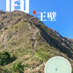
🧗♂️ 【Yan Wong Wall】 is a narrow ridge on Lantau Island’s Kau Nga Ling (Dog’s Teeth Range), connecting the West and Central “Dog’s Teeth” segments. It gets its name from being so narrow that only one person can pass through at a time. This is the most perilous section of Kau Nga Ling; both sides are sheer cliffs, and a single misstep could be fatal. Serious accidents, some tragic, have occurred here in the past. Therefore, this route is strictly for experienced, physically fit hikers who have proper safety gear and support—never attempt this during bad weather. The “Thread of Life” (Yat Sin Sang Gei) is widely considered one of the most challenging hikes in Hong Kong—a true “rite of passage” to test your hiking mettle.
📌 Quick Facts
Feature Details 📍 Location Between the West and Central “Dog’s Teeth” of Kau Nga Ling, Lantau Island ⛰️ Elevation Approx. 800m, near Tsam Chai Au (Peak approx. 810m) 🧙♂️ Origins Legend has it that the King of Hell (Yan Wong) once cultivated himself here, hence the name “Yan Wong Wall.” 🗺️ Distance Approx. 7.45 km, takes about 5.5 hours 📐 Terrain Steep rock faces, scree slopes, cliff edges, narrow passes ⚠️ Difficulty Extreme—for experienced hikers with proper gear only 🧗♀️ Technical Requires scrambling on scree and cliff edges; sections only wide enough for one 🌉 Key Spots The “Thread of Life” narrow pass; the “Bird Rock“ 🌄 Scenery Views of Lantau Peak, Shek Pik Reservoir, Soko Islands; jagged peaks like dog’s teeth 🎒 Gear Grip-sole hiking shoes, gloves, trekking poles, headlamp, plenty of water & food 🌧️ Weather Avoid in rain (scree becomes dangerously slippery); visibility poor in mist 👥 Safety Go with a group, never alone. Not for those with a fear of heights. —
—
🧙♂️ Legend & Naming
The name “Yan Wong Wall” comes from a local legend: it is said that the King of Hell once practiced here before ascending to immortality. Its ruggedness and eerie atmosphere earned it this name, making it a “sacred” spot for hardcore hikers. The legend adds a layer of mystery, suggesting the trail is like walking the edge of hell, requiring a spirit as strong as a “rebirth” to conquer. Hikers hold this place in deep awe. —
🚍 Getting There
Starting Point: Shek Pik Police Post
- Take Lantau Bus 11 or 23 from Tung Chung and get off at the “Shek Pik Police Post.”
- Follow the “Shek Pik Country Trail” to reach the entrance of Kau Nga Ling.
Endpoint: Ngong Ping
- After finishing the hike, take the cable car or bus back to Tung Chung.
—
🏞️ Landscape Highlights
Yan Wong Wall is part of the Kau Nga Ling range. It features dramatic, jagged terrain:
- “A Thread of Life” : A narrow rock path between two sheer drops, dubbed the “Life or Death Bridge.”
- Bird Rock : A massive boulder shaped like a bird looking back—a key landmark.
- Lantau Peak Views : Wide, panoramic views of Hong Kong’s second-highest peak.
- Shek Pik Reservoir & Soko Islands : Stunning vistas of the water and islands.
- Scree Slopes : Loose rocks; require careful scrambling and high caution.
- Tsam Chai Au : At 810m, it’s the highest point of the West Kau Nga segment.
—
🌅 Scenic Beauty
Beyond the danger, the views are breathtaking:
- 🏞️ Kau Nga Ling Range : Dramatic, razor-sharp ridges.
- 🌊 Shek Pik Reservoir : Mirror-like water set against the mountain landscape.
- 🏝️ Soko Islands : Looking out over the South China Sea.
- 🏔️ Lantau Peak : Sweeping silhouettes of the mountain.
—
🧗♂️ Route Guide & Analysis
🔹 Start: Shek Pik Police Post
- Take Lantau Bus 11 or 23 from Lantau Island (via Tung Chung) to the Police Post.
- Follow the trail into Kau Nga Ling.
🔹 Climbing West Kau Nga
- Slope angle is 60–70 degrees; get ready to use your hands.
- Vertical but with good hand/foot holds; remember the “three-points-of-contact” rule.
🔹 Main Yan Wong Wall Section
- 50–60 degree incline; over 700 meters long.
- Mostly rocky, requires steady balance and focus.
- Great spot mid-way to look back at the jagged range.
🔹 End: Tsam Chai Au → Ngong Ping Village
- Tsam Chai Au (810m) is the summit point.
- You can continue to Lantau Peak or descend via Lantau Trail Section 3 to Ngong Ping.
—
🛠️ Gear Recommendations
Item Reason 🥾 Grip-sole Boots Essential for steep slopes and loose rocks. 🧤 Gloves Protect hands while scrambling over rocks. 🔦 Headlamp Essential for visibility if dusk hits. 💧 Water/🍞 Food Zero supply points—carry everything you need. 🩹 First Aid Kit For minor cuts or strains. 🦯 Poles Helpful for balance and saving the knees. —
⚠️ Safety Notes
- Never go in the rain—scree slopes turn lethal.
- Avoid solo hiking—go with a group and let someone know your itinerary.
- Signal can be patchy; bring offline maps or a GPS watch.
- High physical demand; only attempt if you’ve conquered similar routes.
- Not for those with acrophobia (fear of heights)—no railings on many sections.
- Start early and allow plenty of time—no night hiking.
—