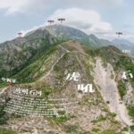
🐶【Kau Nga Ling】(狗牙嶺)is a famous mountain ridge in southern Lantau Island, Hong Kong. Standing at an altitude of 539 meters, it is a southern offshoot of Lantau Peak, situated south of Lantau Peak’s summit and east of Shek Pik Reservoir. The ridge gets its name (which translates literally to “Dog’s Teeth Ridge”) from its jagged, sharp, and narrow topography that resembles the teeth of a dog. 【Kau Nga Ling】 boasts three famous ridges: West Kau Nga, Middle Kau Nga, and East Kau Nga, and is widely considered a “qualification-testing route” within the Hong Kong hiking community. The highest point of the ridge (539 meters) is located along the Middle Ridge. The most perilous section of Kau Nga Ling lies at the junction of the West Ridge and Middle Ridge—a section of the ridge line so narrow that it allows only one person to pass at a time, known among hikers as the “Lifeline” (一線生機).
🗺️ Geography & Basic Information
Item Details English Name Kau Nga Ling (Dog’s Teeth Ridge) Location Southern Lantau Island (South of Lantau Peak, East of Shek Pik Reservoir) Highest Point 539 meters (Located along the Central / Middle Ridge) Main Ridges West Ridge, Middle Ridge, East Ridge Topographical Features Three distinct ridge lines; sharp and narrow crests resembling dog teeth with scattered precipices; dangerous section named “Lifeline“ Type High-difficulty natural mountain trail, unmaintained by official authorities Difficulty ⭐️⭐️⭐️⭐️⭐️ (Ranked as one of Hong Kong’s most dangerous hiking trails) 🏞️ Topographical Characteristics of Kau Nga Ling
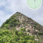
- Sharp Ridges: The crests are sharply serrated like canine teeth, representing the most prominent feature of Kau Nga Ling.
- Steep Cliffs: Deep valleys flank both sides of the ridge. Certain sections are nearly vertical, requiring extreme caution while traversing.
- Scree Slopes: The ridges are heavily carpeted with loose gravel and shifting rock debris, increasing both the difficulty and danger of the trek.
—
—
🚶♂️ Hiking Route Overview
- Route: Shek Pik Reservoir → Shek Pik Country Trail → West Kau Nga Ling → Lifeline → Yim Wong Pik (Hades’ Wall) → Bird Rock → Tsam Chai Au → Ngong Ping
- Distance: Approx. 8 km
- Duration: Approx. 4 – 4.5 hours
—
💪🏻 Route Difficulty & Challenges
The route along Kau Nga Ling is extremely demanding and rated as an “extreme challenge level,” making it suitable only for experienced hikers who are thoroughly equipped. Below are the primary characteristics of this trek:
- Route Length & Time: The entire journey spans roughly 7.45 kilometers and takes approximately 5.5 hours to complete.
- Ascent & Descent: Features a total elevation gain of about 600 meters and a descent of around 500 meters. The substantial undulation imposes rigorous physical demands.
Hazards
- Sections of the path trace the very edges of sheer cliffs; it is entirely unsuited for those who suffer from vertigo or a fear of heights.
- Scree slopes offer highly unstable footing, making it remarkably easy to slip or trigger falling rocks. High alertness is required throughout.
—
🚌 Transportation
- Starting Point (Shek Pik Reservoir): Take New Lantao Bus routes 11 or 23 (departing from Tung Chung) or routes 1 or 2 (departing from Mui Wo), and alight at the Shek Pik Police Post stop.
- Ending Point (Ngong Ping): Board bus routes 2 or 23 to return to urban areas, or take the Ngong Ping 360 cable car down to Tung Chung.
—
🏞️ Scenic Highlights
Kau Nga Ling attracts an array of hardcore hikers and landscape photographers due to its breathtaking natural wonders. The signature landmarks include:
- Lifeline (一線生機): A narrow ridge walkway located along the middle section of the trail. The crest is only wide enough for a single person to step through, with precipitous drops on both sides, creating an intensely thrilling pass often likened to a “bridge of life and death.”
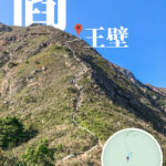
- Yim Wong Pik (閻王壁 / Hades’ Wall): One of the steepest and most grueling segments of the trek. It features a nearly vertical wall of rock climbing over an elevation of 100 meters, requiring hikers to scramble using both hands and feet.
- Bird Rock (小鳥回頭石): A distinct natural rock formation resembling a small bird turning its head back. Serving as an iconic landmark along the route, it is a favored photo stop and geographical reference point.
- Lantau Peak (鳳凰山): Traversing Kau Nga Ling provides an unobstructed, majestic vista of Hong Kong’s second-highest peak looming right ahead.
—
⛰️ Detailed Analysis of the Three Ridges
Ridge Characteristics Difficulty Level West Ridge (西狗牙嶺) Demands hands-and-feet scrambling right from the start. Flanked by massive boulder fields, it stands as the steepest incline. Extremely High Middle Ridge (中狗牙嶺) The overall slope is relatively more consistent, though it hosts the absolute highest peak of the mountain. Its convergence point with the West Ridge forms the famous “Lifeline“. High East Ridge (東狗牙嶺) Appears gentler from afar, but contains an intensely loose sand-and-gravel slope that makes losing traction and slipping highly probable. High —
⚠️ Trail Safety & Risks
- Unofficial Route: The trail is completely unmaintained by the AFCD. The terrain is highly rugged, heavily broken, and covered in crumbling rock.
- Extreme Difficulty: Rated ⭐️⭐️⭐️⭐️⭐️, it represents one of the most perilous trails in Hong Kong. It is strictly reserved for individuals with considerable experience in high-difficulty scrambling.
- Severe Risks: Shifting scree and shear exposures are constant. In 2017, a tragic fatal accident occurred when a hiker lost footing and fell from the “Lifeline” section.
- Recommended Gear: High-traction hiking footwear, protective gloves, and ample water and energy supplies are mandatory. It is best to start early in the day. The narrowest ridge sections must be crossed individually, and hikers should immediately retreat if encountering high winds or wet surfaces.
- Weather Restrictions: The ridge offers no shade, creating intense heat exposure during summer. Hiking here must be completely avoided during rainy seasons or thunderstorms.
- Exit Strategy: There are no intermediate bail-out paths or supply points. Once committed, hikers must push through all the way to Ngong Ping or Tsam Chai Au.