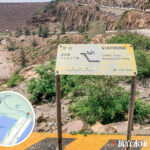
🌋【Geopark Trails】 are hiking routes introducing Hong Kong’s geological features and history, launched by the Hong Kong Geopark Management. The goal is to let the public appreciate and understand Hong Kong’s geological assets. There are 19 geopark trails in Hong Kong across different districts, including Sai Kung, Lantau Island, Hong Kong Island, Kowloon, and the New Territories. Each trail has a unique theme, such as volcanic rocks, granites, sedimentary rocks, wave-cut platforms, fossils, and minerals, complete with information boards, maps, and booklets. Hong Kong’s geopark trails cater to hikers of all levels—some are easy family walks, while others are more challenging and rugged, requiring scrambles or climbs. It is highly recommended to check route details and safety guidelines, and prepare enough gear and water before heading out.
- Total: Around 200 geosites and landform hotspots
- Rock Types: Igneous, sedimentary, and metamorphic rocks
- Geological Age: From Paleozoic to Cenozoic, covering over 300 million years of geological evolution
🪨 Major Rock Types in Hong Kong
- Igneous Rocks: e.g., the volcanic rock columns in Sai Kung
- Sedimentary Rocks: e.g., sandstone and siltstone in the Shuen Wan area
- Metamorphic Rocks: e.g., gneiss in the southern part of Hong Kong Island
—
🌊 Geopark Trails Intertwining Mountains and Seas
The Sai Kung Volcanic Rock Region showcases world-class volcanic landscapes, while Tung Ping Chau and Lai Chi Wo preserve precious sedimentary rock formations, ecology, and cultural heritage. These geopark trails are not just fields for scientific research, but also bridges for hikers to explore nature and culture. Walking along Hong Kong’s geopark trails, you can enjoy spectacular coastal scenery 🌊 while experiencing the profound connection between human heritage and nature. —
🗺️ Geographic Distribution & Iconic Trails
🔥 Sai Kung Volcanic Rock Region
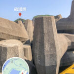
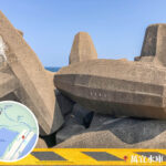
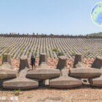
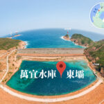
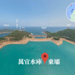
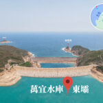
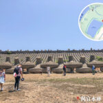
Highlights: World-class hexagonal volcanic rock columns, with an average diameter of about 1.2 metres and heights up to 100 metres.
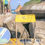
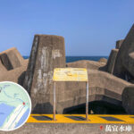
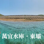
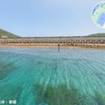
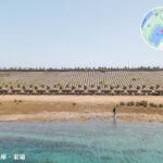
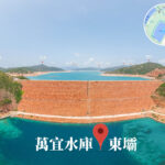
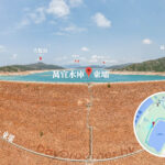
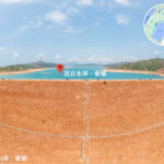
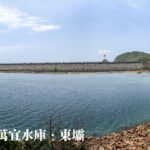
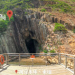
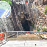
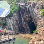
- High Island Reservoir East Dam: Hexagonal rock column clusters + sea caves
- High Island (Leung Shuen Wan): Mural-like natural rock column landscapes
- Sharp Island: Tombolo + granite “Pineapple Bun” rocks
- Tai Long Wan: Sea caves + beaches + surfing hotspot
- Po Pin Chau: Supervolcano relics + spectacular sea arch
- Ninepin Group: Secret spot featuring the hexagonal rock columns with the largest diameter
- Ung Kong Group: Four major sea arches + the tallest sea cliffs in HK
🪨 Northeast New Territories Sedimentary Rock Region
Highlights: Fully showcases 400 million years of Hong Kong’s geological history, with clear sedimentary rock sequences alongside fossils and unique landforms.
- Lai Chi Wo: Hakka walled village + mangroves + sedimentary rock landforms
- Tung Ping Chau: Laminated shale “Layer Cake” landform + intertidal ecology
- Ap Chau: Reddish-brown breccia + duck-shaped islet
- Wong Chuk Kok Tsui: Hong Kong’s oldest rocks + the iconic “Devil’s Fist” formation
- Double Haven: Sedimentary rock bay area + Marine Park
- Port Island: Unique red rock strata
—
🚶 Recommended Geopark Trails
Trail Region Distance Difficulty Highlights Double Haven Country Trail Northeast New Territories Approx. 8 km Moderate Hakka villages + siltstone coast High Island Reservoir East Dam Trail Sai Kung Approx. 3 km Easy Hexagonal rock columns + sea caves Tung Ping Chau Island Trail Northeast New Territories Approx. 6 km Moderate Laminated shale + intertidal ecology —
🌳 Hong Kong Geopark Facts
- Year Established: 2009; listed as a UNESCO Global Geopark in 2011
- Major Regions: Sai Kung Volcanic Rock Region, Northeast New Territories Sedimentary Rock Region
- Iconic Landforms: Hexagonal volcanic rock columns, sea caves, sea arches, laminated shale, red breccia
- Cultural Elements: Hakka walled villages, salt pan relics, Feng Shui woods