2020.05.03 SUN
【Hiking • 011】
Green Egg Island . Tai Au Mun . Clearwater Bay Equestrian Centre
綠蛋島 . 大坳門 . 清水灣騎術學校
This hiking route takes you on a deep dive into the natural beauty and hidden gems of Clear Water Bay. The entire journey takes approximately 5 to 6 hours, making it an ideal choice for hikers with a decent amount of experience and stamina. As there are no refill points along the trail, it is crucial to pack enough water and 『fuel』 to last the duration. This trek is a 『must-do』 for those looking to experience the rugged coastline and secret spots that make Clear Water Bay one of Hong Kong’s most scenic escapes.
Tai Au Mun → Clear Water Bay Equestrian Centre → Green Egg Island Path → Green Egg Island

Route Overview
Tai Au Mun → Clear Water Bay Equestrian Centre → Green Egg Island Path → Green Egg Island
【Start】 Kick things off at Tai Au Mun. Your journey begins with a walk along Clear Water Bay Road — this section is relatively flat and serves as the perfect 『warm-up』 for the trek ahead. Soon, you’ll reach the Clear Water Bay Equestrian Centre, one of the few horse-riding training facilities in Hong Kong. If you’re lucky, you’ll see students out on the field practicing their riding skills. Once you leave the equestrian center behind, the real adventure begins as you enter the Green Egg Island Path. This path is rugged and requires a bit of scrambling and technical footwork. As you navigate the trail, you’ll be treated to stunning coastal views of Clear Water Bay that are sure to clear your mind. The trail is surrounded by dense greenery, and the occasional bird song adds a peaceful 『soundtrack』 to your hike.
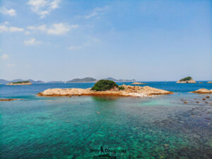
【Finish】 Keep pushing forward until you reach Green Egg Island. The water here is 『crystal clear』 — arguably some of the best in Hong Kong — making it a prime spot to relax and soak up the sun. Whether you’re into snorkeling, swimming, or just having a simple picnic, it’s a fantastic place to enjoy the tranquility of nature. After a well-deserved 『breather』 at Green Egg Island, you can retrace your steps along the same path to return to Tai Au Mun for your trip home.

Here are the reference statistics for this journey:
Related Videos
Transport Guide
START
Tai Au Mun
- From MTR Diamond Hill Station: Take 《Bus 91》 and get off at the Tai Au Mun bus stop.
- From Kwun Tong Ferry Pier: Take 《Minibus 103》 and get off at the Tai Au Mun bus stop.
- From MTR Tseung Kwan O Station: Take 《Minibus 103M》 and get off at the Tai Au Mun bus stop.

END
Tai Wan Tau Road, Bus Stop
- Take 《Bus 91》 back to MTR Diamond Hill Station.
- Take 《Minibus 103》 back to Kwun Tong Ferry Pier.
- Take 《Minibus 103M》 back to MTR Tseung Kwan O Station.

Route Breakdown
🚩
Full Route
《Tai Au Mun → Clear Water Bay Equestrian Centre → Green Egg Island Path → Green Egg Island》
1. 📍 Start: Tai Au Mun, Bus Stop
Tai Au Mun, Bus Stop
2. 📍 Lung Ha Wan Road 《I》

Lung Ha Wan Road 《I》
3. 📍 Cham Shan Monastery

Cham Shan Monastery (湛山寺)
4. 📍 Chi Shing Road

Chi Shing Road
5. 📍 Lung Ha Wan Road 《II》

Lung Ha Wan Road 《II》
6. 📍 Lung Ha Wan, Rock Carving

Lung Ha Wan, Rock Carving
📷 Tips:
- If you’re a history buff, take a quick left turn here to visit the prehistoric Rock Carving by the shore.
7. 📍 Lung Ha Wan Road 《III》

Lung Ha Wan Road 《III》
📷 Tips:
- The View: Right in front is Shelter Island (牛尾洲).
- Distance (Right): You can spot Jin Island (吊鐘洲) and Kau Sai Chau (滘西洲).
- Distance (Left): The sharp, distant peak is Ma On Shan (馬鞍山).
8. 📍 Lung Ha Wan, Shingle Beach


Lung Ha Wan, Shingle Beach
9. 📍 Clear Water Bay Equestrian Centre

Clear Water Bay Equestrian Centre
10. 📍 Lung Ha Wan, Kite Flying Area

Lung Ha Wan, Kite Flying Area
11. 📍 Lung Ha Wan Country Trail

Lung Ha Wan Country Trail
12. 📍 Clear Water Bay Equestrian Centre

Clear Water Bay Equestrian Centre 《I》

Clear Water Bay Equestrian Centre 《II》
13. 📍 Green Egg Island Path, Entrance

Green Egg Island Path, Entrance
14. 📍 Green Egg Island Path 《I》

Green Egg Island Path, Looking back at Lung Ha Wan
15. 📍 Green Egg Island Path 《II》

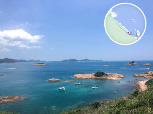
Green Egg Island Path, Distanced View of Green Egg Island

Surrounding Islands of Green Egg Island
16. 📍 Green Egg Island Path 《III》


Green Egg Island Path, Green Egg Island at your feet
17. 📍 Green Egg Island Path, Exit

Green Egg Island Path, Exit
18. 📍 Green Egg Island


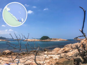
Green Egg Island (綠蛋島)
19. 📍 Finish: Tai Wan Tau Road, Bus Stop
