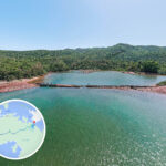
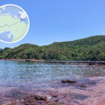
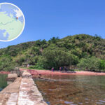
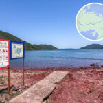
🚶🏻➡️【Hung Shek Mun Path (紅石門徑)】 is a highly challenging and hidden hiking route located northeast of Plover Cove Reservoir in Tai Po District. Situated within the boundaries of the Yan Chau Tong Marine Park, it is famous for its unique crimson rocky shores. Known as the “Fiery Red Coast” due to its flame-like red rocks, this vibrant landscape is caused by the oxidation of rich iron minerals within the rocks, creating a striking contrast with the surrounding green hills and blue waters that looks like a natural piece of art. —
📍 Location and Background
Location: Northeastern New Territories, Tai Po District
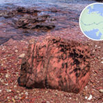
Landscape: Danxia landform, with rocks containing iron oxide that gives them a red hue
Features: Sedimentary rock with clear, distinct stratification and spectacular scenery
—
🌋 Geological Wonder: Danxia Landform
Iron-rich minerals within the rocks have been transformed into red iron oxide through oxidation.
The sedimentary rocks feature clear layers and vivid colors ranging from red and orange to pink, a phenomenon commonly found in arid and hot regions.
Hung Shek Mun is one of the few places in Hong Kong where you can see Danxia landforms, sharing a similar geology with the Danxia Mountain in Mainland China.
—
🌋 Landscape Features
Danxia Landform: Iron-rich sedimentary rocks that have turned crimson through oxidation.
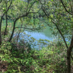
Flaming Red Coast: The rocks form a powerful contrast with the shoreline; visiting during low tide is highly recommended.
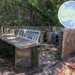
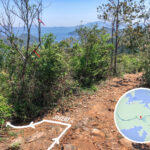
— The Hung Shek Mun Path is around 15.5 to 17 kilometres long and usually takes 7 to 8 hours to complete. Starting from Wu Kau Tang, the trail offers scenic highlights including panoramic sea views of Double Haven (Yan Chau Tong), mountain vistas from Kwun Yam Tung, the small Hung Shek Mun reservoir, and ruins of abandoned village houses. Upon reaching Hung Shek Mun, hikers can stroll along the coastline to admire the iron-rich sedimentary rock layers, surrounding mangroves, and secluded bays. Remnants of old dams once used as fish ponds can still be seen, reflecting the wisdom of early villagers in working with nature. Renowned for its unique red rock formations and Danxia landforms, this path stands as one of the most geologically distinct hiking routes in Hong Kong. —
No replenishment points along the way; must bring your own water
Recommendations
Long trousers, slip-resistant shoes, GPS device, hike with experienced companions
—
🗺️ Detailed Route Sections
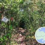
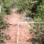
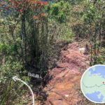
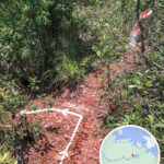
The route sets off from Wu Kau Tang, follows the Miu Sam Ancient Trail past Sam A Tsuen, Kau Tam Tso, Sheung Miu Tin, and Ha Miu Tin, before joining the Plover Cove Country Trail toward Tai Tung and Kwun Yam Tung. Along the way, keep an eye out for ribbon markers on trees to enter the bush paths, head downhill toward the small Kat O Water Supply Reservoir, bypass the abandoned houses of Hung Shek Mun Village, and you will arrive at the Hung Shek Mun coast. For the return journey, simply retrace your steps.
Location
English Name
Features & Description
烏蛟騰
Wu Kau Tang
Starting point, accessible by taking green minibus 20R from Tai Po Market
九擔租
Kau Tam Tso
A Hakka village along a flat path, shaded by Sweet Gum trees
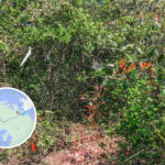
📍 Most of the route consists of unofficial trails with numerous forks, making it easy to get lost; hiking with experienced guides is highly recommended.
🧭 A reliable GPS or offline map app (like Hiking Trail HK) is essential.
🥾 Wear long trousers, slip-resistant hiking shoes, a hat, sunscreen, and bring a headlamp and a first-aid kit.
🧃 Bring plenty of food and water; there are no replenishment points along the entire route.
👥 Hike with experienced companions; beginners should absolutely not go alone.
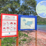
🚫 Hung Shek Mun is a Marine Park; destructive behaviors such as collecting rocks, camping, and fishing are strictly prohibited.
🥪 Prepare at least 3–4 litres of water along with high-energy snacks.
⚠️ Avoid hiking on rainy days as the trail becomes slippery and hazardous.
—
📸 Top Photo Spots
🔥 Hung Shek Mun Coast: The contrast between the crimson rocks and blue sea offers an incredible visual impact.
🌄 Tai Tung Summit: Overlooks the beautiful bays of Double Haven, especially stunning at sunset.
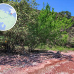
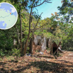
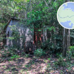
🌿 Abandoned Village: A mysterious vibe where nature completely blends with history.
—
📸 Photography Tips
Best Time to Shoot: Morning to midday, when the sunlight catches the rocks at their most vibrant red.
Recommended Angles: Capturing a bird’s-eye view of Hung Shek Mun Bay from high ground, or getting close to the shore to shoot the rock textures.
Safety First: The rocks by the shore can be wet and slippery; never stand too close to the edge.
—
📚 Trivia: How Hung Shek Mun Got Its Name
“Hung Shek Mun” (literally meaning Red Stone Gate) is named after its flame-red coastal rocks, which align to look like a natural stone gate. It is said that fishermen in the old days used this as a landmark to navigate the shipping channels.