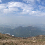
🐉 【Lung Tam Shan (龍潭山)】 is a prominent peak standing at approximately 550 meters above sea level in northwest New Territories. It forms a key part of the dramatic, rolling ridgeline of Kai Kung Leng (Rooster Ridge), standing shoulder-to-shoulder with Lo Tin Ting (585m) and Tai Lo Tin (572m). This expansive mountain range offers completely unobstructed, sweeping vistas over the Yuen Long Plain, the Mai Po Wetlands, and even the distant skyline of downtown Shenzhen, earning its status among local hikers as the ultimate “back garden of the northwest.” The ridgeline stretches from east to west, showcasing a dynamic, ever-changing landscape of wide-open grassy slopes and rugged, rocky trails. On crisp autumn and winter days, the summit provides a perfect vantage point to watch the setting sun paint the Yuen Long Plain in golden hues, while spring and summer bring a vibrant blanket of lush greenery across the hills.
📌 Quick Facts
Category Details 📍 Location Northwest New Territories, nestled between Yuen Long and Sheung Shui. ⛰️ Elevation Approx. 550 meters 🏔️ Mountain System One of the main peaks comprising the Kai Kung Leng massif. ⛰️ Principal Peaks Kai Kung Leng is made up of three distinct summits: Lung Tam Shan (550m), Lo Tin Ting (585m), and Tai Lo Tin (572m). 🧭 Surrounding Topography North: Ngau Tam Shan (337m), Ki Lun Shan (222m)
East: Tai To Yan Ridge
Southwest: Yuen Long Plain
Distant North: Mai Po Wetlands, Shenzhen City skyline🌳 Country Park Lam Tsuen Country Park 🏛️ District Administration The vast majority falls under Yuen Long District, while the northeastern foothills cross into North District. —
—
🌄 Geographical Features
- Ridgeline Orientation: Stretches continuously from east to west, anchored by Tsiu Keng on one end and Fung Kat Heung on the other.
- Neighboring Peaks: Surrounded by Ngau Tam Shan, Ki Lin Shan (Kirin Hill), Tai To Yan, and Pak Tai To Yan.
- Panoramas: Looks out south over the sprawling Yuen Long Plain and the protected Mai Po Wetlands, while offering clear, cross-border views of Shenzhen to the north.
- Natural Environment: The high ridgeline is entirely open and exposed with virtually zero tree cover or shade, making it intensely hot during summer months.
—
遠足 🥾 Hiking Information
Item Details Common Route Fan Kam Road → Lung Tam Shan → Lo Tin Ting → Tai Lo Tin → Fung Kat Heung Total Distance Approx. 6.5 km Time Needed Approx. 5 hours Difficulty ⭐️⭐️⭐️⭐️ (Advanced: Expect steep inclines, heavy elevation changes, and loose, eroded terrain) Transport Start: Take KMB Bus 77K and get off at Fan Kam Road.
End: Catch Green Minibus 603 from Fung Kat Heung to head back to Yuen Long.—
📸 Photography & Scenic Highlights
- Yuen Long Plain: Captures a vast tapestry of traditional farmlands and rustic village settlements below.
- Mai Po Wetlands: A world-renowned haven for migratory birds that offers incredibly dramatic sunset vistas.
- Tai Sang Wai: An excellent location along the way for framing standard shots of fishponds and reflective wetland horizons.
- Shenzhen Skyline: Unlocks a stunning cross-border perspective, with the night views across the river looking particularly mesmerizing.
—
⚠️ Important Safety Tips
- Complete Lack of Facilities: This raw section of the country park has absolutely no public toilets, pavilions, or water refuel points along the trail.
- Loose Footing: Parts of the dirt track are severely eroded and slippery with loose gravel, largely due to illegal off-road motorcycling activity.
- Seasonal Planning: Hardcore summer heat makes this exposed route hazardous; it is best saved for the cooler, clear days of autumn and winter.
- Experience Required: This trail is best suited for fit, experienced hikers who are fully prepared with ample hydration and proper non-slip footwear.