🌸【Mui Fa Ancient Trail (梅花古道)】 is a historic village path nestled in the Sha Tin District of the New Territories, Hong Kong. Connecting Mui Tsz Lam Village with Fa Sam Hang Village, the trail spans approximately 2.5 to 5.3 kilometers. Once a vital transport artery for local villagers, it has transformed into a popular hiking route that beautifully blends lush natural scenery with traditional Hakka culture. —
📌 Key Information
Item Details 🗺️ Route Name Mui Fa Ancient Trail 📍 District Sha Tin District, New Territories, Hong Kong 🚶♂️ Starting Point MTR Tai Shui Hang Station Exit B → Chevalier Garden → Mui Tsz Lam Road 🏁 Finishing Point Fa Sam Hang Village → Wong Nai Tau Bus Terminus 📏 Distance Approx. 2.5 to 5.3 km ⏱️ Duration Approx. 1.5 to 2 hours 🧗♀️ Difficulty Beginner to Intermediate (some sections require light scrambling) ⛰️ Highest Point Nui Po Au (approx. 250 meters above sea level) 🌳 Trail Highlights Densely shaded canopy, cascading mountain streams, and rich biodiversity; offers distant views of Ma On Shan and downtown Sha Tin 🏡 Cultural Sites Mui Tsz Lam Village (Hakka settlement with the Ng Clan Ancestral Hall), Fa Sam Hang Village (well-preserved primitive countryside character) 🚌 Transportation Start: MTR Tai Shui Hang Station; End: Wong Nai Tau Bus Terminus or Kwong Yuen Estate 🧃 Provisions A local honey farm and small refreshment stops are located near Mui Tsz Lam Village ⚠️ Precautions Paths become slippery after rain; respect local villagers and privacy; non-slip hiking footwear and trekking poles are highly recommended 🧭 Extensions Connects to Nui Po Shan, Sha Tin Country Trail, and Ma On Shan Country Park — The Mui Fa Ancient Trail is rated beginner-to-intermediate in difficulty. Certain stretches feature steeper gradients and rocks that gather moss, meaning extra caution is required on wet days. The trail is well-equipped with clear directional signage and pavilions. With its convenient pit stops like the local honey farm near Mui Tsz Lam, the route is ideal for families looking for a leisurely stroll, heritage buffs keen on exploring traditional Hakka architecture, and hikers looking for a gateway to Nui Po Shan or the broader Sha Tin Country Trail network. —
🧭 Recommended Route Breakdown
🔹 Inbound Section (Tai Shui Hang Station → Mui Tsz Lam Village)
- A brisk 10-minute walk from the MTR station leads straight into Mui Tsz Lam Road.
- Begins as a paved concrete road before gradually transitioning into a natural dirt mountain trail.
🔹 Mid-Trail Section (Mui Tsz Lam Village → Nui Po Au)
- Crosses into the boundary of the Ma On Shan Country Park.
- The path turns noticeably steeper, requiring light climbing. The thick overhead canopy keeps the area wonderfully cool and shaded, making it a great summer escape.
🔹 Descent Section (Nui Po Au → Fa Sam Hang Village → Wong Nai Tau)
- An easy descent down a paved pathway, passing the iconic heart-shaped rock before entering Fa Sam Hang Village.
- Concludes with a short walk to the Wong Nai Tau Bus Terminus for urban transit connections.
— The Mui Fa Ancient Trail boasts diverse terrain and scenery, ranging from rushing hillside brooks and cool shaded forests to the massive heart-shaped boulder. Along the way, hikers can enjoy open views stretching toward Ma On Shan and downtown Sha Tin. The trek kicks off from Tai Shui Hang Station Exit B, cuts past Chevalier Garden, and enters Mui Tsz Lam Road, eventually winding down into Fa Sam Hang Village. Named after its deep mountain ravines and dense surrounding forests, Fa Sam Hang Village is home to just a single remaining household from the Yip clan, beautifully preserving a quiet, old-world rural lifestyle. —
🏞️ Major Scenic Highlights & Cultural Sites
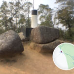
🏡 Mui Tsz Lam Village
- A historic Hakka village featuring a century-old Ng Clan Ancestral Hall and traditional agricultural plots.
- The active farmland and honey farm at the village perimeter double as great rest areas and photography spots.
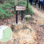
- The main trail starts directly on the right side of the clearly marked village entrance signpost.
⛰️ Nui Po Au
- The highest pass along the ancient path, standing at roughly 250 meters.
- Offers sweeping, panoramic vistas over Ma On Shan and the Sha Tin urban skyline.
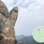
- Serves as a junction to scale Nui Po Shan, where hikers can check out famous rock formations like Penis Rock (Yang Yuan Rock) and Tofu Rock.
- Historically nicknamed “Lui Po Shan” (Thunder Goddess Mountain) due to local folklore branding it a hotspot for lightning strikes in Sha Tin.
🪨 Penis Rock & Tofu Rock
- Unique rock formations scattered across the ridges of Nui Po Shan.
- The distinct shape of Penis Rock has made it an immensely popular photo checkpoint for passing hikers.
💖 Fa Sam Hang Village & Fa Sam Rock
- A serene, elegant hamlet hidden away amid deep ravines and thick woods.
- The exceptionally quiet village grounds are home to a single resident family.
- The village’s signature landmark is the “Fa Sam Rock”—a massive, natural heart-shaped boulder that draws many visitors.
- The final descent from here is flat and relaxed, making for a perfect warm-down walk.
—
🚶♀️ Hiking Itinerary Suggestions
⏰ Timeline Planning
- We recommend gathering at Tai Shui Hang Station at 10:00 AM.
- The complete route takes roughly 2 hours, making it an excellent half-day excursion.
🍽️ Dining & Food Provisions
- Pick up fresh honey products and basic refreshments near Mui Tsz Lam Village.
- Upon reaching the end of the trail, you can head over to Kwong Yuen Shopping Centre for a variety of local dining options.
—
🧭 Recommended Trail Extensions
Route Distinctive Features Nui Po Shan Standing at 399 meters, the peak is packed with unusual crags, including the Thunder Rock and Fish Basket Rock. Sha Tin Country Trail The Mui Fa Ancient Trail makes up a core section of this network; ideal for long-distance hikers looking to extend their trek. Ma On Shan Country Park Rich natural biodiversity with a massive network of connecting mountain trails to explore. —
⚠️ Essential Safety Reminders
- 🧤 Recommended Gear: Pack trekking poles, sturdy non-slip footwear, hiking gloves, and plenty of drinking water.
- 🌧️ Weather Awareness: Rock surfaces become incredibly slick during wet weather; always opt for a clear, sunny day for this hike.
- 🙏 Cultural Respect: Keep noise levels down when passing through local villages to respect the privacy and peace of local residents.
- 📱 Keep a reliable GPS-enabled map app open on your phone to assist with navigation.
—
📌 Insider Tips
- Spotting Freshwater Crabs: Keep an eye on the mountain streams—you’ll often spot tiny freshwater crabs scuttling along the rocks.
- Sun Exposure: Around 20%. The trail runs mostly under deep forest canopy, making it highly suitable even on hot summer days.
- Best Suited For: Family outings, landscape photographers, and cultural heritage explorers.
—