🏔️【Robin’s Nest (紅花嶺 / 麻雀嶺 — also known as “Ma Tseuk Leng”)】 is the highest peak in the northern part of Hong Kong’s New Territories, standing at 492 metres above sea level. Located west of Sha Tau Kok and east of Ta Kwu Ling, it sits within the boundaries of Robin’s Nest Country Park, which was officially established on 1 March 2024. This mountain forms the core of Hong Kong’s 25th country park. It draws its Chinese name from the wild Red Azaleas (Rhododendron simsii) that blanket the hillsides in spring, while its alternative Chinese name, “Ma Tseuk Leng” (Sparrow Ridge), stems either from the local Hakka pronunciation for “Ma Chuk” (bitter bamboo) or from the abundance of wild birds nesting across the area. Due to its close proximity to the border, Robin’s Nest was sealed off as a Frontier Closed Area for decades. Its recent gradual reopening has transformed it into a natural sanctuary that blends rich ecological conservation with profound cultural history. —
📍 Origin of Names
- Robin’s Nest (紅花嶺) : Perched in the northern New Territories between Ta Kwu Ling and Sha Tau Kok, this 492-metre peak is the highest summit in the North District and directly overlooks the Hong Kong-Mainland border.
- Alternative Chinese Name : Ma Tseuk Leng (麻雀嶺), often used interchangeably with Robin’s Nest. Local lore attributes the name to two possible sources:
- The flocking of passerine birds (sparrows and finches) across the ridges.
- The local Hakka village “Ma Tseuk Leng Village,” which was famous for cultivating Ma Chuk (bamboo)—a term whose Hakka pronunciation sounds very similar to “Ma Tseuk” (sparrow).
- English Name “Robin’s Nest” : Refers literally to the nesting place of robins. It traces back to historical sightings of the Eurasian Robin, which, despite not being a native breeding species in Hong Kong, came to symbolize the mountain’s role as a vital avian haven.
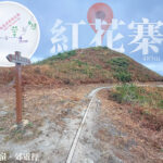
English Name Chinese Name Description Robin’s Nest 紅花嶺 Named after the vibrant wild Red Azaleas that carpet the peaks in spring Red Flower Fort / Ben Nevis 紅花寨 Legend has it that anti-Qing soldiers once built a fortress here Ma Tseuk Leng Village 麻雀嶺村 An old Hakka settlement historically renowned for its sprawling bamboo groves Lin Ma Hang 蓮麻坑 A village named after a native wild plant found abundantly along the valley —
🚍 Transport & Closed Area Information
- Recommended Trailhead Access : From Fanling or Sheung Shui MTR Station, take KMB Bus 78K or green minibus 55K to the Tan Shui Hang stop.
- Border Permit Exemption : Since 2025, the closed area road leading to Lin Ma Hang Village has been opened to the public. Hikers riding the designated green minibus can now enter Lin Ma Hang Village directly without applying for a Frontier Closed Area Permit.
- Essential Tips :
- There are no replenishment points or kiosks along the trails; hikers must bring all their own food and water.
- It is highly recommended to pack trail maps, headlamps, sun protection, and proper hiking gear.
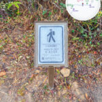
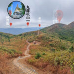
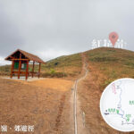
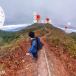
— The hiking routes up Robin’s Nest are widely known for their challenging nature. The primary paths comprise the Robin’s Nest Country Trail and the Lin Ma Hang Trail, covering a total distance of roughly 10 kilometres. The hike takes about 5 hours and is rated 4 out of 5 stars in difficulty by the AFCD. Along the ridges, hikers can discover World War II Japanese machine gun pillboxes, British military observation posts, and the historical MacIntosh Forts (constructed between 1949 and 1953 to curb illegal immigration). For transport, you can kick off from Fanling or Sheung Shui Station by catching Bus 78K or minibus 55K to Tan Shui Hang. After finishing at Lin Ma Hang Village, you can hop on minibus 59K to return (permit-exempt since January 2025). Given the lack of supply points and several steep, rugged sections, carrying ample water, sun protection, and a torch is vital. —
🥾 Hiking Route Breakdown
🔸 Robin’s Nest Country Trail 🔸 Lin Ma Hang Trail
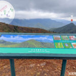
Item Details Total Distance Approx. 10.6 km Duration Approx. 5–7 hours Elevation Gain Approx. 703 metres Difficulty Intermediate to Advanced (4 Stars) 📸 Scenic Highlights & Check-in Spots
- Ah Kung Top (亞公頂) : Standing 394 metres high, its sharply ascending trail is locally dubbed the “Sky Ladder.” It offers a demanding climb and houses an old military lookout point.
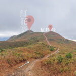
- Yi Tung and Sam Tung (二峒、三峒) : The scenic ridgelines connecting Hung Fa Chai and Ma Tseuk Leng, offering completely unobstructed, expansive vistas.
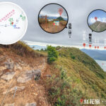
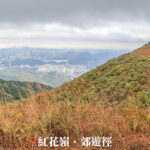
- Hung Fa Chai (Robin’s Nest Ridge) : At 489 metres high, this spot delivers magnificent panoramic views of the mountains meeting the sea.
- Lin Ma Hang Village (蓮麻坑村) : A charming Hakka village steeped in over 300 years of agricultural and cultural heritage.
- Robin’s Nest Viewing Point (紅花寨觀景台) : A dedicated vantage point looking out far over Starling Inlet, Luk Keng, and Nam Chung.
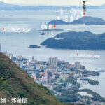
— The natural landscape of Robin’s Nest is remarkably diverse. Tracking the ridgeline from Ah Kung Top to Hung Fa Chai unfolds views of Starling Inlet and the Luk Keng wetlands, contrasted against the soaring urban skyline of Shenzhen and Wutong Mountain across the border. Over 650 species of plants and animals have been logged in the area. This includes the vulnerable Chinese Grassbird (with Hong Kong supporting around 90% of its global population), colonies of bats roosting inside the Lin Ma Hang caves, and birds of prey like the Crested Serpent Eagle. The changing seasons bring distinct colors: wild azaleas color the hillsides pink and red in spring, while silvergrass sways elegantly in the winter breeze. Additionally, the historic Lin Ma Hang Lead Mine has been revitalized into an open-air exhibition area showcasing local mining history and unique geological features. —
🌳 Robin’s Nest Country Park
Item Information Date Established 1 March 2024, becoming Hong Kong’s 25th country park Total Area Approximately 530 hectares, completely composed of government land Managing Authority Agriculture, Fisheries and Conservation Department (AFCD) Key Features Nestled along the border area, its long-term closed status kept human disturbance low, yielding exceptional conservation value Geographical Traits North Slope: Dominated by lush secondary forests and shrubland; South Slope: Blanketed by upland grasslands with immense ecological value Ecological Corridor Directly adjoins Shenzhen’s Wutong Mountain to form a vital cross-boundary ecological pathway —
🐾 Ecological Value & Biodiversity
🌳 Vegetation Patterns
- North Slope : Secondary Forest 🌲 and Shrubland 🌿
- South Slope : Upland Grassland 🌾
🌺 Native Flora
- Hong Kong Pavetta (Pavetta hongkongensis): A beautiful native shrub
- Chinese New Year Flower / Bellflower (Enkianthus quinqueflorus)
- Common Melastoma (Melastoma candidum): A resilient native wild plant
- Chinese Gordonia (Gordonia axillaris)
- Red Azalea (Rhododendron simsii): Bursts into bright red blooms across spring, inspiring the mountain’s Chinese name
🐾 Wildlife (Over 650 Species recorded)
- Japanese House Bat (Pipistrellus abramus)
- Himalayan Whiskered Bat (Myotis altarium)
- Yellow-bellied Weasel (Mustela kathiah)
- Crested Serpent Eagle (Spilornis cheela)
- Crested Goshawk (Accipiter trivirgatus)
- Chinese Grassbird (Graminicola striatus): A rare species whose global population is highly concentrated here, with Hong Kong hosting about 90% of them
- Greater Bent-winged Bat (Miniopterus schreibersii): Forms massive colonies inside the hollows of the Lin Ma Hang Lead Mine
—
🏛️ Historical Sites & Cultural Resources
🛡️ MacIntosh Forts
- Built between 1949 and 1953 as strategic border observation posts to safeguard the frontier and deter illegal immigration.
- Two of these iconic forts stand within the park’s boundaries and are protected as Grade II Historic Buildings.
🔹 Japanese Pillboxes
- Military defensive structures erected by Japanese forces during WWII to counter Allied advances and local guerrilla resistance.
- Though accessible to visitors, their interior chambers are tight and narrow, so caution is advised when exploring.
🔹 Ma Tseuk Leng Beacon Tower (麻雀嶺條台)
- Originally set up during the Qing Dynasty as part of a coastal defense system, later serving as a military outpost station.
- Perched atop Wo King Shan (禾徑山) to the southwest of Robin’s Nest.
🦇 Lin Ma Hang Lead Mine
- Mining operations date back to the 1860s, expanding by the 1930s to employ over 500 workers.
- Once operated as one of Hong Kong’s premier mining networks, extracting rich deposits of lead, zinc, and iron pyrites.
- Seized and controlled by Japanese forces during the World War II occupation.
- Abandoned in the 1960s, the empty tunnels naturally transformed into a sanctuary for diverse bat species.
- Designated as a Site of Special Scientific Interest (SSSI) in 1994, it serves today as an educational display area and vital bat conservation site.
- The famous “Mine Pit No. 6″—popularly known as “The Hall”—has been revitalized with safe walkways and informative displays for visitors.
—